UPDATE THURSDAY AM: Seattle in a little over five days has exceeded its normal MONTHLY total (3.72 inches). Yesterday (Wednesday), Sea-Tac received 1.84 inches. Through midnight, Seattle precipitation totaled 3.66. But since midnight it has enjoyed another .13 inches (as of 9 AM), giving a monthly total of 3.79 inches.
We seem to be experiencing a reversal in seasons. November is normally wet and blustery, with a good chance of flooding and strong winds. March is generally a month in which the risk of flooding and high wind recedes.
November 2013 was dry over most of the Northwest, with 3.79 inches at Seattle Tacoma Airport, 2.78 inches below normal. February 2014 had 6.11 inches at Sea Tac, 2.61 inches above normal. March so far (5 PM Wednesday) has brought over 2.35 inches and much more is on the way.
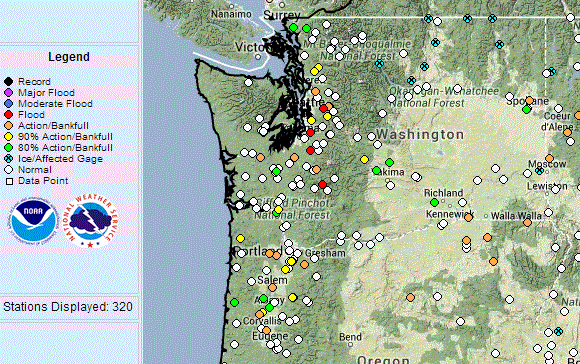
Flood levels are predicted by the Northwest River Forecast Center for a number of western Washington rivers (see graphic)
and the latest satellite image shows a line up of storms heading for the West Coast that really looks like mid to late fall (see image).
Precipitation amounts over the region during the past 24h (ending 6 PM Wed) have been downright impressive (see graphic) with some mountain areas getting 4 inches and more and even many lowland
gauges soaked by 1.5-2 inches. And this is warm rain with a very high freezing level, leading to all kinds of avalanche problems in terrain.
And it is not over yet. To start with, it is pouring outside right now, with local urban flooding. But take a look at the precipitation forecasts for the next two 72 hr periods. In both time slices, the Washington Cascades get 2-5 inches, and even more in the mountains of BC. Washington snowpack numbers are starting to surge above 100% of normal. Oregon gets plenty as well, particularly during the second 72 hr. Oregon still has below normal snowpack, but there are moving up to normality fast. Most exciting of all this is that northern California gets substantial precipitation, further aid towards refilling the big reservoirs in that part of the State.
Take a look at Lake Shasta, the biggest reservoir in CA. The dark blue line is this year's storage, which is now heading upwards fast (the light blue represents normal conditions). Reservoir levels are now pulling away from the terrible 1976-1977 situation (red line).
And small reservoirs in S. California near LA are above normal after the huge rains last week, Here is Pyramid Lake:
With the Colorado River Basin enjoying above normal snowpack, it is increasingly looking like CA will sneak by this year, with some impacts to agriculture being inevitable at this point.
The reason for all this early winds warmth and precipitation: a shift to persistent southwesterly flow aloft:
Want to experience spring time warmth on Friday and Saturday? Head to the Tri-cities where the low to mid 60s will be waiting for you.
The European social model is a common vision many European states have for a society that combines economic growth with high living standards and good ...


No comments:
Post a Comment