After an extraordinarily wet period, the big question is whether April will be more typical. Average April rainfall at Seattle-Tacoma Airport is 2.59 inches, a far cry from the 9.44 inches we endured in March.
So let's take a look at some of our most powerful prediction tools, whose skill degrade rapidly past a week or so into the future. First, there is the output of the North American Ensemble Forecasting System (NAEFS) shown below. By looking at many numerical simulations encompassing NAEFS we can get an idea of uncertainties. The second panel is precipitation and the median values (half the ensembles are more, half less) are shown by the horizontal line. 75% of the ensembles are within the yellow boxes. Fairly dry the next few days and then wetter Friday to Sunday. But next week looks fairly dry with a warm spell on the 9th and 10th. Not too bad really.
The UW WRF model is consistent with this. Here is the 72 h precipitation forecasts precipitation totals ending 4 AM on Friday. Not too bad...less than a third of an inch over the lowlands.
The next 72 hr is much wetter (ending 4 AM on Monday) , particularly over the mountains.
But early next week it all changes, with a large ridge developing over the eastern Pacific (see upper level map for Monday at 10 AM). Dry and warm.
The European Center emsemble (yes, the best in the world) are consistent with this solution (left panel below). Here are the forecasts for Tuesday:
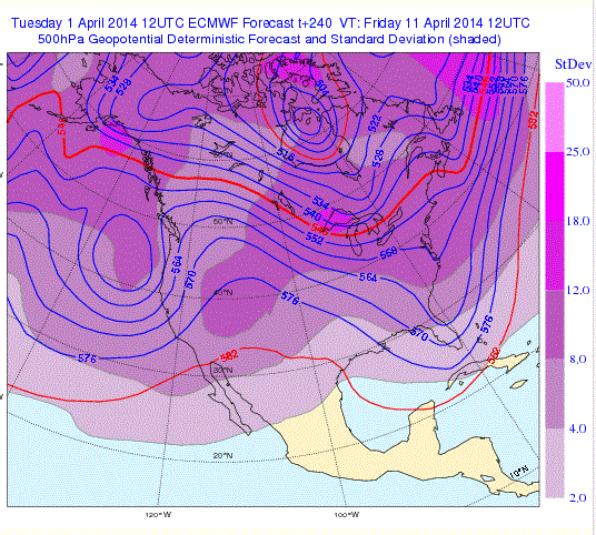
The ridge should move eastward on Wednesday and a low pressure system will develop offshore, pushing most of the action into California (see European Center forecast for Friday morning).
For us, this implies that we might get some weak systems, but no downpours, later next week.
Forecast skill drops rapidly after that, but we do have one tool to use: the NWS Climate Forecast System (CFS) that goes out 9 months! Her is the anomaly (difference) from climatology (average April precipitation) for April. Modestly above-normal precipitation over the western side of Washington (green color). Normal east of the Cascades.
But can we believe this? The CFS is based on an ensemble of extended forecasts and by looking at their agreement, a measure of confidence can be calculated. Here is the confidence map...where it is grey there is low confidence. Does not look particularly reliable over our region, so the bets are off!
So enjoy the next few days and be ready for real fun in the sun Monday and Tuesday of next week.
Announcements
Professor John Delaney will be giving several talks on the topic: 20,000 Gigabytes under the Sea.
More information here.
KPLU Pledge Drive is going on now. They are a great public radio station and deserve your support. And they even have me on each week! To help support KPLU go here.
The European social model is a common vision many European states have for a society that combines economic growth with high living standards and good ...
Subscribe to:
Post Comments (Atom)
.png)
.gif)
.gif)


No comments:
Post a Comment