Is it REALLY July 7th?
Let me "warm up" by showing you the infrared satellite image this morning. Clouds extend from the Northwest to far out over the Pacific.
The precipitation maps for the next 6 days would discourage anyone thinking about outdoor fun. The next three days precipitation total has rain over the entire region. with North Cascades getting particular attention.
The subsequent three days has light rain west of the Cascades crest, but very large amounts over western Montana and eastern Idaho.
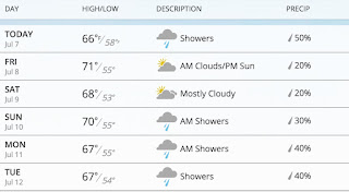
The latest weather.com forecast for Seattle has clouds, showers, and temperatures in the upper 60s
The forecasts for the mountains? You don't want to know about that.
This cool/wet/cloudy weather is associated with persistent low pressure (troughing) over the region.
Now you really want to see something amazing? Here is the upper level (500 hPa) map (showing heights and temperature) for 5 PM Saturday. Stunning. Deep low off the WA/OR border with the jet stream (where the lines are close together) pushing southward into northern CA.
The temperatures at this level will approach daily low records at local radiosonde stations (Quillayute, WA and Salem, OR).
Any snow with this pattern? Of course! Here is the snowfall for the 24h ending 5 PM Monday. Parts of Idaho, Grand Tetons, and Yellowstone will get snow. That will surprise some visitors!
These is a good chance this will end up one of the coolest Julys in years for the Northwest. And remember: climatologicaly the driest/warmest period of the entire year is only three weeks away!


No comments:
Post a Comment