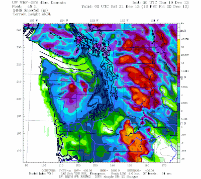
The chances of snow on Friday morning are now very high and in this blog I will explain why. I will also paint out some of the uncertainties, including the snow depths and when snow will give way to rain.
But the bottom line is clear: the commute time on Friday morning will be a white one, so be prepared.
Friday morning in Seattle?
Several years ago, I did a paper called "Snowstorms over the Puget Sound Lowlands" with Garth Ferber and Mike Patnoe, where we described the origins of western Washington snow events. Most occurred in one of two situations:
- as cold air moved into the region
- as resident cold air was displaced by approaching warm air.
First, you need cold. Done. Today the passage of an upper trough pulled cold air into Washington State. Here is what is called a time-height cross section of conditions over Seattle-Tacoma Airport. Time increases to the left, the red lines are temperature (C), wind barbs are shown, and height is in pressure (850 indicates about 5000 ft). Temperatures have cooled substantially during the day (the red lines are heading down!). The freezing line (0C) is now at about 950 hPa pressure, which corresponds to roughly 1700 ft. The snow level is about 1000 ft below that (700 ft). And the air will continue to cool down overnight.
The air is also much drier. A good measure of moisture content of the air is dew point. The higher dew point the more moisture in the air. Here is the plot of dew point at the UW Atmospheric Sciences building today. The dew point dropped from around 40F to roughly 30F. Much drier.
Why do we care about the air being dry? As precipitation falls into such dry air there is a lot of evaporation (or sublimation if ice crystals). These processes cause a LOT of cooling. Good for snow.
Early Friday morning, a potent warm front will be approaching our Pacific Coast (see the surface weather map at 1 AM Friday morning). There is GREAT confidence in this forecast. There is consistency between subsequent runs of the NWS models, the UW WRF model, and international models. Timing might shift a few hours either way, but folks, this front is coming. You will notice the blue colors over land (cold air) and the yellow colors offshore (warm air), with a large change of temperature with the front (which also is associated with a trough of low pressure...solid lines are pressure). Changes of temperature with fronts force upward motion, clouds and precipitation. The battle will be between the warm air and the cold air....and the warm air will win. But not before the western interior is painted white.
So we definitely have cold air in place. Definitely have a front with precipitation approaching. The system is hitting during the night without any solar heating.
It is going to start as snow. Very high confidence in that.
So let's watch this unfold...and the latest runs are earlier and heavier on the snow than previous solutions. And let me warn you...this is scary stuff. These figures will show you 3-h snowfall ending at various times.
By 1 AM Friday light snow has begun over western Washington. Less than 1.5 inches in most places.
Three hours ending 4 AM. More snow, but relatively light in the lowlands.
Three hours ending 8 AM. Much heavier, particularly east of the Sound. Notice snow is ending on the coast as temperatures warm.
3-h ending at 10 AM. Snow ending south of Seattle and along the coast, still some over the western slopes and NW Washington.
Three hours ending at 1 PM. Rain is now dominating over the lowlands.
You want to see the totals of all this? Prepare yourselves. Mountains are hammered with over a foot. Seattle ends up with 2-4 inches, with even more in north King County and Snohomish County. Less snow south of Tacoma and over Port Angeles.
There are considerable uncertainties in the amounts, which could easily be different by 50% over the lowlands than shown above. But the probability of snow during Friday AM is very high, so be prepared, such as working from home or staging your car at the bottom of a hill.
We are fortunate to have very competent and prepared highway folks (WSDOT and SDOT) and the technology of dealing with roadway snow and ice are far more advanced than a few decades ago. I suspect SDOT and WSDOT will pretreat the roadways late Thursday and will be ready with a lot of equipment before rush hour. The main roads will probably be fine, but the side streets may be treacherous.
And don't forget our website designed for just these situations (sponsored by the City of Seattle): SNOWWATCH, found here.
Finally, this is as close as we will come to having a white Christmas this year.
Thank You.
I wanted to express my appreciation to all of you that contributed to my weather research fund at the University of Washington this year. During the next year I will use the support to hire some undergraduates to work on local weather research projects and to help maintain the numerical weather prediction system I show in this blog and use as a major tool for local weather research.


No comments:
Post a Comment