6:30 AM Update
The coastal radar shows a weak area of snow showers moving over Hoquiam and the SW WA coast and moving inland over SW WA (see echo). Very light stuff. NOTHING ELSE OUT THERE. So some light snow showers over SW WA is all that we will see this morning. Update for the evening commute and overnight at noon. Could be snow showers this evening.
The forecast for Monday is a very difficult one.
We will have air that is quite cold enough to support snow tomorrow morning. A very weak weather disturbance will approach during the mid afternoon and will bring some light precipitation to the area. As the disturbance moves through temperatures will begin to warm as increased onshore flow occurs. By Tuesday morning commute time it will probably be warm enough for rain over Seattle, with snow holding a bit longer over NW WA.
So for those of your worried about driving to work tomorrow, the morning commute will be fine. No problems at all. Enjoy.
South Seattle should be substantially rain shadowed (or snow shadowed in this case). So if snow falls, it probably will be heavier in the north part of the city--but still not more than an inch. Could easily be much less. As the temperatures warm up aloft, we might see a few hours of freezing rain.
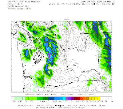
To illustrate, here is the 24 hr precipitation and snowfall ending 4 AM on Tuesday AM. The mountains will get snow ...guaranteed and NEEDED. NW Washington including Everett to Bellingham to the San Juans will get perhaps an inch. Between the rain shadowing in NW flow and warming, Seattle to the Kitsap will not get much...perhaps 1/4-1/2 inch at most. Or virtually nothing.
Not a big event...but any snow in our area can cause problems. And we could get a few hours of freezing rain. God knows what the TV stations will make of it! We will have a much better handle on this tomorrow..I will do a NOWCAST around noon.
Temperatures are already warming quickly aloft. Take a look at the wind and temperature above Seattle Tacoma Airport. At around 5000 ft (850 hPa on chart) the temperatures have warmed from -12 to -6C (that is a warming of around 11F).
Watch the radar tomorrow...you will see in real time what is happening. Precipitation amounts will be everything. No precipitation...no worries. If you see it coming in when you need to be driving or biking...you might get an early start. No big blizzard, but roads can get slick with a little snow. Sea-Tac Airport is 4 F warmer than the same time yesterday--that is true for many local stations. Changes are beginning....
Finally, for those in my ATMS 101 class taking their final exam tomorrow at 8:30 AM....there are no snow excuses. Be there!
The European social model is a common vision many European states have for a society that combines economic growth with high living standards and good ...
Subscribe to:
Post Comments (Atom)


No comments:
Post a Comment