On Thursday afternoon, a Pacific front approached the Northwest coast. The image below, for 2 PM, indicates the front was still well out into the Pacific (the front indicated by the red line I have drawn in). Behind the front there was colder air, as indicated by the speckled instability clouds behind.
There was precipitation with the front, viewable from our wonderful coastal radar later . Take a look at the radar image at 7PM; at that time the front precipitation was just reaching the coast.
But major cooling and a big increase in the winds did not wait for the front to reach us!
To show that, here are the observations in Seattle (University of Washington) from 11 AM on Wednesday (18Z 19 June) to 5 PM on Friday (00Z, 21 June). Times in meteorology is in Greenwich Mean Time (GMT or Z or UTC, 7 hours later than PDT). On Wednesday, temps hit about 65F between 5 and 7 PM and slowly dropped. Winds were modest (5-10 kt).
But Thursday was different. Temps were much higher (around 74), peaked earlier, and then rapidly dropped between 5 and 7 PM. The winds became quite strong, gusting to 21 knots.. The rain (blue line) and the frontal directional change did not occur until around 07 Z (midnight)
This is a good example of a summer frontal passage here in the Northwest. Big changes in weather, including major cooling, occur before the front arrives, often by several hours.
And want to know something else amazing? What time of the year do we get the biggest surface temperature drops with fronts? Summer or winter?
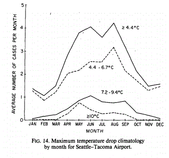
The answer is summer, when the inherent fronts are weaker! Here is the proof, from a paper I did with Dan Brees and Mark Albright. This shows the frequency of one-day surface temperature drops by month for various drop magnitudes. Summer rules!
So why do we get big frontal temperature changes in summer and why do they proceed the front? Why are temperature changes weaker in winter?
It all has to do with the temperatures of land versus water.
The ocean temperatures are nearly always the same off the Northwest coast: about 50F, give or take a few degrees. During the winter, our high temperatures drop into the 40s or low 50s and the near-surface air behind the fronts has been over the mild Pacific for thousands of miles and is highly moderated near the surface. So when the front goes by, the surface air doesn't cool by much. Interestingly, the cooling is far more profound aloft, where the air is not warmed by the ocean's surface.
But during the summer things are very different.
With strong sun, the land can warm up to a far higher temperature than the cool Pacific. As it did on Thursday. The warming is most profound east of the Cascades, where the ocean influence is far less. As the front approaches and before the frontal cooler air can reach us, the onshore winds pick up, flooding the Northwest with cooler air from off the Pacific. Temperatures plummet, even before the front gets here.
But like those famous infomercials: wait, there's more! The warm interior causes the pressure to fall (warm air is less dense than cooler air) and that helps pull in the cool ocean air, as that same time the cool ocean air piles up on the coastal mountains, increasing the pressure. These local pressure differences greatly enhances the landward movement of cool air, producing what we call the onshore or marine push.
I love the marine push. The winds get my wind chimes sounding in the most wonderful way.
Happy Summer Solstice!
The European social model is a common vision many European states have for a society that combines economic growth with high living standards and good ...
Subscribe to:
Post Comments (Atom)

.gif)


No comments:
Post a Comment