Instead of our normal, mild, moist onshore (westerly or southwesterly) flow, the wind turned easterly and strong...a relatively unusual occurrence around here. Cold, dry air from the interior of the continent has swept over the region and much of western Washington is now in the 30s. For the last few months, we almost never got below 50, so this is quite a shock.
The clouds also reversed. Normally, with westerly flow our clouds are banked up on the western slopes of the Cascades. Today, with easterly flow the eastern slopes were shrouded (see pic).
Here are the low temperatures for the 24 hr ending 7 PM. Lows in the 40s over the water. Thirties in western Washington. 20s and teens in eastern Washington--particularly over the higher elevations there. You don't want to know about Montana (0 to 20 degrees below zero). Big sky country is frozen sky country.
As promised, there have been some real winds. A large pressure gradient built over the Cascades as cold air (and associated high pressure flooded into eastern WA), with the pressure difference across the mountains reaching about 8 hPa. That is fairly large.
Air rushed through the Gorge from high to low pressure, producing winds of 60-70 mph east of Portland (see map)
Planes landing at Portland and The Dales experienced moderate to severe turbulence as they entered the strong, accelerating easterly flow near the surface. And several planes reported Low Level Windshear under final approach.
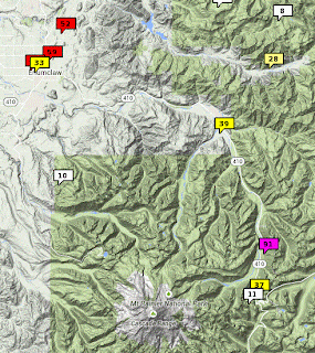
At Crystal Mountain, near Mt. Rainier, winds gusted to 91 mph, while maximum gusts reached 50-70 mph near Enumclaw, whose names means "place of evil spirits." (and we don't mean something that comes out of distillery) Enumclaw and environs is downstream of a low area of the Cascades that allows the air to accelerate westward.
Not only did the air cool down, but it became amazingly dry. Skin-cracking dry.
Take a look at what happened at the University of Washington. As the winds switched from northerly to easterly (around 15 Z 7 AM), the dew point began a nosedive from around 40F to roughly 10F. Relative humidity dropped from 80% to 30%. Winds gusted to 30 knots and we had total sunshine. You might get some skin lotion or moisterizing creme.
And there were strong winds north of Bellingham that accelerated over the water to 40-60 mph. You can imagine what such winds would do to the piles of coal that would exist if a major coal terminal was built at Cherry Point, between Bellingham and Blaine.
Enough excitement for you? We haven't even warmed up (bad word, I know)
Lowland snow is a real possibility near Portland, the Columbia Gorge, and eastern slopes of the Cascades on Thursday as a frontal zone approaches. I mean major snow over the eastern portion of the Gorge.
Here is the 24 h snowfall ending 4 PM on Thursday. A few flurries near Portland (temps are pretty marginal), but the eastern Gorge and eastern Oregon get hammered. We are talking feet of snow from the The Dalles to north of Bend. This forecast could change and max snow area could well shift north or south. But if you are living in that area, I would stock up on food, get some chains, and rent/download a few good movies.
Announcement
Want to sign an online petition supporting improved computers for the National Weather Service? Go to this link!


.png)


No comments:
Post a Comment