Is winter over?
In one sense, the answer is yes. Meteorological winter ends roughly the third week of February in western Washington. After that it is difficult to get the really big winter weather events: record floods, historic windstorm, big lowland snow storms.
We are now close enough to that period to know that it is unlikely that we will get a major event before the typical transition to spring. The persistent ridging that has been the hallmark of this winter is not going anywhere. To illustrate, here is the forecast upper level (500 hPa) weather chart for next Tuesday at 4 PM. Big ridge. Again.
But anyone who has forecast around here for a while, knows that there have been many warm/dry early winters that have been followed by wet/cool late winters/early springs.
Last year was a good example, with the atmospheric tap turning on the second week of February, resulting in a huge increase in snowpack and a near-record wet period---which may have contributed to the Oso landslide.
And never forget that the Cascade snowpack typically increases until roughly April 1st, as illustrated by the following example at Stevens Pass. The green line is the average snowpack there and the black line is this year. As shown by the red line, it has been worse.
But let me be clear, I am not optimistic for the remainder of this year and virtually every tool at my disposal suggests that the preternatural warmth will continue.
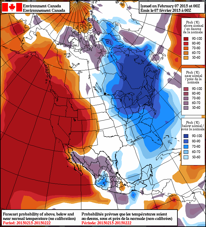
Every long-range forecasting model suggests warmth will continue, as will the associated ridging. To illustrate, here is the forecast temperatures from the North American Ensemble Forecasting System (NAEFS), that combines the long-range model output from the U.S. and Canadian Centers for Feb 15-22nd showing the percentage chance of being above or below normal for that period. They are 90-100% sure it will be warmer than normal. They don't get any more certain than that.
And lets take a look at the National Weather Service's Climate Forecast System predictions for the next three months for surface air temperature (actually the difference from normal--the anomalies). Amazing. A HUGE WARM ANOMALY over our region. And these anomalies are very statistically significant. My confidence in this forecast is strengthened by the fact that is probably the result of a relatively slowly changing atmospheric circulation variation that is connected with slowly varying sea surface temperatures in the Pacific (more on that in a future blog). Note that eastern U.S. is colder than normal. This is not some kind of global warming where everyone experiences higher temperatures.
Finally, let me note that there is an intimate connection between persistent West Coast ridging (high pressure) and the heavy rains (associated with atmospheric rivers). There is a reason we have gone between extended dry periods interrupted by heavy rain.
When the ridge is over us, we are dry. But if it slips to our east a bit, we move into warm, wet southwesterly flow. The example below for Friday night at 7 PM (weather map at 300 hPa) illustrates this situation. The colors are wind speed and the winds are parallel to the height lines.
The Pacific Northwest Weather Workshop
Interested in attending the big local weather workshop of the region? The Pacific Northwest Weather Workshop will be held in Seattle at the NOAA facility on February 27-28th. Everyone is invited and the majority of talks are accessible to laypeople. To attend you have to register or they won't let you in the gate. There will be a major session on the Oso landslide. There is a registration fee that covers refreshments and food, and special student pricing. If interested, check out this website.
Climate Change and the Pacific Northwest
I will be giving a provocative talk on this subject on March 11th at 7:30 PM Kane Hall on the UW campus in Seattle. Sponsored by local public radio station KPLU, tickets for this event can be secured at this web site.


No comments:
Post a Comment