Although there have been complaints about the lack of snowfall, there is a substantial silver lining to this winter: lots of sun. Frequent, glorious sunshine even during the mid-winter months. One of the sunniest winters in recent memory.
And my own observation is that folks in Seattle have been a lot more cheerful and happy this winter as a result. Normally, many people complain about midwinter blahs, often known by the imposing name of Seasonal Affective Disorder (SAD), with conversations edging towards comparing light boxes and mid-winter trips to sunnier climes.
But not this year. People go on and on about the sun, about the high pressure, and whether this is some kind of climate-change omen.
So what has been going on? Let's take a look at the solar radiation measurements of this winter (Nov-January) compared to two years ago at the WSU Agweather site in Seattle. The monthly amounts are in MegaJoules per unit meter squared (such terminology will impress your friends). It is evident that we had a lot more solar radiation this year than two years ago.
2015 113
2014 105
2013 101
2012 83
2011 79
More sun in 2015. A lot more than 2011 and 2012.
This has been the winter of the big West Coast ridge, with extended periods of precipitation-free, sunny skies, interrupted by short periods of heavy rain. The following plot of the precipitation observations at Seattle Tacoma Airport shows this clearly. The blue line is the typical amounts and red line is the observed. They show the CUMULATIVE amounts over the last 12 weeks. The horizontal plateaus indicate dry periods.
The question you are all asking: will we have more sun? Is there a pay back for our beautiful weather? A cloudy yin for our sunny yang.
The answer will warm your heart.
First, the sun is getting much stronger now and the days far longer. So even if clouds are around, there is more light. It is rare to get major storms after roughly February 25th. I mean big lowland snowstorms, windstorms, or floods. Meteorological spring is here.
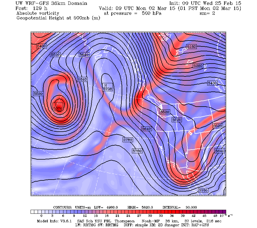
As I noted in an earlier blog, the ridge has not gone away, just shifted a bit westward. The upper level map for 1 AM Monday illustrates this. This ridge position allows weak disturbances (troughs) to pass southward through the Northwest. But these troughs will only bring brief periods of clouds and precipitation (roughly a day) before sun comes out again. In fact, this weekend looks sunny.
Finally, here is a high-tech ensemble-based prediction of cloud cover over Seattle from the North American Ensemble Forecasting System (NAEFS). Cloud cover goes from 0 to 10 (completely cloudy) and the dates are on the bottom. The horizontal black line shows the median (middle) value of the ensemble of forecasts. We have a cloudy period coming on Thursday and Friday, followed by sun over the weekend. Ups and downs, but we don't stay clouded in for long.
Rider Oasis Questionnaire
A group of bicycle enthusiasts are developing the idea to place convenient kiosks around the city with items of interest to cyclists. They have a questionnaire available on their website. Please take a look and give them feedback if you have a minute...thanks.
The Pacific Northwest Weather Workshop
Interested in attending the big local weather workshop of the region? The Pacific Northwest Weather Workshop will be held in Seattle at the NOAA facility on February 27-28th. Everyone is invited and the majority of talks are accessible to laypeople. To attend you have to register or they won't let you in the gate. There will be a major session on the Oso landslide. There is a registration fee that covers refreshments and food, and special student pricing. If interested, check out this website.

.jpg)


No comments:
Post a Comment