One of the unfortunate aspects of Northwest weather is that west of the Cascade crest, June is often a cloudy, gray month. Generally not much precipitation, but many days of low clouds. June Gloom. Here is a sample of the typical murk. Lots of stratocumulus, our signature June Gloom cloud.
But as shown by a picture from the Space Needle this AM, this June has been a very different animal, one of sun and warmth. July or August weather in June. A climate as close to perfect as one can imagine.
But you come to this blog for hard numbera, so let me give them to you! Here is the average number of cloudy days for each month at several Northwest cities. A cloudy day is defined as having 80% or more coverage of the sky. This data is from the Western Region Climate Center.
In June, Seattle Tacoma Airport typically has 17 cloudy days, with most of the remainder being partly cloudy. Quillayute, on the coast generally has 20. This is why vampires like Forks and other NW coastal locations.
But what about this year so far?
From official National Weather Service observations, Seattle Tacoma Airport only has had 4 cloudy days so far and from the forecasts it is clear that cloudy days will be hard to find the rest of the month. The bottom line: June 2015 will only have roughly ONE QUARTER OF THE NORMAL NUMBER OF CLOUDY DAYS. 4 or 5 cloudy days compared to 17.
But are you REALLY prepared to be impressed?
Quillayute Airport on the NW WA coast typically has 20 cloudy days. This year? ONLY 3. You read this right. Only three cloudy days on the normally stratus-bound Washington Coast. You can imagine the impact on local vampires.
Want more. Yakima typically has 10 cloudy days per month in June. How many have they had so far? ZERO.
An amazing month. Probably the sunniest month in Northwest history.
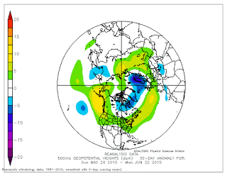
The reason for all this sun? The upper-level circulation pattern has been very anomalous the past 30 days, with higher pressure over the eastern Pacific. Here are the upper level (500 hPa, around 18,000 feet height anomalies) for the past month. Much higher than normal heights over the eastern Pacific (yellow colors) are evident, with some these higher heights extending over our region. And the temperature of the Pacific Ocean is much warmer than normal...that works against low clouds as well.
We are about to experience a major warm up, with temperatures rising into the mid-80s to near 90F in western Washington, and highs reaching up 105F east of the Cascade crest. Lots of sun. But there will be thunderstorms and the risk of lightning-caused fires.


No comments:
Post a Comment