This afternoon you can expect very strong winds over NW Washington and along the coast, with gusts to 40-60 mph (see the forecast of sustained winds at 1 PM from the UW WRF model).
Wind gusts at Smith Island over the eastern part of the Strait of Juan de Fuca are already (11 AM) reaching 50 knots....and they are still increasing (see below)! These are southeasterly winds, resulting from the interaction of strong southerly winds with the Olympics.
Winds could gust to 40-50 mph around Seattle, particularly near the water. You might want to go to sleep with a flashlight handy.
The freezing level is relatively low right now (about 3000 ft) and with plenty of precipitation from this system, there will be substantial snow today, certainly above 3500 ft. Then the temperatures cool behind the low (northwesterly flow follows) and we will move into a cool, showery regime with moderate snow in the mountains.
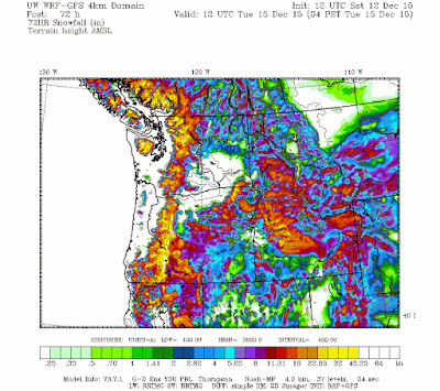
Here is the forecast 72-hr snow total for the next three days. We are talking of several feet of snow in the Cascades and Olympics. Very good for skiers. This period will guarantee skiing over the holiday break. And really good in increasing the snowpack for water resources next year.
The forecast models have a crazy strong storm forecast for later next week...but this is too far out to have much confidence. Stay tuned.


No comments:
Post a Comment