More and more snow, with no rain periods. Deep soft snow. Little ice.
But good times are over. A warm, wet atmospheric river is upon us. And Cascade Concrete is about to return.
The latest WRF model forecast for the 24-h total precipitation through 4 PM Thursday, shows moderate to heavy precipitation over our region, with over 5 inches in some portions of the Olympics and north Cascades
This precipitation is the result of a relatively narrow plume of moisture coming out of the subtopics....known as an atmospheric river. Below is a forecast of the vertically integrated water vapor for 4 AM--the total amount of water in the vertical. The atmospheric river (red and white colors) is obvious.
The infrared image at 9 PM Wednesday night shows substantial clouds with the atmospheric river, with moisture streaming from the SW to the NE.
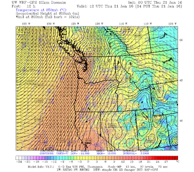
The atmospheric river is associated with strong winds and quite warm temperatures. Here is the forecast 850 hPa (about 5000 ft) for 4 AM Thursday. The orange colors shows the warm air. The snow will rise to around 7000 ft today....well above the passes. Initially, cool easterly flow will keep snow falling in the passes, but sometime today the strong, warm flow will win and rain will fall on the snow.
If you mix lots of snow with warm temperatures and heavy rains, what do you get?
Avalanche threat. Particularly in the north Cascades, where the rain will be very heavy. My colleagues at the NW Avalanche Center have serious warnings out (see below). Be very careful in the backcountry for the next few days.
More rain on Friday...sorry.


No comments:
Post a Comment