But it is all going to end this weekend, with cool, showery weather settling in for an extended period.
Real meteorologists prefer to look at the output of ensemble forecast systems that present the results of many predictions. Here is the graphic from the North American Ensemble Forecasting System. Warming through Friday...and then bang... an extended cool off, with increased chances of precipitation and clouds (the yellow boxes show the range of the middle 50% of the ensembles, the "whiskers" indicating the range of the predictions.
The latest 6-10 day predictions of the National Weather Service Climate Prediction Center? Cool and wet over the region.
The precipitation total for the 72h ending 5 PM on Tuesday? Wet!
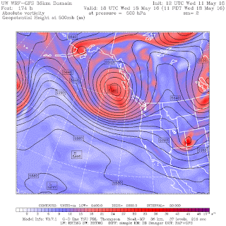
Why the change? The high pressure area over the West Coast is going to ridge heaven. For example, at 5 PM Saturday, an area of low pressure is over us, with the ridge pushed inland (at 500 hPa, about 18,000 ft). Cool.
So if you want to enjoy a sun-bathed walk in the park, do it during the next few days. Thinking about planting some grass or a plant in your garden. Do it NOW! You won't have to water much.


No comments:
Post a Comment