Announcement: Climate Surprise Talk
During the evening of September 28, I will be giving talk in Seattle at UW's Kane Hall on Climate Surprise: Unexpected Impacts of Global Warming on the Pacific Northwest. This will be a new talk, based on the latest research, that will describe some regional "climate surprises" that may well occur in our region during the next century. This talk is sponsored by CarbonWa and the Audubon Society To find out more or to secure tickets, please go here.
_________________________________________
During most summers it happens around this time: the first major transition to cooler temperatures. Generally, during the third or fourth week of August, a strengthened jet stream undulates southward over us, bringing much cooler temperatures and some light showers. And this year is no different.
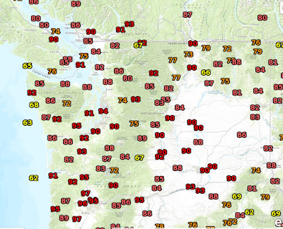
But we have one more day of very warm temperatures reaching into the 90s on Friday, before the weekend transition begins. Yesterday (Thursday) was quite toasty west of the Cascade crest, with temperatures reaching the 90s as far north as central Puget Sound. Even the coast was warm as a result of general easterly flow aloft.
With high pressure still dominating the region, tomorrow should be equally as warm away from the coast, so don't thrown away the sunscreen and sunhat yet. The UW WRF model forecast of surface temperature fro 5 PM Friday shows warm temperature over the western interior, but if you look closely you can see the onset of onshore flow, that will begin the cooling process on the coast before it spreads inland Saturday.
Over the weekend, the ridge of high pressure will move westward, with a series of troughs (low pressure) over increasing amplitude pushing into our neighborhood. Let me show you using a series of upper level (500 hPa, about 18,000 ft) maps.
Thursday at 5 PM. BIG RIDGE over the eastern Pacific.
Saturday at 11 AM PDT, a sharp trough is pushing towards us from British Columbia.
11 PM Tuesday, troughing amplifies off the NW coast
5 AM Friday. WOW. Very deep low right off our coast.
A feature this strong will bring rain back to the Northwest. Here is the 72hr total precipitation ending 5 AM Friday. Light to moderate totals over western WA and Oregon. More in BC.
The Climate Prediction Center's 6-10 day forecast is going for below normal temperatures and above normal precipitation.
So enjoy today's warmth and sun and be prepared for a progressive cool down to below normal temperatures by Sunday, extending into next week. You might want to find that sweatshirt and umbrella that are gathering dust in the corner.
The European social model is a common vision many European states have for a society that combines economic growth with high living standards and good ...
Subscribe to:
Post Comments (Atom)


No comments:
Post a Comment