Yesterday, the temperatures rose into the mid-sixties at many locations of western Washington and the upper 60s in the portions of eastern WA (see map). Seattle's high of 65F was more appropriate for late September than dark, wet November!
As shown by a plot of temperature at Seattle Tacoma Airport, our temperatures (particularly the minimum temperatures) have been above normal for several weeks, with some impressive maximum temperature spikes to well above normal. Today (Friday) will bring another temperature spike.
Perhaps surprisingly, this warm period has also been accompanied by much wetter than normal weather, with record-breaking precipitation over the State, something I have talked about extensively in previous blogs.
It turns out that there is a direct connection between the warmth and wetness we have experienced, something I will demonstrate in this blog. Both are caused by the same basic flow configuration.
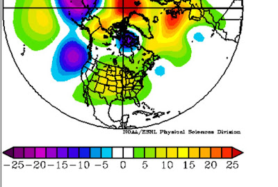
What is that flow configuration? Here is the anomaly from normal conditions (climatology) for upper level (500hPa) heights (like pressure) for the past 7 days. Purple and blue indicate lower than normal heights, yellow and red, above normal. Note that there is a large negative anomaly (low heights or troughing) off our coast, with higher than normal heights over most of the rest of the country. Since air moves counterclockwise around low centers in the midlatitudes, this flow configuration is associated with enhanced southerly/southwesterfly flow along the West Coast. Such a southerly flow brings subtropical moisture and warmth into our region.
To illustrate this, here are the heights (solid lines), winds, and temperatures (shading) at 850 hPa (about 5000 ft) for 11 AM today (Friday). You can see the deep low (trough) over the northeastern Pacific and higher heights (ridging) inland. The winds are from the south/southwest over us. As evident from the shading, the warmth (red colors) is being brought northward into the Pacific Northwest by this flow pattern.
Now, if the low is a bit farther offshore (like today or yesterday), we get the warmth but not the rain. In addition, easterly flow aloft gives us downslope flow and a further surge of temperatures. If the low is displaced a bit to the east, we get into the stronger, moisturer southwesterly flow (often an atmospheric river), which brings clouds and precipitation, often heavy. The satellite picture at 11 AM Friday shows how close to the edge we are, with some higher clouds extending over our region...but the real action offshore.
The story of our fall has been this offshore trough and inland ridge, with our weather gyrating between warm and very wet. Tomorrow (Saturday) we will be back in the wet! Enjoy.
_________________________________________________
I-732 is perhaps the most important ballot measure in decades, please support it.
I-732, the revenue-neutral carbon tax swap, will help reduce Washington State's greenhouse gas emissions, make our tax system less regressive, and potentially serve as a potent bipartisan model for the rest of the nation. More information here.
Some opponents of I-732 are spreading false information, suggesting that I-732 is not revenue neutral. This claim can be easily disproven as discussed here.
I strongly support I-732 as do many UW climate scientists. We have an unprecedented opportunity to lead the nation in reducing carbon emissions and to establish a model that could spread around the country.
The European social model is a common vision many European states have for a society that combines economic growth with high living standards and good ...
Subscribe to:
Post Comments (Atom)


No comments:
Post a Comment