
Landslides are generally associated with a periods of sustained above-normal precipitation that leads to saturated soils. With saturation in place, surface-based slides then occur after a short period (6-24 hr) of particularly intense precipitation.
The regional landscape is now primed for landslides after an extraordinary period of above normal precipitation, with many locations having experienced their wettest October on record.
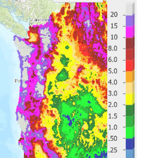
The percentage of average precipitation for the last 30 days (see below) is amazing, with most of the region about 200% of normal and about half greater than 300% of normal.

A number of minor landslides have already occurred from this period ofheavy rain, such as the recent slide on Marine View Drive in Tacoma (State Highway 509)

Washington's State's Department of Natural Resources has a real-time landslide warning map that combines antecedent precipitation, forecast precipitation, and slope/soil information to provide landslide warnings (see below). The website for this map is found here.


And with tropical air comes warmth, as shown by this forecast of temperature at 5000 ft for 4 PM Monday. Red and orange is warm.


And yes, don't forget to vote. If we don't start reducing carbon emissions, such weather (and precipitation) will be normal by the end of the century. That is why I-732 is so important.


No comments:
Post a Comment