Thursday, September 11, 2014

A Very Warm Autumn and Winter Ahead?

Combine the blob of warm water over the northeast Pacific and a developing El Nino and what do you get?

Potentially one of the warmest autumns  in years.

And this is exactly what the National Weather Service's long-range forecasting system is predicting.

We start with "the blob", the highly persistent area of warm water west of the Northwest coast (described in my previous blog).   The sea surface temperature anomaly (difference from normal) for the first 8 days of September are shown below.  You can see the warm water off our coast.

Since the air that reaches the Northwest comes off the Pacific,  you don't have to be a meteorologist to understand that they will tend to warm our area.  The warm blob has been very persistent and will certainly remain in place for the next month or two.

And then there is the developing El Nino (associated with warmer water in the central and eastern tropical Pacific).  Here is the latest prediction from the NOAA/NWS Climate Prediction Center.  Roughly an 65% chance of El Nino this winter.


 And what do El Ninos typical favor in the Northwest?  Warmer than normal temperatures. Here are the typical temperature anomalies (from climatology) for some previous El Ninos... the orange/red colors are above normal


So we have both the warm blob and El Nino working together for warmth.

But what does the National Weather Service's fancy Climate Forecast System (CFS) say?  A sophisticated coupled ocean/atmosphere combination that takes everything into account?  Here are the air temperature anomalies (right above the surface) for  October-November-December.   Warm.

The El Nino should rev up during the winter and here is the December, January, February prediction...much warm than normal (1-2 C, 2-4F).
I am not going to say anything about whether you should get a season pass to the lower ski areas in the Cascades.  Last time I did so I got complaints from certain people.

And what about the official Climate Prediction Center forecast for this fall? (see below).  Not surprisingly warmer than normal.


The rest of the winter looks the same.


Is a warm fall and winter guaranteed?   Of course, not.  But the meteorological dice are heavily weighted in this direction.

Particularly, when these two folks below combine forces.


Tuesday, September 9, 2014

Did "THE BLOB" cause our warm summer?

This has been an unusually warm summer here in the Pacific Northwest.  But why?

Several people have suggested the cause is a pool of unusually warm water over the northeast Pacific, one my colleague Nick Bond has amusingly  termed "the blob."   How did this blob develop and what are the implications?

As noted above, the blob is a region of unusually warm water off the Northwest coast.  Here is the difference from normal sea surface temperature (the SST anomaly) for this summer (courtesy of NOAA).  Can you see the orange area off our coast, that is the "blob".  It represents an area of water about 2-3 C warmer than normal.

The blob developed last fall and early winter, as illustrated by the sea surface temperature anomaly maps for September 26, 2013 and January 23, 2014, shown below.


But why?

The warm blob developed last winter as a result of the unusual persistence of high pressure over the eastern Pacific.  Here is difference from normal for sea level pressure for Sept to December 2013.  WOW!   A huge anomaly with the pressure over the northeast Pacific being over 6 millibars (aka hPa) above normal.  Folks, that is a big anomaly.  And it was associated with our dry fall and early winter last year.
Nick has analyzed the impacts of this high pressure area; one associated with far less storminess than normal (storms are generally associated with low pressure regions).  With less storminess, there were fewer waves and less mixing of the upper Pacific, mixing that tends to bring up colder water from beneath the surface.   Thus, the surface layer of the ocean ended up several degrees warmer than normal and this anomaly persisted into the spring and summer.

So now you know the origin of the blob: the impact of unusual fall high pressure.  But how does that warm the air over us?

During the summer, the East Pacific High builds northward in the eastern Pacific and the air that reaches us on the typical summer day comes off the Pacific.  To prove this, here is the trajectory of air ending over Seattle on August 29th.  It was over the blob a few days earlier!


The temperature of the low-level air is greatly influenced by the sea surface temperature and thus warmer water tends to cause the air reaching us to warm.    The temperature anomaly of the blog is 2-3C (roughly 4-5F) , which is quite similar to the degree of warming above normal this summer over much of the Northwest (see graphic)


A number of you have complained about the humidity being unusually high this summer.  Blame the blob.  Warmer air can acquire more water vapor than cooler air and the amount of water vapor air can hold increases VERY rapidly with temperature.

There is, of course, a lot of interest in whether the warm temperatures this summer were associated with global warming.   It does not appear so.  The warming was caused by anomalous high pressure over the eastern Pacific last fall and there is no reason to believe that has anything to do with warming the planet from the greenhouse gases mankind emits.

One final note:  the persistent warm air was a bonanza for extended range weather forecasters.   With the warm water holding in place, our long-range computer models, such as the Climate Forecast System (CFS) accurately predicted the warm summer months earlier.  Don't believe me?  Here is the proof: the June-July-August surface temperature anomaly forecast made in March!  The reds are 1-2 C warmer than normal.  Impressive skill.


Monday, September 8, 2014

Model Casting Call - Magazine Model Search 2014 Model Of The Year Contest


Model of the Year 2014 Magazine Model Search


The time to take your modeling career to amazing new levels is here!


Submit yourself today for your shot to be featured in a Christmas issue of Ripping Runways Magazine, Girl 9 Magazine for Men, or Salon Savvy Magazine 2014 Model of the Year Contest.


This is an International 2014 end of the year Model Search for all three internationally known magazines, and we are searching for the hottest models worldwide to feature in Ripping Runways Magazine Christmas Issue, Girl 9 Lingerie Magazine Christmas Issue, and Salon Savvy Magazine Christmas Issue.


We will select a beautiful, hot, and sexy model for each magazine for the Christmas issues as the 2014 model of the year, and all magazines will be online just in time for the Christmas holidays, and if you are a hot and sexy female model looking to expand your modeling portfolio internationally, with online magazines that have created a strong presence in both the entertainment and fashion industry, then you will want to submit yourself to this casting call for a chance to be a featured model in one of these hot magazines, which will expand your modeling portfolio, give you international exposure, and an opportunity for you to be seen by thousands of people, including fashion and entertainment insiders, which could possibly result in paid modeling jobs, TV castings, Trade Show jobs, or other great opportunities in the fashion and entertainment industry.


All three magazines are now casting for the hottest female aspiring and professional fashion models, print models, hair models, bikini models, fitness models, eye candy models, vixen models, exotic models, makeup models, and lingerie models ages 18-35, and we are looking for a select group of Asian models, Indian models, Hispanic models, Black models, Russian models, European models, Dutch models, African models, French models, and Bi-racial models worldwide and there are no height requirements or fees, to enter this 2014 Model of The Year Contest.


If you are a beautiful model that has a recent hot professional portfolio or photo shoot of 12 or more high resolution photos with no writing or logos on them and you are serious about being featured in an internationally known magazine, then this is your big chance and the opportunity of the year for you to be seen and promoted worldwide in one of our internationally known publications that are read by thousands of people and industry insiders that are always looking for fresh new faces and aspiring models.


To apply for consideration as a feature female model in one of these magazines, please submit 12 or more recent professional high resolution photos that are no older than 12 month and not posted on any other website online, and also submit a professional written bio with your contact information to us by email.


The more photos you submit, the better chance you will have of being selected to be a featured model in one of the

2014 Christmas Model of the Year Issues.


We do not accept photos that are older than 12 months, we do not accept camera phone photos, we do not accept photos with more than one model in it, we do not accept photos posted on other websites, we do not accept low resolution photos, we do not accept photos with writing on them, logos, or photographer signatures, and we do not accept personal photos that are taken in your home, we do not accept photos that are collages or have effects, or have borders added to them, so please do not submit none of the above or your photos will not be considered as a possible feature.


This is one modeling opportunity you don’t want to miss if you are serious about taking your modeling career to the next level.


Please read Casting Call Carefully:


You must visit one of our websites below

To fill out an audition form:


Salon Savvy Magazine Web Site:


Ripping Runways Magazine Web Site:
http://rippingrunways.wix.com/rippingrunways


Girl 9 Magazine Web Site:


Konscious Money Entertainment Group Web Site:


You can read our magazines at:


Girl 9 Online Magazine:


DO NOT APPLY FOR THIS CASTING IF YOU DO NOT HAVE

12 OR MORE RECENT PROFESSIONAL HIGH RESOLUTION PHOTOS WITH NO WRITING ON THEM THAT ARE NO OLDER THAN 12 MONTHS.


Sunday, September 7, 2014

EPA Takes on the Oyster/Acidification Scaremongers

It's been a convenient story for some.

The "evil twin of global warming", ocean acidification caused by increasing carbon dioxide, is killing billions of oysters in Northwest waters.

Major media gave it lots of play, with the Seattle Times producing a glossy series centered around the oyster carnage.  Just a short excerpt from the scary ST story


Even the New York Time recently gave it front page coverage.

But there was a problem.

It really wasn't true.  There is no evidence that ocean acidification is damaging oysters in Puget Sound or other local waters.

Who says so?  The U.S. Environmental Protection Agency and the State of Washington.


Recently, in a formal legal statement provided to the U.S. District Court of Western Washington, the U.S. Environmental Protection Agency  (EPA) made it clear that the oyster/acidification scare was baseless in both fact and law.   Furthermore, the Washington State Department of Ecology came to the same conclusion.

Here is a sample from the EPA document (Page 18, lines 8-12)

"There were no in situ field studies documenting adverse effects on the health of aquatic life populations in either State. Nor was there any other information documenting effects on indigenous populations of aquatic life in State waters indicating stressors attributable to ocean acidification. The only information available regarding aquatic life in ambient waters under natural conditions was inconclusive."

And here is an example of what Washington State's Department of Ecology had to say about this issue:

“None of the documents included data that showed any data outside of the accepted range [7.0-8.5], and in particular, no data demonstrated a decline in pH at any Washington marine water body of greater than 0.2 or 0.5 pH units (depending on the waterbody use designation) due to a human-caused variation within the accepted range.” 

You might rightfully ask: why did oysters and acidification get into the legal arena?


 Because a environmental advocacy group, The Center for Biological Diversity (CBC), filed a Complaint For Declaratory and Injunctve Relief against the EPA.  The complaint is found here.  Let's follow their own words:

"Shellfish in Washington and Oregon are experiencing a dramatic collapse in production. Beginning in 2005, billions of  oyster larvae have perished in the Pacific Northwest hatcheries that raise young oysters in the region’s seawater, with some hatcheries losing up to 80 percent of their larvae."
...Acidified waters are already reaching surface waters along the Washington and Oregon coasts. As a result, marine organisms in the Puget Sound and along the Pacific Coast are exposed to corrosive waters. Scientists have definitively linked the oyster production problems in the hatcheries to ocean acidification. ...
For these reasons, Plaintiff seeks declaratory and injunctive relief requiring EPA to partially disapprove of Oregon and Washington’s impaired waters lists and add water bodies impaired by ocean acidification to those lists. 

Much of the CBC injunction is obviously false, such as their claim that waters are becoming "corrosive" or that oysters are dying in the natural environment. The EPA response, based on peer-reviewed science and direct observational evidence, shows that CBC arguments are without any basis in fact.  Some samples from the EPA document:

EPA explained that there was no evidence of impairment based on non-attainment of Oregon's water quality standards applicable to ocean acidification  (Pg 8, lines 23-24)

We have reviewed each of the documents referenced by CBD as support for their assertions....none of the document include data outside the accepted range...due to human-caused variation (Pg 12, lines 11-16)

There was one study, heavily cited by CBF and acidification activists by Wootton et al (2008) for one site on Tatoosh Island.  EPA has analyzed this paper in detail (example found here) and a summary of the EPA conclusions are found in the EPA response:

 ... the study does not provide conclusive evidence that the cause of the pH change is due to human sources. For instance, the change could be caused by natural sources related to inputs from river discharges, long-shore shelf transport and planktonic specifics composition (i.e., the pH changes could be related to changes in physical conditions due to the location and changes in the patterns of primary productivity and species composition)


Regarding the same Wootton study, the Washington State Dept of Ecology stated:

This study does not provide any pH data showing impairments of Washington 
waters, nor does it provide conclusive evidence that Washington’s coastal aquatic life in the 
natural environment are being impaired by ocean acidification

Another major study cited by the CBD and acidification activists is Barton et al. (2012).   EPA's analysis:

The Barton Study included no data regarding the health of wild aquatic organisms, and the only pH data presented in the Barton Study indicated a pH in Netarts Bay between 7.6 and 8.2, both within the acceptable range of 7.0-8.5 for marine waters and 6.5-8.5 for estuarine waters.

I could spend a lot more time giving you samples form the EPA or Washington State documents, but the bottom line is that when compelled to provide testimony in court, both agencies revealed that their analysis of observations, the literature, and basic principles compelled them to conclude that there is no evidence that ocean acidification is causing any problems for oysters in the natural waters of Oregon and Washington.

As many of you know, I agree with EPA and Washington State and have blogged with my own analysis (here and here).

The most irresponsible coverage of the oyster-acidification link has been in the Seattle Times Sea Change series.

But what is the attraction of pushing a connection between oysters and acidification that is so easy to question?

Much of it reflects the search for those concerned about global warming to find "a canary in the coal mine" that will get people motivated to take serious action.

Anthropogenic (human-caused) global warming is a serious issue.  The earth is going to warm in a major way due to increasing greenhouse gases.  But most of the significant changes will occur in the future.  And the recent "pause" in warming has been a field day for skeptics.

It is REALLY hard to get people to make major sacrifices or change their life styles NOW, to avert a threat in the future.  As far as I know, the only example of such action is the Pharaoh heeding Joseph's warning about an upcoming drought!

So with warming stalled and natural variability still large compared to the greenhouse warming, some environmental activists were attracted to the ocean acidification issue. CO2 is killing oysters NOW!  We must act to reduce CO2 now to save the oysters and shellfish!  Very convenient.   And to use this tool they were willing to stretch the truth or even to tell tall tales they had to know were inaccurate.

Some green politicians were also happy to use the oyster tale for their advantage and newspapers like the Seattle Times thought it was their route to a quick Pulitzer.  Local shellfish companies (some of whom privately admitted to me  that things were all hyped up and that my technical facts were quite correct) pushed the issue in public, since their industry received huge attention, and government grants to deal with "the problem" were flowing.   And yes, some folks in the academic community enjoyed grant largess from the issue.

Some tall tales are ok, Some are counterproductive

But I will argue that scientists must tell the public with unvarnished facts, whether convenient or not. And telling tall tales, even with good intent, is in the end counterproductive.   It provides skeptics and denier types easy ammunition to take down the environmental movement.

Let me end by saying how disappointed I have been in the Seattle Times.

When I wrote my blog criticizing the science in their story, they went on the attack and put up a response to my blog on their glossy site.  They said I "ignored the science", which seems kind of strange since my blogs were ALL ABOUT THE SCIENCE.


I asked for a chance to provide my response on their site.  They refused.

Well, now it is clear that the Seattle Times and EPA/State of Washington are on different sides with respect to the science.

But it is worst than that.  The Seattle Times also started to boycott talking to me.  If you do a search on their web site you will notice that I talked to their reporters about weather issues or my blog was quoted many times each year before I spoke out.  That all changed after I criticized their oyster death story.  If you want proof of this, go to their online archives and search on my name.

This is one reason I have this blog ...I can speak the truth without worrying about being cut off.  Even if it is inconvenient for some.

Finally, let me note that the fixation on the ocean acidification angle has reduced attention for far more serious threats to our local waters, like massive nutrient ejections into our water by our sewer systems, agricultural run off, and disturbances to the shoreline environment.


No one has seen to have told the local clam population that local waters are "corrosive" and deadly to shellfish.

Friday, September 5, 2014

Warm and Dry in Seattle, Cooler and Wet in San Diego

Sometimes the world seems upside down.

These weekend Seattle will be warm and dry with temperatures 10F and more above normal.  Some of you might see 90F.

At the same time, San Diego, a place with the average rainfall of Yakima, will be preparing for an unusual onslaught of moisture from Tropical Cyclone Norbert.  The latest infrared satellite picture (9:30 PM Friday PDT) shows the storm off southern Baja California and moisture streaming northward in advance of it.


This moisture will reach the San Diego area tomorrow, greatly increasing the chance of strong thunderstorms, particularly over the mountains east of the city.    Take a look at the cumulative precipitation over the next 78 hr (through 11 PM Monday).  The Northwest is practically the driest place in the nation.  But you can see the impacts of Norbert over the the Southwest, with 2-3 inches reaching the San Diego area.  Not the weather that surfer folks like!


Around here you can expect a further warm up in western Oregon and Washington.   Here are the max temps on Friday. 90s in the Willamette Valley.   Lower 80s in southern Puget sound, and 70s over NW Washington.  Add 5-10F tomorrow.


There is no better tool for warming periods than UW Probcast and here is the forecast from that system for Seattle.    86F tomorrow and a modest cool-down to 81F on Sunday.  Temps will be warmer on the eastside of Puget Sound


This warm-up is being aided by easterly offshore flow that isolates us from the cool waters of the Pacific and which produces compressional warming as the air sinks on the eastern slopes of the Cascades. You can see the easterly flow in this plot of winds above Sea-Tac Airport (temps are shown in red).  The x-axis is time (increasing to the left) and the y axis is height in pressure (850 hPa is around 5000 ft).  A thin veneer of northerlies near the surface with easterlies aloft.


A series of weak upper troughs will approach late Sunday and Monday resulting in a marine push and cool down.  But don't worry, the ridge will be back later in the week.

Folks in San Diego will be flying up here for dry, warm conditions.   You've got to feel sorry for them.

If anyone is interested, I will be doing a weather segment on SandBox radio...the Seattle version of Prairie Home Companion.  Will take place at ACT Theater, downtown Seattle, this Monday evening (Sept 8).   To spice it up, Steve Scher will be on the program as well!  No dueling will be allowed.  For more information: check here.

Wednesday, September 3, 2014

Super Convergence Zone Produces Blackouts and Flooding in Puget Sound Country

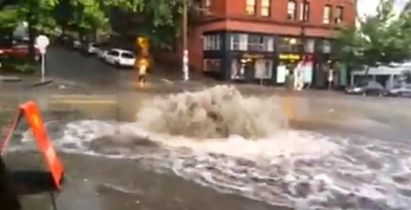
Convergence zones are generally benign affairs, with a band of clouds and precipitation across central Puget Sound, but Tuesday's convergence zone was a vigorous one with torrential rain, lightning, local flooding, and blackouts for thousands of customers, particularly in Seattle.  In fact, at one point, much of northeast Seattle was blackened out, including my own home.

And its impact was enhanced by it occurrence during the beginning of the fall weather season.

 A scene from Pike Street on Seattle's Capital Hill

Photo Courtesy of Cameron Bruce

A fast moving front/trough moved through the region Tuesday, with the winds turning westerly on the coast; the result was the development of a Puget Sound convergence zone as westerly winds pushed eastward north and south of the Olympics and converged over Puget Sound.


The result was an intense band of precipitation in the convergence as illustrated in this radar image at 6:18 PM Tuesday.  The reds are pouring, heavy rain.


The 6-hr rainfall ending 7:16 PM from Seattle Rainwatch  reached .5-1 inches in places (see total below), but the most damaging aspect was the precipitation intensity as the convergence zone moved buy, with several tenths of an inch falling in minutes. Preliminary data shows Myrtle Edwards Park receiving 0.73” in 30 min and Sand Point getting 0.61”in 30 min.  These are extraordinary rainfall rates for around here.  The street in front of my home (near Sand Point) was a river for 10 minutes.


Although our region get plenty of rain in the winter, it is generally light.   Intense convective rain is often too much for our drainage systems that are generally not configured to take large amounts in short periods.

To illustrate the amazing sharpness of the convergence zone, here is the record at the University of Washington of its passage.  Time is in UTC (GMT), with 0000 UTC being 5 PM.  The 6th panel is precipitation....the trace went straight up by around .2 inches in a few minutes.  You can see the sudden drop in temperature (third panel) and the sudden shift in the wind direction (second panel).

 Amazingly sharp transition.

Note that that wind gusted to about 25 knots BEFORE the convergence zone passage.  That is what led to so many power failures.  Here is a map of max winds yesterday around Seattle (mph).  Gusting to the mid-20s over land and into the 30s over the water.


Seems like kind of wimpy winds to cause power failures, right?   We would laugh at such winds during the mid-winter.   But this is the first storm of the season.  Trees have their leaves (which act as sails) and all the new growth since last winter has been untested by wind.   The first event syndrome.

(As an aside you got to really appreciate the power line crews working to restore power in the rain after this kind of event--these folks are heroic, working in the rain and adverse conditions to get the power back on!)

Finally, a convergence zone subtlety for those who appreciate such things.   The strongest winds with convergence zones are often in the southerlies/southwesterlies south of the convergence line.   To show this, here is a wind forecast for 5 PM from the UW WRF model.  The yellows are sustained winds of around 20 kts (not gusts, which would be larger).  If you look closely, you can see the wind barbs that provide the directions.  Solid lines are sea level pressure.   Very good forecast by the way.

So why are winds so strong south of the convergence zone (where the northerly and southerly winds are colliding?).   The answer is in the pressure pattern.  As the winds from off the Pacific (westerly and northwesterly) interact with the Olympics, the result is an area of low pressure (a trough) east of the Olympics.  Think of water sluicing downwards on the downstream side of rock in a river.   You can see the trough in the pressure forecast above.   This pressure pattern creates a pressure difference (or gradient) over the the south Sound that accelerates winds to the north (air speeds up went it goes from high to low pressure).

This forecast drove a very skillful warning to Seattle City Light on their WindWatch application, giving their crews a heads-up to be ready.

If anyone is interested, I will be doing a weather segment on SandBox radio...the Seattle version of Prairie Home Companion.  Will take place at ACT Theater, downtown Seattle, this Monday evening (Sept 8).   To spice it up, Steve Scher will be on the program as well!  For more information: check here.

Monday, September 1, 2014

A Summer for the Record Books

The National Weather Service has released the latest climate statistics for August, and the combined July/August temperatures are really amazing.

Seattle had its warmest July/August on record.

PUBLIC INFORMATION STATEMENT
NATIONAL WEATHER SERVICE SEATTLE WA
500 AM PDT TUE SEP 2 2014

..WARMEST JULY AND AUGUST ON RECORD IN SEATTLE...
..SECOND YEAR IN A ROW WITH A WARM MIDDLE OF THE SUMMER...

THE AVERAGE TEMPERATURE FOR JULY 1ST THROUGH AUGUST 31ST THIS YEAR
IN SEATTLE WAS 69.2 DEGREES. THIS IS THE WARMEST AVERAGE TEMPERATURE
FOR THIS TWO MONTH PERIOD ON RECORD BREAKING THE OLD RECORD OF 68.8
DEGREES SET IN 1967.

This is also true at Spokane, Wenatchee, and Lewiston

Here are the numbers from the NWS.

SITE: SPOKANE (RECORDS BEGAN 1881)
JULY/AUGUST AVERAGE TEMP    YEAR    RANK
74.0                        2014    1
73.5                        1998    2
73.3                        1958    3
73.1                        2013    4
72.9                        1930    5
SITE: LEWISTON (RECORDS BEGAN 1881)
JULY/AUGUST AVERAGE TEMP    YEAR    RANK
78.5                        2014    1 (TIED)
78.5                        1939    1
78.1                        1898    3
77.9                        2013    4
77.7                        1906    5
SITE: WENATCHEE AIRPORT (RECORDS BEGAN 1959)
JULY/AUGUST AVERAGE TEMP    YEAR    RANK
78.9                        2014    1
77.8                        1961    2
77.3                        1998    3
77.0                        1967    4

76.7                        1971    5

 Olympia had their second warmest July/Augusts on record.

The record-loving folks among you will now turn to the official summer season ending on September 21st.  We are going to warm up later this week, so we have a shot at it.  Stay tuned.

Popular Posts