Thursday, January 22, 2015

Modeling Magazine Casting Calls 2015 - Fashion Week Casting Calls 2015


Magazine Model Casting Calls 2015


Project Couture Magazine and Out Next Magazine

High Fashion Male and Female Model Casting Calls 2015


The International Beauty Movement will be releasing two new online upscale fashion model magazines in April 2015, and they are entitled “Project Couture Magazine” and “Out Next Magazine.”


These two new magazines will be dedicated to upscale female and male fashion models worldwide ages 18-35, creative hair stylists, makeup artists, fashion photographers, clothing designers, fashion journalists, and fashion stylists worldwide.


This is one casting call you will want to submit your professional photo portfolio to if you are a male or female fashion model ages 18-35, creative hair stylist, makeup artist, fashion photographer, clothing designer, fashion journalist, or fashion stylist looking for the perfect opportunity to take your fashion career to the next level, showcase your fashion talent or work on a global stage, expand your fashion career, gain worldwide exposure for your talent in the fashion and publishing industry, expand your professional portfolio in the fashion and entertainment industry, and increase your opportunity of  having your talent or work recognized or being seen by thousands of people including fashion industry and entertainment industry insiders worldwide, then you will want to submit a recent professional photo portfolio of no less than 12 recent professional high resolution photos with no writing or watermarks and a professional bio with your contact information to the International Beauty Movement for an opportunity that could open door for you as an international magazine print model and create high paying jobs for you in the fashion or entertainment industry.


Konscious Money Entertainment Group, Creator of the International Beauty Movement has created a strong presence in both the entertainment and fashion industry with it’s internationally known Ripping Runways Magazine publication and Girl 9 Magazine For Men, Salon Savvy Magazine for Hair Stylists and Makeup Artists worldwide, and as a result, Konscious Money Entertainment Group, Ripping Runways Magazine, Girl 9 Magazine, and Salon Savvy Magazine is responsible for featuring some of the hottest and most beautiful female models and beauty pageant winners worldwide since 2012.


The International Beauty Movement is now accepting modeling portfolios from high fashion male and female models for a possible feature in one of these magazines that meet the following qualifications:


Please read Casting Call Carefully:


Male Models submitting themselves to this magazine casting call:
must be ages 18-35, height must be 5’10 or taller, must have a lean muscular build, have a professional look, be photogenic, very few if any tattoos, must have a fashionable hair cut, clear skin, facial hair must be neatly trimmed if you have facial hair, must submit a recent professional high resolution photo portfolio no older than 12 months with 12 or more professional high resolution photos in formal dress clothing and fashionable casual clothing with no photographer signatures or logos on them, must submit a professional bio with contact information, and if you have high quality video footage you may also submit it.


Female Models submitting themselves to this magazine casting call:
must be ages 18-35, height must be 5’7 or taller, female models must be in great physical shape and have a lean curvy body that looks great in lingerie, swim wear, fashionable casual clothing, and high fashion dress clothing, must have very few if any tattoos, clear skin no pimples or bumps, no body scars or stretch marks, must submit a recent professional high resolution photo portfolio no older than 12 months, must submit 12 or more professional high resolution photos in fashionable dress clothing, lingerie, swimwear, and or fashionable casual clothing with no photographer signatures or logos on them, must submit a professional bio with contact information, and if you have high quality video footage you may also submit it.


All photos submitted by models will be evaluated on creative posing, makeup and hair styling, photo shoot location, and unique look.


The more photos you submit, the better chance you will have of being selected to be a featured model in one of the 2015 upcoming issues of our magazine, so you will want to submit a lot of hot photos.


We do not accept photos that are older than 12 months, we do not accept camera phone photos, we do not accept photos with more than one model in it, we do not accept photos posted on other websites, we do not accept low resolution photos, we do not accept photos with writing on them, logos, or photographer signatures, and we do not accept personal photos that are taken in your home, we do not accept photos that are collages or have effects, or have borders added to them, so please do not submit none of the above or your photos will not be considered.


Please Feel Free To Visit Our Websites

and Read Our magazines At The Links Below:


International Beauty Movement Web Site:


Salon Savvy Magazine Web Site:


Ripping Runways Magazine Web Site:


Girl 9 Magazine Web Site:


Konscious Money Entertainment Group Web Site:


You can read our hot fashion magazines at:


Ripping Runways Online Magazine:


Girl 9 Online Magazine:


http://issuu.com/rippingrunways/docs/2014_girl_9_magazine_christmas_issu/1


Salon Savvy Online Magazine:


Please visit our casting call link to view all of our current casting calls for female models and stylists at: http://rippingrunways.blogspot.com/


Sea Fog and Lowered "King Tides"

Local weather enthusiast and the maestro of Skunk Bay Weather Greg Johnson sent me some impressive imagery and video of sea fog off of Point No Point on the Kitsap Peninsula around 8 AM yesterday (January 21st).  Click on the image or link to view it.


Why such a nice display of this shallow fog?

We start with relatively warm water......here is the sea surface temperature at the Orca buoy at Hansville, only a few miles away from the Point No Point lighthouse (I got this on the wonderful Nanoos website provided by the University of Washington).  The water was around 49F.

It turns out, that the air temperatures were relatively cold that morning,dropping into the mid 30s, as shown by the observations at Greg's Johnson's Skunk Bay Weather Site, which is quite close to Point No Point:


Same story at Port Townsend


So relatively cold air was passing over water, water about 12-15F warmer.  Moisture from the warm water was able to saturate the cold air (cold air can "hold" less water vapor than warm air) producing the shallow fog.   This kind of fog is also called "steam fog".

 The other big water story are the "King Tides" that will be occurring the next few days. Here is a plot of the predicted and observed tides.  They will be particularly high Friday and Saturday.  


But here is an interesting observation--the observed tides (red) are less than predicted (blue).  Why?

The reason is that atmospheric pressure is running higher than normal and high pressure pushes the water down, reducing the water level.  So perhaps we should call them "Queen Tides" this year.  A fascinating aspect of King Tide periods is that they give you a feeling what the typical tides will be in roughly 150 years from now due to global warming---if we let it happen


Tuesday, January 20, 2015

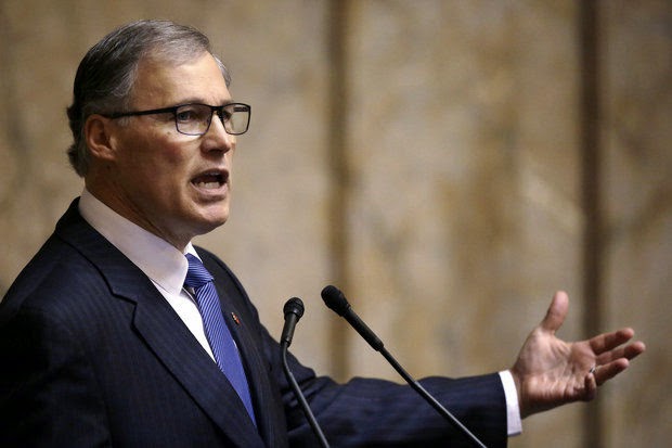
What Should Governor Inslee Do About Climate Change?

The press is full of coverage of Governor Inslee's proposed climate plan, revealing vast differences in the viewpoints of Democrats and Republicans, particularly about the controversial cap and trade program.
In this blog I will suggest an alternative plan, that might be acceptable to both sides of the aisle.  Maybe.

Our governor really cares about climate change....and he should.   Mankind is emitting huge amounts of carbon dioxide into the atmosphere and there surely will be serious climate impacts later in this century.   A few years ago as a Congressman, Jay Inslee visited the UW and several of us briefed him about some of the latest research findings.   I was impressed with his interest and passion in the subject...not your average politician.  How many politicians have written books on the climate issue, like Inslee's Apollo's Fire?  You got to respect his willingness to get in front of a major societal issue.

Washington Governor Jay Inslee

Recently, Governor Inslee announced a climate action strategy, centered around a one-billion dollar cap and trade plan.   And he has made several executive decisions to support clean energy.

But I am worried about whether his approach will be effective.   Recent changes in the makeup of the Washington State legislature have reduced the chances that any cap and trade plan will be enacted--and the success of cap and trade in other venues has not been impressive.

So if I was Governor, what would be MY program?

Here is my plan:

I.   Secure a better understanding of how our climate has changed during the past century and how it will change during the next 100 years.

 If our state is going to deal with climate change, we must understand what has happened and what will happen.  You can't make robust policies without solid information, right?   As a weather/climate scientist let me assure you there are major weaknesses in our knowledge on both counts--but with some effort we can fix the deficiencies.

Step 1: Strengthen the Office of the Washington State Climatologist (OWSC).

 OWSC has the responsibility to collect climate data for the State and to make it available to WA citizens and decision makers.  To provide a clear picture of previous changes in our state's climate.  This office is woefully underfunded (with a budget about 60K).   There is so much that they could and SHOULD be doing, but there is no funding.  The Governor and Legislature need to fix this.  Soon.

Step 2:  Begin an active program of regional climate simulation to get a far better understanding of the future regional implications of climate change.

To deal with Northwest climate change, it is essential to have reliable guidance on what will happen during the next century.   The guidance used today can be dramatically improved.  Global climate models do not produce consistent results about the regional implications of increasing greenhouse gases, and most of these models are far too coarse to consider the critically important terrain of the region.  To plan for the future, our state needs much better information, and there is a way to get it:  high-resolution regional climate models.    Secure a large number of global climate models and strain out the models that fail to get the current climate right.   Then run a  high resolution regional climate model for each global simulation to get the local implications (see sample below), and apply sophisticated statistical post-processing to provide calibrated regional climate predictions.

A regional climate prediction effort should be established immediately, with support from the State and others.  In  fact, a group of us have developed a plan to do so, found here.  Hopefully, we will be able to find some support for the effort.  The technology to secure far better future climate information is available and Governor Inslee should make regional climate prediction a top priority.   This could be highly bipartisan and would supply regional planners with the information they need for resilience and adaptation planning.

II.  Make our region more resilient to current conditions and future climate change.   

Step 3: Begin adaptation planning and infrastructure improvements.

Too many environmental activists look at adaptation as a dirty word, as if getting ready for future changes will lessen enthusiasm for mitigation (reducing emission of greenhouse gases).   But the truth is that our society is not sufficient resilient to the CURRENT climate  (e.g., the Oso landslide) and climate change will bring new stressors.   Substantial global warming is going to happen--we are simply not doing enough to stop it.  Therefore, the State and our Governor needs to make resilience and adaptation a priority--one that will pay great dividends no matter what happens.   What could be part of the Governor's resilience plan?

a.    Complete a lidar survey of the state to find all historical landslide locations.  Heavy precipitation is clearly going to increase under global warming and thus flooding and landslides will too.  Using the best advice of geomorphologists, our State must establish restrictions on new construction in vulnerable areas and begin the process of moving people from dangerous locations.


b.  Evaluate whether new reservoir capacity is needed in eastern Washington. Even today, there are years in which water for agriculture/fish is a problem;  what about 30-100 years from now?   There is already some discussion of expanding current reservoirs and/or adding new facilities.  A detailed examination of this issue, informed by the regional climate simulations noted above, is needed.    Beyond adaptation, should reservoir capacity be increased to allow a massive enhancement in eastern Washington agriculture to make up for the agricultural loses in increasingly drought-stricken California?  Folks need to eat.  Perhaps a huge opportunity for WA State agriculture.

c.  Considering the potential for increased river flooding, we must evaluate current development near rivers and begin the process of moving people away from vulnerable areas.  This may involve a buy-out program of some homes and businesses.  It also may include improved dikes and water works.

d.  Evaluate ways to lessen the impacts of sea level rise along the coast and near inland waterways.

In short, the State must begin a comprehensive evaluation of the threats to life and property accompanying global warming and then come up with and fund an explicit action plan to make the State less vulnerable for both current and future climate variations.  (see carbon tax below)

Everything mentioned above is relatively uncontroversial.   Now lets consider other parts of my climate plan.

III.  Deal with the regional transportation grid lock.

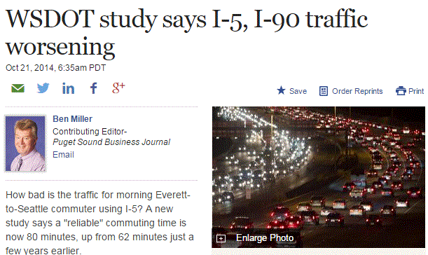
Few things waste more energy and provides more of an economic drain on the Puget Sound region, the economic engine of the State, then the worsening traffic crisis.   It is not only bad, but has gotten much worse in the last few years.  Unfortunately, regional political leadership has been extraordinarily ineffective in solving this crisis and the Governor needs to push the legislature and localities to get serious about transportation.    Consider just a few examples of local failures:

1.   As traffic has increased, King County Metro CUT bus service, with long wait and inadequate service on important commuter routes.

2.  Rail service north and south (Sounder trains) is not only infrequent but is often stopped, for days and weeks, by mudslides on the tracks south of Everett.  Here we have a nation that could put a man on the moon, but we can't seem to stabilize a few miles of slopes above the tracks.  Sad.

3.  The city of Seattle has let crucial bicycle routes deteriorate (e.g., the Burke Gilman trail) and has failed to establish a safe north-south route into the city.  Instead they are putting millions in a bicycle rental system (Pronto) that is barely used and has painted bicycle symbols on streets (sharrows).

4.  A wonderful north-south rail corridor on the east side (where 405 traffic is at a standstill all the time) is GIVEN UP for a recreational trail.  Imagine if fast commuter rail went in instead. How in the world did this happen.

5.  Seattle light rail south of Seattle does not have its own right of way and is amazingly slow as it gets stuck in lights or gets into accidents with motor vehicles.


I could list a dozen more examples, but the message is clear:  local politicians have been missing in action in dealing with regional gridlock.  The governor needs to deal with this.  Some ideas to start:

More buses and frequent service especially for important commuter runs.
Repair and extend bike trails
End the slide mess and add more Sounder trains.
Use Uber/Lyft/taxis for less traveled bus routes to reduce use of expensive large buses.
Expand light rail around Seattle, particularly by adding a line down I5 to the airport.
Add rail service to Stevens Pass skiing.


IV.  Do what it takes to stop the coal trains, and particularly the proposed Cherry Point and Longview terminals.

Several groups have proposed the shipment of vast quantities of coal through new local ports.  Such huge coal shipments, burned in eastern Asia, would be major contributors to global warming.  They are also environmental and financial disasters for our region, tying up local traffic, which undermines local economic activity and produces polluting (and fuel consuming) tie ups.  And on top of it, the air pollution from Asia wafts back to us across the Pacific.   How many ways can you say disaster?  The Governor, local governments, and WA citizens need to use all the tools at their disposal to stop the building of huge coal shipment terminals.  The impacts of exporting coal using these trains is so large, that everything else we do to reduce our carbon footprint is in the noise level in comparison.  Put in the coal terminals and export ten of millions of tons of coal to China, and forget about your electric or hybrid car...it would be meaningless in comparison.

Oil train volume needs to be reduced as well, perhaps just enough to supply oil to our local refineries, removing the need for ships bringing oil into the Strait..  Even better, oil pipelines should be used instead of rail cars.

V.  Drop the Cap and Trade approach and move to a carbon tax

Cap and Trade, with a declining limit placed on carbon emissions and groups having to purchase emission rights, has proven to be a failure for reducing CO2 emissions, pretty much everywhere it has been tried.  The most spectacular failure has been in Europe (see NY Times article here).  Most environmental economists I have talked to believe a carbon tax (where a tax is placed on fuels) is much more straightforward and effective.  And a carbon tax has worked effectively in our northern neighbor, British Columbia.   Increasing the price of carbon is important now since the plummeting decrease in oil and gas prices is undermining the transition to fuel-efficient cars and renewable energy.  And with oil/gas prices declining quickly, most people would hardly notice a carbon tax.  The carbon tax would be high enough to help decrease demand for carbon fuels, but not high enough to hurt the economy.  British Columbia has shown this is possible.

The proceeds from a carbon tax could be used in a two ways.  One, would make it revenue neutral by allowing some other taxes (like the regressive sales) tax to be reduced.   Or some of the money could be used to improve the state's transportation system or deal with adaptation needs, something that would benefit to consumers and businesses alike.


Anyway, the above would be some of my policies as Governor and since it is doubtful I will ever fill that role, perhaps Governor Inslee might consider a few.


Sunday, January 18, 2015

A Moderate Blow

 Announcement

The Northwest Weather Workshop is the major local meeting to discuss the meteorology of the Pacific Northwest.  If you would like to give a talk during this year's gathering (Seattle NOAA facility, February 27-28), please send me an abstract during the next few days.  More information is found here:
http://www.atmos.washington.edu/pnww/

..........................
There was a well forecast minor windstorm last night associated with a Pacific cyclone that crossed Vancouver Island during the morning hours. Here is a infrared satellite image around 1 AM Sunday...you can see the swirl of clouds associated with the storm offshore.


The maximum winds during the 24h ending 8 AM tells the story.  A number of locations in Puget Sound hit 40 mph, and winds exceeding 50 mph were found on the coast and over portions of NW Washington.  At least 50,000 customers have lost power in the City Light and Puget Sound Energy networks.


The UW WRF model forecasts starting at 4 PM yesterday captured the event well.  Here is the 6-h forecast for 10 PM Saturday... a 989 hPa low offshore with large pressure differences to its south (the solid lines are isobars, lines of constant pressure)

 By 4 AM, the low had moved to Vancouver Island and there was a large pressure gradient (and winds) over western WA.  Wind are still strong at 8 AM, but will decline during the day (although it will still be breezy during the game).
 Yesterday, the storm tapped warm, tropical air, producing a lot of rain.  And there were amazing temperature contrasts across the state.  It hit 60F in Seattle (unnerving to the arctic-dwelling Green Bay Packers) but only in the 30s in eastern Washington, where cold air is trapped in the Columbia Basin bowl.   This cool air was a godsend for Stevens Pass---the cold air moved westward in the pass (pulled by the approaching low) and helped to maintain snow, while higher elevation locations (e.g., Paradise on Mt. Rainier) turned to rain.   They got 16 inches there before it turned to rain.  Good snow over NE Washington as well, such as in Mazama.


Saturday, January 17, 2015

Will Weather Help the Seahawks?

Sunday is the day of the big NFC championship game in which the Seattle Seahawks will face the Green Bay Packers.

What will be the weather at game time (starting a 12:05 PM) and how might it influence the score?  We will take that on in this blog.

The Green Bay folks are going to be exposed to weather outside of their comfort zone.   Here are the average conditions at that frigid, arctic-like location. In January the average, high is in the 20s and the lows below zero.  Also very dry (only about an inch, compared to around 5 inches around here). Green Bay  is used to cold and dry;  they will experience warm an wet.


Today, the Packers, who are in town getting ready, will experience a substantial Pineapple Express, with subtropical moisture, wind, and warm conditions buffeting their practice.  Here is a chart showing the plume of moisture heading right towards us (for 4 PM)


Heavy rain will hit the area today as a result.   The main plume of moisture will move through tonight, but during the game light showers will continue, ensuring that the field and balls will be wet.  Here are the latest UW WRF model forecasts for the 3-h precipitation ending 1 PM and 4 PM Sunday.  The rain won't be heavy but they should be some during the game.  And the rain should lessen as the game proceeds.


It should modestly windy during the game, with sustained winds around 15 mph with gusts to 20-25 mph.  The kind of conditions the Seahawks are used to.

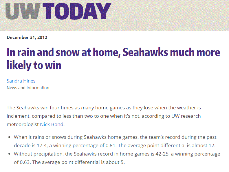
Nick Bond, State Climatologist, and co-instructor with me of the UW senior forecasting class, has examined the correlation of weather with Seahawks performance (see below).  The numbers are impressive: the Seahawks win FOUR TIMES as many home games as they lose when the weather is poor, with an average point differential of 12 during bad weather.


So if you are going to the game, bring a hat and rain jacket, with your earplugs.  The NW weather gods clearly have a favorite.


Thursday, January 15, 2015

Will Snow Return to the Pacific Northwest?

The sense of desperation is palpable among Northwest snow lovers.  The Cascade snowpack is one of the worst in years, many ski areas are closed or running a limited number of lifts.  Snow day closures at local school are daydreams for local kids.

Only local mayors are content.

The first half of the snow season is now over, but should we expect the remainder of the winter to be similar?  I can't tell you how many plaintive emails I have gotten about this topic.   So let's deal with it here.

First, how bad is it?    Let's start with the latest numbers from local ski areas and other sites from the NW Avalanche Center (below).  Only high-elevation Paradise (5500 ft) is above 50%, and not by much (54%).   Others range from abysmal (Hurricane Ridge and White Pass at less than 20%) to terrible (Timberline, Stevens, and Snoqualmie at around 40%).

 Looking at the % of water in snowpack (SWE or snow water equivalent), one notes conditions are poor (less than 50%) in western Washington, Oregon, and the CA Sierra.   Things improve over northeast Washington and eastern Oregon, and are at or better than normal over Montana, Wyoming, and Colorado.


The problem, as I have documented in this blog, has been persistent ridging along the West Coast, interrupted by WARM, wet patterns associated with atmospheric rivers (the Pineapple Express).

So what about the future?

Let me begin with the KEY PRINCIPLE:

Never assume that the second half of  the Northwest snow season will be like the first.

On many years the pattern has reversed, and a poor first half is followed by a bountiful February and March.  Seriously.  This often happens.

Our models are good enough that we don't have to speculate about the next week and the news is moderately good:  there will be some snow during the next few days,

Here is the snowfall prediction for the 72h ending 4 PM on Sunday. Several feet in the north Cascades and good snow into northeast Washington and southeast BC. Unfortunately the Oregon Cascades do poorly except at the very highest elevations.  The reason?  the air mass will be very warm on Saturday as a warm front moves through;  as a result, the Oregon Cascades will be hit by heavy rain (3-5 inches).   Bad for snow.


A little more snow continues in the WA Cascades. the next 24 h (see below), but after that the ridge builds back again and shuts the snow down.
So if you aren't going to or watching  the Seahawks game on Sunday, that would be an excellent day to hit the slopes, particularly from Snoqualmie northward.   Monday will be decent as well for those who are off that day.

Now the bad news.  The NOAA Climate Prediction Center 6-10 day, 8-14 day, 1 month, and 3 month forecasts are all the same and BAD.  Warmer than normal and drier than normal.  Here is the one-month prediction to illustrate.


However, the accuracy of these forecasts is quite uneven-keep that in mind.

What about the National Weather Service's sophisticated seasonal forecast model, the CFS?   You don't want to know.  VERY warm (surface temperatures) the next few months.  And it is going for ridging (high pressure over the west)--not shown here.
What about the large International Multi-Model Ensemble (IMME), which includes many long-range models?   Such a large ensemble should be more skillful. Quite warm for February and March. Ouch.


And there is a lot of agreement among the models, which suggests we should have confidence in this forecast.

The bottom line:  the second half of the Northwest snow season does not look good.  The ski areas will get by...barely...with a bit of snow here or there.  But the snowpack forecast is not favorable and a betting person would wager that the snow depth on April 1 will be below normal.

Ah yes...it looks like light rain during the Seahawks game...which is probably favorable to Seattle.
10 PM Thursday Night It Was Snowing Hard in Snoqualmie Pass

Tuesday, January 13, 2015

It's Raining, But the Radar is Clear. Why?

Saturday afternoon before taking a pre-game run, I took a look at the radar--no echoes over Seattle.

But hitting the trail, it was obviously raining lightly and my sweatshirt got quite wet.

Here is a photo at the time I left, around 2:15 PM, you see the drops on the tree?


Now here is the radar.  No rain over north Seattle where I live.


How could this happen?

And during the big Seahawks game it was clearly drizzling or raining lightly, but the radar showed nothing.

So is something wrong with the weather radar?   The answer is no...  The origin of this discrepancy lies in the type of precipitation and the limitations of weather radar.

On Saturday the precipitation was light rain and drizzle, and these small droplets were descending out of shallow clouds.  The vertical sounding at Quillayute suggested the low-level moist layer was only about 5000 ft thick (the layer where temperature and dew point were the same up to about 850 hPa):

This shallow layer produces small droplets and small droplets are hard to see in normal weather radar.  Also the intensity was light, again providing fewer droplets and thus less of a target.  The droplets got bigger as they descended from the cloud towards the ground.

But even more important is the height of the radar beam.  The closest radar to Seattle is the one at Camano Island, about 70 km (45 miles) away.   As a radar beam leaves the antenna, it rises above the earth surface.  Thus, the farther away from the radar, the higher the beam becomes (see figure).
The lowest radar beam from the Camano Island radar scans at .5 degrees above the horizon (dark blue color aloft).   The beam both rises and expands as it travels away from the radar.  As shown by the figure, by the time the bean gets 45 miles away (over Seattle) the lower part of the beam is at least 2000 feet above the surface, with the center of the beam between 3000 and 4000 ft above the surface.
Thus, the radar beam would miss the lower (and larger) raindrops, the ones that would have better chance of reflecting the radar beam back to the receiver.

Thus, it is not surprising that the radar missed the low-level drizzle that damped the surface.

So why does normal rain show well in weather radar?  Because the clouds and precipitation extend far higher and the drops are larger.

Popular Posts