Sunday, February 22, 2015

The Ridge Begins to Shift

This has been the winter of the ridge, an area of high pressure in the in the lower to mid atmosphere that has brought us consistently warm temperatures.   Downstream of our persistent ridge there has been a trough over the eastern U.S. that given them unending cold and snow.

But the ridge is shifting, with substantial implications for our weather in the Northwest.

Let me remind you of Ridge 101.  The plot below shows a situation with a ridge over the western U.S.  The color shades are the heights of a pressure surface (in this case 500 hPa).  Where the higher heights push northward, there is a ridge, pushed southward--a trough.   When the ridge is over us (like in this figure) we are generally dry.  During most of the year, we are also warmer than normal when the ridge is overhead (but during the middle of winter sometimes we can be engulfed by fog at low levels).  East of the ridge there is northwesterly flow, bringing cold air from the north.   If a disturbance is embedded in this NW flow, we can have precipitation--yes, even snow.  On the western side of the ridge, there is southwesterly flow:  warmer than normal temps and usually wet.  This is when we get the atmospheric rivers, with heavy precipitation.


This winter we have gone between having the ridge over us (dry, and often a bit warmer than normal) to brief situations when the ridge slipped a bit eastward, give us warm, wet conditions.   As a result, we have had an overall warm winter, with normal precipitation.   Rarely, has the ridge slipped west of us, putting us in the cooler flow.   

But that is going to change.

Let's see how things have evolved and will evolve this week by looking a series of upper level (500 hPa maps).

First, last Monday at 10 PM PST.  Big ridge over the coast, but most of the northerly flow is to the east of the region. (winds are parallel to the lines, where lines are closer together, the winds are stronger, higher heights to right of the winds).  The jet stream is associated with the large gradients in the heights, with the jet stream being the conduit for weather disturbances.

 Saturday at 4 PM.  Looks familiar?  But there has been a subtle westward shift of portions of the ridge and northerly flow is working its way into eastern Washington.   Temperatures have cooled a bit...and there was even some frost in my neighborhood this morning.

 Fast forward to the prediction for Wednesday morning.  The ridge has broadened and shifted to the west.  Disturbances (troughs) are getting around the ridge on its northern flank.

 And by Friday AM, the ridge has strengthened offshore and we are now on the cold side of the jet stream

So we are not only moving into cooler air, but are now vulnerable to feeling the effects of weather disturbances embedded in the northwesterly flow.    This is good for mountain snow lovers.

On Thursday/Friday a disturbance WILL reach our region.   Here is an upper level map for Friday at  one AM;  you can see the upper level trough over us and the big ridge offshore.


Thw 48 hr total precipitation ending 4 PM on Friday is shown below.  Modest amounts, particularly over the western side of the Cascades (1-2 inches)


And there will be snow, as shown by the 48h snowfall totals over the same period (6-8 inches in the Cascades) and even eastern Oregon gets whitened up.  Not a game changer, but helpful.


It is not unusual for a late winter weather regime change, particularly for years with dry/warm mid-winters.  It doubt we will make up for the abysmal snowpack, but we may be able to mitigate the situation at the end.

Rider Oasis Questionnaire

A group of bicycle enthusiasts are developing the idea to place convenient kiosks around the city with items of interest to cyclists.  They have a questionnaire available on their website.  Please take a look and give them feedback if you have a minute...thanks.

The Pacific Northwest Weather Workshop

Interested in attending the big local weather workshop of the region?  The Pacific Northwest Weather Workshop will be held in Seattle at the NOAA facility on February 27-28th.   Everyone is invited and the majority of talks are accessible to laypeople.  To attend you have to register or they won't let you in the gate.  There will be a major session on the Oso landslide.  There is a registration fee that covers refreshments and food, and special student pricing.  If interested, check out this website.

Friday, February 20, 2015

Whatever Happened to El Nino?

Last year, the media couldn't stop talking about a coming super El Nino.

Then just a regular El Nino.

And now they just don't talk about it anymore.

Good reason... the famed El Nino has flamed out, and its impact on NW weather is minimal at best.

El Ninos are associated with substantially warmer than normal water in the eastern tropical Pacific. Meteorologists pay particular attention to the sea surface temperatures (SST) in the Nino 3.4 area (see map below)


Here is the plot of the SST anomalies (difference from climatology--or normal).  After peaking to a modest 1C, it is dropped to about .5.


NOAA has put a lot of buoys out in the tropical Pacific that are capable of measuring water temperatures below the surface.  As shown by the following plot, cooler water has become established under the eastern Pacific. (The figures has depth on the  y-axis and longitude on the x-axis, crossing the Pacific from west to east).  Not suggestive of an El Nino.


The latest NOAA probabilistic El Nino forecast give a probability for El Nino of around 55% now and that declines over time, with a nearly equal chance of  experiencing a neutral year, when SSTs are near normal


With a no-show El Nino this year, the associated atmospheric circulation patterns have not occurred, like a weakened equatorial trade wind and heavy rains over southern CA.

Instead of an El Nino pattern, high pressure has locked on the west coast and that will certainly be the case this weekend as a huge ridge will redevelopment, configured in the classic "omega" pattern:


Wednesday, February 18, 2015

The Winter of 2070

There is a fascinating aspect of our present anomalously warm/snow-free winter.

It is very similar in many ways to what will be experienced in an average winter about a half-century in the future --more so than any recent year I can think of.


Hurricane Ridge (5200ft) on Monday Afternoon

As you all know, this winter has been much warmer than normal.  Here is the difference of the average temperature of the last 90 days from climatology (1980-2009).  Roughly 4F warmer than normal over the Northwest.

The UW Climate Impacts Group has published a report outlying their prediction of the future Northwest climate.  Here is a figure from that report showing predicted temperature change (relative to 1960-1989) with time.  They show the warming from various scenarios or RCPs (Representative Concentration Pathways).  RCP 8.5 (solid red line) is the most aggressive.   For reasons that I won't go into, many of my climate colleagues believe it it too aggressive and the RCP 4.5  (blue line) will prove closer to what will happen.  A number of climate model simulations were made, with the solid lines being the average of many runs (the range of these simulation is shown by the lighter lines).

Reading off the graph, it looks to me that a 4F warming from the end of the 20th century would occur around 2070.  If we choose the more aggressive RCP 8.5 scenario the answer would be a bit earlier (say 2050).


What about precipitation during the past 90 days?   This figure shows that the precipitation this year has been close to normal over most of the Northwest.  This is similar to what the climate models are suggesting for later in the century.

The snow pack is now running about 30-40% of normal, less in some places, more in others (see figure).  Similar to what a number of regional climate models are suggesting for around 2070.


So forget about checking out time machines or reading dry scientific reports on the future climate of our region.   You are living it right now, experiencing the conditions that will be typical 60 years in the future. 

We will have enough water 60 years from now for the urban populations, but skiing will be lousy at the lower elevations.  Snoqualmie Summit will be memory as a skiing venue.   And quite honestly, the winter temperatures will be more pleasant around here.   But the lack of snow, will bring serious consequences:   it will be bad for fish and there are serious problems for the Yakima agricultural area. This summer will be an interesting test of how our region deals with a very low snowpack that will be common late in the 21st century.    Keep in mind that winter is not over yet and the models are suggesting a major weather regime change late in the month, towards a wetter and colder pattern.


You don't need this...you are already in the future.


The Pacific Northwest Weather Workshop

Interested in attending the big local weather workshop of the region?  The Pacific Northwest Weather Workshop will be held in Seattle at the NOAA facility on February 27-28th.   Everyone is invited and the majority of talks are accessible to laypeople.  To attend you have to register or they won't let you in the gate.  There will be a major session on the Oso landslide.  There is a registration fee that covers refreshments and food, and special student pricing.  If interested, check out this website.

KPLU Climate Talk (SOLD OUT, but there is a waiting list)

If you want to hear me talk about the regional implications of global climate change in some detail, please come to my UW Kane Hall talk on March 11th.Sponsored by local public radio station KPLU, tickets for this event can be secured at this web site.

Monday, February 16, 2015

The Origin of this Winter's Weather Anomalies: Is There A Global Warming Connection?

In my previous blog, I talked about the anomalous and persistent high pressure/ridging that has dominated the western U.S., producing generally dry and warm conditions.  And the equally persistent, and directly connected, low pressure and cold influencing the eastern U.S.

In this blog, I will spend some time examining the claims that global warming is behind it.  A final blog will discuss the true origins of the western North American ridging.


 Hurricane Ridge (5200 ft) in Washington Olympics is snow free, while Boston has several feet.

As I explained in my previous blog, the proximate reason for the anomalous weather is clear:  the highly amplified upper-level wave pattern with a major ridge over the West Coast and a trough over the eastern U.S.   Thursday evening's  (10 PM PST) 500 hPa upper-level chart  (top figure) shows the story.  The colors are heights (like pressures) and solid lines are sea-level pressure.  Higher heights bulge up in the west and lower height over the eastern U.S.  The lower picture shows temperatures in the lower atmosphere (around 5000 ft) at the same time.  Warm (yellows) in the west, cold (blue/purple) in the east.


So the amplified waviness of the upper level flow (and the associated jet stream) is what is making it warm in the west.   It is not due to any kind of uniform global warming over the planet.   The East Coast is as anomalously cold as we are anomalously warm.

The next question is obviously: is this amplified upper level pattern and couplet of warm-west and cold-east the result of global warming due to anthropogenic greenhouse gases or is it mainly natural variability?  I believe the facts and peer-reviewed literature suggest the latter, but you be the judge from what I will present below.

The most influential paper suggesting a global warming origin is by Jennifer Francis and Steve Vavrus:

Francis, Jennifer A.; Vavrus, Stephen J. (2012). "Evidence linking Arctic amplification to extreme weather in mid-latitudes". Geophysical Research Letters


In this paper they claim that global warming will weaken the jet stream by warming the Arctic, reducing the temperature gradients that drive the jet stream.  They hypothesize that a  weakened jet stream undulates more, producing a more amplified wave pattern with more cold waves in the eastern U.S. in the winter.  The media has given this paper huge play and it has been heralded by major political figures, like the President's Science Adviser, John Holdren.  And many environmentalists want to believe this paper is correct.

Unfortunately, the paper is deeply flawed and most members of the research community acknowledge it.    First, the Francis/Vavrus method of determining the amplitude of the waves was incorrect.  Instead of measuring the daily values of wave amplitude, they mistakenly used seasonal excursions.  A paper by Elizabeth Barnes of Colorado State University did the calculation correctly and found no trends in wave amplitude.

Furthermore, there is no reason to believe the upper tropospheric jet will weaken under global warming since increased CO2 enhances warming of the upper tropical troposphere, increasing the north-south temperature gradient, thus strengthening the jet.  Combined with the weakened gradient at low levels, this appears to result in jets with little change.  In addition, even if Francis/Vavrus were right that the jet was weakening, theoretical research is emphatic that this would deamplify the wave pattern and not strengthen it.

You want more?   There is no sign that cold waves have been increasing in the eastern U.S. as Vavrus/Francis claim;  in fact, they are declining.  And global climate models run under large increases of CO2 do not show the amplification that Francis/Vavrus claim.

Anyway, this Francis/Vavrus hypothesis is clearly wrong, but the media and some environmentally minded folks can't seem to let go of it.

More recently, the media and others have liberally cited another paper by some folks at Stanford to back the global warming/West Coast ridge connection.


Written by Daniel Swain and others, this paper starts by making the case that the drought and west coast ridging is historically very unusual. This is entirely correct.   So unusual and such an outlier, that great care needed to be taken in suggesting this was the result of progressive global warming of the past decades.

Then they compared climate model simulations for a pre-industrial era and the late 20th century regarding the amplitude of west coast high pressure at particular locations and found that it had increased;  on this basis, they suggested that anthropogenic CO2 is increasing pressure/heights making extreme values more likely.    This is, of course, true.  If you warm the atmosphere, the heights of pressure surfaces (like 500 hPa) will rise.    But this says NOTHING about troughs and atmospheric ridges, because they are associated with gradients of heights, not absolute values.

Lost you on this?   A ridge or high pressure area is only important because heights or pressures are lower in adjacent areas.   So for a ridge to become important and influence the weather, height must rise more in the ridge than elsewhere.  They did not show that and to be fair to them, they admitted this in the paper and back-pedaled in their conclusions.


So basically, their work DOES NOT LINK GLOBAL WARMING to the drought or enhanced high pressure areas along the coast.  But that did not stop the media from saying so.  In fact, Stanford's PR office was pushing this angle.


 Finally, there is apaper by Wang. et. al in Geophysical Research Letters (2014) that is being heavily cited in the media as proof that mankind is enhancing the western U.S. ridging:


In this paper,  the authors come up with a "dipole index" that measures the amplitude of the trough/ridge pattern.  Their results showed that 2013-2014 was very unusual, but if you look at their graph you will see that there is absolutely no trend, as one would expect if progressively global warming was the cause:
From GRL, Wang et al., 2014, page 3222

 Then they discuss the anthropogenic influence of human greenhouse gas emissions on the dipole amplitude.  Strangely, they examine how the variance (variability) of the dipole changes in time not the critical pattern of ridging on the west and troughing in the east.  They find that using analyses based on observations (the 20th century reanalysis from NOAA) that there is little trend in variance since 1950 or since 1975 when satellite data started to become available.   So this would really indicate that the real atmosphere is not changing.

But then they ran single climate simulations with and without greenhouse gases and found the variance increases with CO2.  What these single simulations mean and their relevance to global warming's impact on the west coast ridging is uncertain, but this did not stop them from claiming:

"there is a traceable anthropogenic warming footprint in the enormous intensity of the anomalous ridging during winter 2013-2104."


The bottom line is that a careful reading of any of the papers claiming an anthropogenic origin of the amplified upper atmospheric waviness reveals that they all have major flaws.  Or the media has hyped them beyond recognition.   I don't know of any leading atmospheric scientist that is claiming such a relationship.  But that has not stopped the media from hyping the connection.


There are, in fact, a number of papers that provide a different view, that the origin is from natural variability.  For example, in the same issue as Swain et al, a paper by Funk et al looked at a large collection of climate model simulations and concluded that global warming had no impact on the  West Coast ridging:


And as I mentioned in my last blog, a report by leading NOAA scientists have said the same thing:  the West Coast ridge is probably the result of natural variability.  There is no absolute certainty, of course.

Global warming is a serious issue, but we must keep it in perspective in comparison to natural variability.

In my next blog on this topic I will examine the results of recent papers that show the dominance of natural variability in producing the West Coast ridging.


KPLU Climate Talk

If you want to hear me talk about the regional implications of global climate change in some detail, please come to my UW Kane Hall talk on March 11th.Sponsored by local public radio station KPLU, tickets for this event can be secured at this web site.

The Pacific Northwest Weather Workshop

Interested in attending the big local weather workshop of the region?  The Pacific Northwest Weather Workshop will be held in Seattle at the NOAA facility on February 27-28th.   Everyone is invited and the majority of talks are accessible to laypeople.  To attend you have to register or they won't let you in the gate.  There will be a major session on the Oso landslide.  There is a registration fee that covers refreshments and food, and special student pricing.  If interested, check out this website.

Friday, February 13, 2015

Revenge of the Ridges

Looking at the model forecasts tonight, I could not believe me my eyes.   Ridging or high pressure along the West Coast will dominate our weather next week and perhaps longer.

It simply doesn't go away.  It may get knocked down for a day by a weak ridge...but it just pushes back up.  The vampire of weather patterns....but there is no silver bullet or wooden stake to stop it.

If only meteorologists had similar equipment for dealing with ridges that refuse to die.

For the West Coast, the ridging will bring generally dry, warm conditions.  Spring in winter.

But over the eastern U.S., the resulting downstream trough forebodes unusual cold and snow.

So, lets look at a series of upper level (500 hPa) weather maps from the National Weather Service GFS global model. The solid lines are height lines;  where they buckle up to the north there is a ridge and where they push southward, a trough.  Wind are also shown.

Today at 4 PM PST.  Big ridge over the West Coast, trough over the eastern U.S.


Friday night (10  PM) is the only break form ridge-land, as a weak trough pushes down the ridge over the NW, resulting in a few light showers overnight. Still a warm pattern.


Sunday morning, the ridge is back in force.  Active trough in the east and a major snowstorm over the Northeast.
 Monday at 4 PM.    Ridge strengthens over the west.
 Fast forward to Thursday at 4 PM.  Ridge is still in place.
 Saturday at 4 PM.  Still a ridge.  And yes, the trough remains in the eastern U.S.
Monday after that...same thing.  This is incredible.

Other modeling systems (like the European Center and the Canadian Meteorological Center) are going for the same persistent ridging over the West.  Ensemble systems (many forecasts made at the same time) show the same thing.  Our confidence in this forecast is very high.  The implications for those of you who enjoying hiking, biking, and sun bathing are very positive.  The garden centers are stocked for the inevitable crush of  folks getting the itch to weed and hoe.  For skiers...well, lets skip that part.

The NOAA Climate Prediction Center 6-10 day forecast is consistent with the above, with extraordinary cold predicted over a huge area of the eastern U.S.  Dark blue means great confidence in below normal temperatures.

I can not stress enough that there is no reason to expect that this has anything to do with global warming.   And those in the eastern U.S. should not be claiming that it is proof of global cooling.   In fact, some of the latest research (example here) provide strong evidence that the pattern of western ridging is the result of natural variability.  It is not unprecedented.

Several of you have emailed protests to me, pushing a theory that global warming causes weakening of jet streams that then meander more.   This is a completely discredited theory.  Observations show the jet stream is NOT weakening, global climate models do NOT show more meandering jet streams as the earth warms, and the papers claiming this mechanism (e.g., Varvus and Francis 2012) have fatal flaws.  Other research has shown that sea surface temperature anomalies can produce such atmospheric ridging.   And the origin of the blob of warm water off our coast during last year--that was caused by the ridging.

Too many climate advocacy groups are weakening their credibility by pushing an anthropogenic global warming origin of this event.  

I will talk more about such mechanism in one of my next blogs.


KPLU Climate Talk

If you want to hear me talk about the regional implications of global climate change in some detail, please come to my UW Kane Hall talk on March 11th.Sponsored by local public radio station KPLU, tickets for this event can be secured at this web site.

The Pacific Northwest Weather Workshop

Interested in attending the big local weather workshop of the region?  The Pacific Northwest Weather Workshop will be held in Seattle at the NOAA facility on February 27-28th.   Everyone is invited and the majority of talks are accessible to laypeople.  To attend you have to register or they won't let you in the gate.  There will be a major session on the Oso landslide.  There is a registration fee that covers refreshments and food, and special student pricing.  If interested, check out this website.

Wednesday, February 11, 2015

What was the mysterious dust raining down in eastern Washington?

I love a good weather mystery.

On Friday, I started to get emails and calls about a strange white/gray powder that was being deposited on cars and windows over southeastern Washington and northeastern Oregon.

The picture below is the kind of material we are talking about.    Good for car wash businesses, but roughly a .001 on the meteorological Richter scale.  I put it aside.


The media started having a field day and speculations went wild, many certified by "scientists."


So the possibilities included:

1..   Volcanic dust from Russia
2.     Dust from a Nevada dust storm
3.     Ash from last summer's fires
4.     Dust from the Middle East
5.    Dust from dry lake beds in Oregon

and more.

First, where did folks observe a white/grey powder Friday morning?  Here is a summary produced by the meteorologists at the Spokane office of the National Weather Service.  Southeast Washington and northeast Oregon.


Some of the possibilities were easy to reject.  The dust from the Middle East and volcanic dust from Russian volcanoes didn't make sense, since why would the dust be so localized?   The dust storm in Nevada was promising until I looked at the wind field, which would blow material too far east to reach SE Washington.

Then there was the theory, proposed on the NWS Spokane blog, that the material was blown from the alkali dust field around Summer Lake in southeast Oregon (see red marker on map below for location).

Here is a picture of the lake I found on the web.  And you say a large dusty area on the satellite picture above.


To raise a lot of dust would require strong winds around the dry lake bed.   So I found the winds at the Summer Lake RAWS observing site and plotted them for the Thurs to Saturday period (see below, second panel).    Big winds, gusting to over 65 mph!    More than strong enough to lift loads of dust.


 I wanted to check out the origin of these winds, so I looked at the 18 hr WRF model surface wind gust forecast for 10 PM Thursday night.  If you look closely you will see strong winds (gusts to 55 knots) in the right place--winds associated with strong downslope flow off the Siskiyou/Klamath mountains.


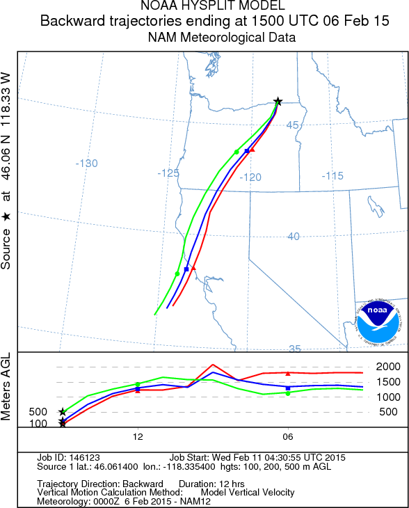
  My final evaluation is to determine the air trajectories that ended up, at say Walla Walla, in the dust zone.  To do so, I ran the NOAA Hysplit trajectory model using the 12-km NWS NAM model for the 3D wind fields.  Lo and behold the air came from EXACTLY the right region...around Summer Lake.


Why is Summer Lake a source of dust this winter and not most winters?  Could it be that this winter has been usually dry and warm?  Here is the percent of average precipitation for the last month.  The summer lake are is has received 25-50% of normal precipitation.


And here is the departure of temperature from normal. Way warm, perhaps 6-9F above normal.   Start with very low precipitation and add much warmer than normal temperatures (which encourages evaporation)--what do you get?  A much drier than normal surface.


Anyway, the NWS Spokane folks deserve credit for suggesting this solution and I basically have just provided a bit of supporting evidence.   There are, of course, some other possibilities, like aliens and chemtrails, but I suspect the Summer Lake  (and similar nearby lake) origin is the right one.

_______________________________

The Pacific Northwest Weather Workshop

Interested in attending the big local weather workshop of the region?  The Pacific Northwest Weather Workshop will be held in Seattle at the NOAA facility on February 27-28th.   Everyone is invited and the majority of talks are accessible to laypeople.  To attend you have to register or they won't let you in the gate.  There will be a major session on the Oso landslide.  There is a registration fee that covers refreshments and food, and special student pricing.  If interested, check out this website.


Climate Change and the Pacific Northwest

I will be giving a provocative talk on this subject on March 11th at 7:30 PM Kane Hall on the UW campus in Seattle.  Sponsored by local public radio station KPLU, tickets for this event can be secured at this web site.


Popular Posts