Thursday, June 18, 2015

Project Couture Magazine Casting Calls 2015 Philadelphia Model Face Off Photo Shoot


The International Beauty Movement

Fashion Magazine Model Casting Calls 2015

For The 2015 Model Face Off Summer Magazine Photo Shoot

For Project Couture Magazine, Out Next Magazine,

Ripping Runways Magazine, Girl 9 Magazine,

and Salon Savvy Magazine.


This will be one of the hottest magazine photo shoots of the year featuring some of the top international models that you have seen featured in our magazines facing off in this hot magazine photo shoot as well as models coming in from eight different states to face off in this hot 5 magazine photo shoot that will be taking place in Philadelphia within the next 30 days, and this is one modeling opportunity that you do not want to miss if you are serious about taking your modeling career to the next level, being featured in a magazine that is read by thousands of people daily, including fashion industry insiders, casting directors, and entertainment insiders.


All male and female models selected to participate in our 2015 Model Face Off Summer Magazine Photo Shoot in Philadelphia will receive a free professional photos shoot and a full feature pictorial layout in one of our Summer magazines issues, which will give you the opportunity to build an impressive magazine print portfolio that could possibly open doors to high paying fashion and entertainment jobs by being featured in one of our internationally known fashion magazines that are read by thousands of people each day, including celebrities, fashion and entertainment agents, and casting directors looking for new faces and talent.


We are seeking unique female models that are both short and tall, with a unique but beautiful look, with athletic bodies, slim curvy bodies, thick curvy bodies, sexy bodies, and physically fit bodies with height proportionate to weight, and looks great in high fashion clothing, casual clothing, sexy swimwear, and lingerie.

We are seeking Asian models, Indonesian models, Vixen models, African models, European models, Latina models, Indian models, Polynesian models, Russian Models, African American models, White models, Italian models, Mixed Race models, Swimsuit models, Creative Nude Models, Lingerie Models, Hosting Models, Multi-Talented Models, Acting Models, Singing Models, Rapping Models, Dancing Models, Ad Campaign Models, Commercial Models, Magazine Models, and models of all races.


To apply for consideration as a female or male print model for the 2015 Face Off Magazine Summer Magazine Shoot in Philadelphia, you must be ages 18-36, you will need to submit a professionally written bio with your contact information and 6 or more recent professional high resolution full body shot photos, please remember you must submit at least 6 or more of your hottest and most recent professional high resolution full body photos (that are no older than 12 months) with no writing on them, no logos, or photo signatures to qualify for this amazing print magazine photo shoot.


Please submit 6 or more recent professional high resolution photos in formal dress clothing, casual clothing, swim wear, or lingerie, if you are a female lingerie or bikini model please submit 6 or more recent professional high resolution photos in lingerie, swimwear, or hot fitness wear, remember you must submit at least 6 or more of your hottest and most recent professional high resolution photos (that are no older than 12 months) with no writing on them, no logos, or photo signatures to qualify


We do not accept photos that are older than 12 months, we do not accept camera phone photos, we do not accept photos with more than one model in it, we do not accept photos posted on other websites, we do not accept low resolution photos, we do not accept photos with writing on them, logos, or photographer signatures, and we do not accept personal photos that are taken in your home, we do not accept photos that are collages or have effects, or have borders added to them, so please do not submit none of the above or your photos will not be considered.


Submit professional photos and bio to: internationalbeautymovement@aol.com


PLEASE READ THIS CASTING CALL CAREFULLY,


DO NOT APPLY TO THIS CASTING CALL IF YOU CAN NOT PROVIDE YOUR OWN TRANSPORTATION AND LODGING TO PHILADELPHIA IF YOU ARE SELECTED FOR THIS MAGAZINE SHOOT.


YOU MUST BE ABLE TO TRAVEL TO PHILLY IF YOU ARE SELECTED, WE DON'T PAY FOR TRANSPORTATION OR LODGING; THIS WILL BE A FREE MAGAZINE PHOTO AND VIDEO SHOOT FOR THE MODELS THAT ARE SELECTED TO FACE OFF IN THIS HOT MAGAZINE PHOTO SHOOT OF THE SUMMER.


We do not provide transportation or lodging for models, so please do not apply to this casting if you are not able to travel to Philadelphia if you are selected to participate in The 2015 Model Face Off Summer Magazine Photo Shoot For Project Couture Magazine, Out Next Magazine, Ripping Runways Magazine, Girl 9 Magazine, and Salon Savvy Magazine.


Please Read Casting Call Carefully:


You must visit one of our websites below

to fill out an audition form:


International Beauty Movement:


Salon Savvy Magazine:


Ripping Runways Magazine:


Girl 9 Magazine:


Konscious Money Entertainment Group:


You can read our hot fashion magazines at:


Please check out Project Couture Magazine at the links below:


Ripping Runways Online Magazine:


Girl 9 Online Magazine:


Salon Savvy Online Magazine:


Please visit our casting call link to view all of our current casting calls for female models and stylists at: http://rippingrunways.blogspot.com/


All photos submitted by models will be evaluated on creative posing, hair and makeup, photo shoot location, and unique look.


Chambers Bay Detailed Forecast

Chambers Bay is a "Links Style" course, which means it is a coastal course with lots of natural grass and few trees.  Links-style courses tend be open to the wind...some might call them windswept...and wind can have a huge influence on the play.  Chambers Bay has a lot of terrain (see picture) and the interaction of wind off the Sound with the hillocks and valleys can produce a complex low level wind distribution as well as gusty conditions.


The weather has really been ideal the last few days (see plot of surface observations at a weather station on the water side of the course).  Temperatures getting into the low to mid 70s.   Modest winds (less than 10 mph most of the time), although the winds increased on Thursday afternoon, with a gust of 20 mph.   Wind direction has been relatively steady during the day (southwesterly. Partly sunny conditions.  And no rain except for a few sprinkles tonight.


 A weak upper trough is moving through now, with most of the action going through northern Washington and BC.  The latest infrared satellite photo clearly shows the clouds associated with the trough moving into our region  (see pic) and the latest radar image (8:10 PM) has moderate precipitation falling over NW Washington (see below).  But little will reach the ground south of Seattle.  Local meteorologist Jordan Sutton, who was at the venue at 8 PM tonight, reported a few sprinkles.   God knows we need as much rain as this system can deliver.


As the trough moves through tomorrow,  a Puget Sound convergence zone will develop over the central Sound but the south Sound will be dry (see 24h precipitation ending 5 PM Friday).   Why? The area south of Tacoma will be in the rainshadow of the Olympics (since the flow will be from the Northwest).

The cutting edge high-resolution NCAR ensemble system (based on 13 high-resolution forecasts) indicates a similar pattern for the same time period (see below)


Nice rain in the Cascades...a very good thing.   Tomorrow (Friday) will start off cloudy at Chambers Bay with a slight chance of a sprinkle or two.  But conditions will improve during the afternoon, with partly cloudy skies and temps getting to around 70.

Saturday will be warmer and dry, with highs in the mid-70s.  Upper 70s on Sunday. Comfortable weather for players and spectators.

......................................

As an aside, my favorite local golf course wind stories are about Suncadia near Cle Elum.  They should call the location Windcadia, since it often is hit by strong westerly winds moving through the Stampede Gap in the Cascades.   One time I watched folks trying to play a round when winds were gusting to 30-40 mph.  Their comments can not be repeated in this family friendly blog.

When the wind blows at Suncadia, the game gets a bit more challenging.


Tuesday, June 16, 2015

Chambers Bay Weather Secrets

With media from all over the world descending on the Chambers Bay Golf Course, it was inevitable that local meteorologists like myself would start getting calls.

The few I talked to were amazed by how perfect the weather has been this week:  clearly they were expecting rain and clouds, as befitting Northwest legend.   When I told them that the south Sound possesses a Mediterranean climate with dry summers and low humidity, they could hardly believe it
.

In fact, you could hardly pick a more ideal venue for the U.S. Open than Chambers Bay in mid-June:

1.  Very low chance of thunderstorms or heavy rain
2.  Mild temperatures that are easy on the crowds and players
3.  Climatologically dry conditions (much drier than virtually anywhere in the eastern 2/3 of the U.S)
4. Low to modest winds.

The meteorology of Chambers Bay is heavily influenced by the nearby Sound, which substantially moderates the temperatures year round.   The course also slopes down to the Sound (see picture above and map below).  As a result of these two factors, the lower holes tend to be cooler and windier, getting air coming off the nearby water.   The wind can pick up a bit during the late afternoon as the southern part of the Sound Breeze reaches the course. During the evening, as the land cools, there is a tendency for for air to drain downward towards lower elevation.


A new weather station in Chambers Bay near the water, shows some of these characteristics, on Monday, June 16th.


The weather should be ideal on Wednesday and Thursday, reaching into the mid-70s.   The big question is Friday.  An upper trough will approach our region (see the 500 hPa upper level map for 5 AM), which will make Friday a cloudy day.


As the trough approaches on Friday, showers are expected, although most of the rain should be north of Seattle. (see forecast below for three-hour rainfall ending 5 PM).   So if you are going to Chamber's Bay that day, bring your (golf) umbrella....or at least a water resistant jacket and hat.


The good news is that the weather should rebound over the weekend.

Sunday, June 14, 2015

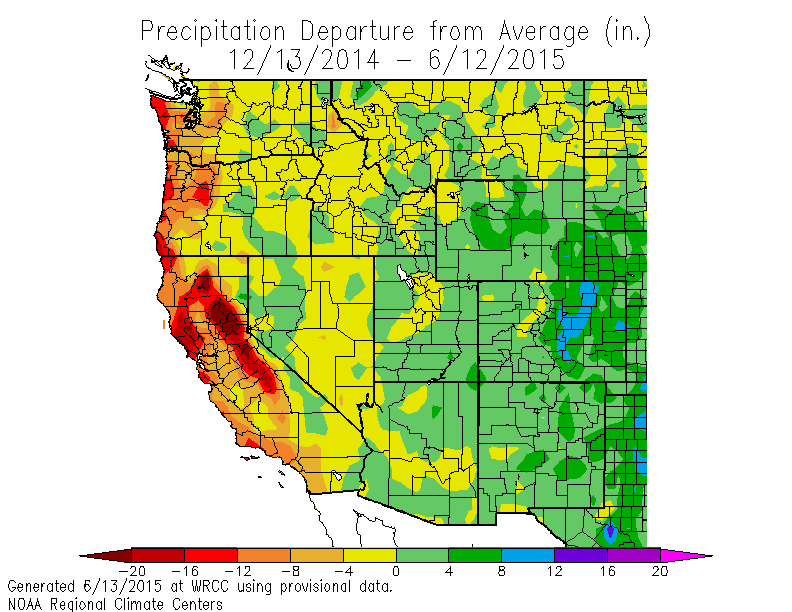
Coastal Dry, Inland Wet: The Western Seesaw Precipitation Anomaly Doesn't End

With all the talk of drought lately, a critical subtly is often missed by the media and others.

While the coastal regions, west of the Cascade and Sierra Crests have been far drier than normal, it has been moister than normal to the east.  

Let's go to the data to show what I mean.   The maps below will show you the difference from normal (the anomaly) of precipitation over the western U.S. for different periods;  these graphics are available from the Western Region Climate Center in Reno, NV.

For the past month (below), western Washington has been ground zero for dry conditions, with western Oregon being right behind.  But the situation changes radically over eastern Washington and Oregon, with many areas wetter than normal.  Head to Nevada, southern Idaho, and Utah:   it is downright moist. And east of the Rockies it is crazy wet.

But that is only  for the last 30 days you argue!  Fine.  How about the past 90 days?  (see below).  Very similar pattern with eastern WA with above normal precipitation.
Still not convinced that something is going on?  Let's check out the last 6 months...basically, the same, except that the California dryness is more severe.

One year?  Same thing.

So to properly understand our current water situationm the potential for wildfires this summer, and regional agricultural impacts, one must appreciate that the Cascade crest has separated two different regimes:  far dryer than normal over western Washington and Oregon, and wetter than normal to the east.  

Thus, it is important that folks in Seattle or Portland, mourning their desiccated gardens and browning grass, don't assume that the same is happened to the east.    And it is doubly important that our media and politicians don't make that assumption as well.

You can tell that mother nature knows the correct story in several ways.  Take wildfires.  We have been told by several media sources that wildfires would hit hard and early this year.  Some even said we were in a TINDERBOMB situation.  Well, we are well into June-- what has the wildfire season been like this year? Much worst than normal?

Well, let's look at the official U.S. government numbers from the National Interagency Fire Center (see below), which show the number of fires and the number of acres burned from January 1 until now (6/12/15 shown) for the entire country. The western U.S. dominates these statistics. This year 502, 254 acres have burned, the third lowest during the past 11 years, and 1/3 of the average for the previous ten years.  Only one fire is burning in the Northwest (a small fire of 103 acres that is not being extinguished--Thunder Creek in North Cascades National Park).  So much for a big, early start to the wildfire season.  It ain't happening.


We have had a huge amount of lightning and few fires during the last month.  Why?  Because the ground was too moist. And the moist conditions over eastern Washington have been very helpful to agriculture, reducing the need for irrigation from the rivers hit by the snowpack drought in the Cascades.

The question I am sure you are wondering about is: what about the future?   Will the west dry/east moist pattern continue?   We can turn to the NOAA/NWS Climate Forecast System model and check out the prediction for the next three months (see below, green and blue are wetter than normal, orange and red are drier).    The pattern is predicted to continue this summer.
Will there be new fires east of the Cascade crest?  There is little doubt the answer is yes.  There always are and warmer than normal conditions are predicted.  That will help dry things out, even if precipitation is normal.  And much of the precipitation east of the crest will be from thunderstorms, which often initiate wildfires.

The bottom line is that understanding the recent precipitation seesaw is very important, with large impacts on agriculture, wildfires, and other other major societal concerns.


Friday, June 12, 2015

Strong Winds Push Into the Strait of Juan de Fuca Thursday Evening

An interesting facet of our local weather is the occurrence of powerful winds in the Strait of Juan de Fuca during the warm season.  Such events are particularly strong when we transition out of a warm period.

Last night, a surge of cool marine pushed eastward in the Strait of Juan de Fuca, bringing winds gusting above 50 mph in the central and eastern Strait.

Here is a map of the max winds during the event.  51 mph at Smith Island (actually got to 55 mph there), 56 mph at Race Rocks (SW of Victoria), and 60 mph on Camano Is.  42 mph at Port Townsend.  Impressive.


Here is the plot of the maximum gusts at Smith Island this week....wind picked up a bit on Wednesday but the big spike was Thursday night (to 48 knots or 55 mph)


Our numerical models were predicting this westerly wind surge.  Here is the 12-h forecast of sustained winds (not gusts) from the UW WRF model valid at 5 PM Thursday.  The light green colors are sustained winds of 35 knots (40 mph)...a pretty good forecast.


The surge of marine air will bring a temporary respite from the above-normal temperatures, certainly today (Friday) and tomorrow (Saturday).  But we will be back into the mid-70s on Sunday and even around 80F on Monday.   And then a transition to cooler air on Tuesday...and yes...perhaps some winds in the Strait.

The weather story of Northwest summers is the battle between cool air offshore and warm air east of the Cascades.  Gaps in the mountains are the battle zones in this conflict and strong winds can result, when cold air makes the inevitable push eastward after a period of above-normal temperatures.


Thursday, June 11, 2015

The Blob Strengthens

It is a story worthy of a 50's science fiction movie.   A strange phenomenon brings danger and fear to society.  Without warning, it disappears.  But then, unexpectedly it returns to an anxiety ridden population.

But this time it is not science fiction.  It is not a story.  It is real.  The BLOB has returned.  Naming it is easy:  THE SON OF BLOB.

The original BLOB, named by Washington State Climatologist Nick Bond, formed the previous winter (2013-2014).   The BLOB was defined as a persistent region of anomalously warm water in the northeast Pacific.  With the air reaching the Northwest generally passing over the BLOB, the result was warmer than normal temperatures.

A good way to follow the development of this fiendish climate anomaly is to view maps of sea surface temperature  (SST) anomalies (differences between the actual temperatures and normal conditions).   Below and to the left, you see SST anomalies averaged over a week, one year ago.   The blood red color of the BLOB is apparent over the NE Pacific.   But by the beginning of November, the BLOB had weakened, while warm water developed along the coast.  Such a pattern is reminiscent of El Nino conditions...and in fact, El Nino was strengthening.

By February, the warm water was strengthening and extending westward. Enough to bring fear and concern (left panel below).  And by the first week of this month, the BLOB seems to have returned, and with it, its evil twin, El Nino, indicated by the warm waters in the eastern tropical Pacific.  Now we have a problem.  Note that the temperatures in the BLOB are 2-3 C (roughly 4-5F) above normal.


 The effects of the BLOB have become more than a little evident to everyone living in our region.  Temperatures are way above normal because of the warming effects of the ocean...it is hard for our minimum temperatures to fall much below the ocean temperatures this time of the year.  Want to see evidence of this?   Here are the surface air temperatures at Seattle Tacoma Airport for the last 4 weeks, with the average highs and lows shown.   We have been warmer than normal, with minimum temperatures consistently 3-4F above normal.  An accident?  Or the BLOB?

Our seasonal weather models know all about the warm sea surface temperatures associated with the BLOB.  What do you think they are predicting for this summer?  Let me show you the latest seasonal forecast from the NOAA Climate Forecast System forecast.    Warmer than normal along the West Coast by 1-2C (2-4F).
The BLOB itself is not an independent player.  It has been forced by an anomalous atmospheric circulation, including anomalous high pressure (ridging) centered north of our region (see map showing the height (pressure) anomalies (difference from normal) at 500 hPa (about 18,000ft) for the last 30 days.  Yellow indicates higher heights than normal.


So get out your shorts, secure an extra fan, the BLOB is back and its not going anywhere soon.


 PS:  There WAS a movie Son of Blob and you will never guess who directed it (to his eternal embarrassment).  Larry Hagman of Dallas and I Dream of Genie Fame.


Tuesday, June 9, 2015

Crazy Rain Offshore

Looking at a recent radar image from the Langley Hill weather radar near Hoquiam, you would be running for an umbrella and your rain gear.  Here is the image around 8:51 PM Monday.   Wow.  This is the radar reflectivity (the amount of radar signal scattered back to the radar) from the lowest radar beam (.5 degrees above the horizon).   VERY heavy precipitation is indicated offshore.   Such dark reds are either torrential rain or hail.    But none of the forecasts are calling for rain.  What gives?


Next, lets check the visible satellite image a few hours earlier (6:30 PM).  NOTHING IS OUT THERE!

Our computer model forecasts indicate no chance of precipitation over the eastern Pacific.

So that is going on?    A profound case of anomalous propagation produced by a low-level inversion.

Radar beams emitted by weather radars normally don't go straight:  they are bent slightly (refracted) downward by the change of atmospheric density with height (air is denser near the surface and less dense aloft).  Such refraction is good, because it gives our radar extra range, partially compensating for the curvature of the earth (see figure).


An inversion, when warm (less dense) air is above cooler (more dense) air, can really rev up the refraction by causing a greater decrease in density with height.    And with very warm air aloft and cool air near the Pacific Ocean surface, the last day or two has had strong inversions.

To show this, here is the vertical temperature sounding at Quillayate, on the WA coast on Monday morning.  The dew point temperature is also shown (left line).    The Y-axis is height (700 hPa is about 10,000 ft) Very strong inversion above a layer of cool air near the surface.


So down worry too much about rain along the Washington Coast for the next few days.

There were some isolated thunderstorms over eastern Oregon yesterday (see radar image for 7:45 PM Monday).  A few isolated lightning strokes.


But big changes are a'coming this weekend....with far cooler temperatures and light showers on tap.  Enjoy the warmth...it won't last.