Wednesday, October 19, 2016

2017 DC Model Face Off Model Casting Calls Model Search DC/MD/VA


2017 DC Model Face Off Model Casting Calls Model Search 2017 DC/MD/VA


2017 Model Casting Calls for All Aspiring Models in Washington DC, Maryland, and Virginia


The 2017 D.C. Model Face Off is a free magazine model photo and video shoot sponsored by the International Beauty Movement that now sponsors both the Los Angeles Model Face Off and the Philly Model Face Off.

The International Beauty Movement publishes Ripping Runways Magazine, Project Couture Magazine, Ethnic Queen Magazine, Salon Savvy Magazine, and Girl 9 Bikini Magazine.

The 2017 D.C. Model Face Off will be taking place in Washington, D.C. in the Spring of 2017 and all female models that are selected for this excellent modeling portfolio building opportunity will be featured in one of our popular online magazines.


We are now casting the hottest and most talented Asian models, Indonesian models, Ethnic models, African models, European models, Latina models, Indian models, Polynesian models, Russian models, African American models, White models, Italian models, Bi-racial models, erotic models, exotic models, vixen models, artistic nude models, fitness models, bikini models, inked models, nude models, and beautiful females with fit sexy bodies in D.C., Maryland, and Virginia and giving all selected female models a free magazine photo shoot and the opportunity to face off against other hot models from the DMV, all female models selected to participate in the 2017 D.C. Model Face Off in the Spring will also be featured in one of our very popular internationally known magazines.


If you are a beautiful female model that lives in Washington, D.C., Maryland, or Virginia ages 18-35 and you feel you have what it takes to be a featured print model in one of our internationally known online magazines, and you are interested in building a reputable print model portfolio, please submit 6 high resolution full body photos that are no older than 12 months and a bio with your name, age, height, weight, measurements, phone number and what city and state you are from to: internationalbeautymovement@aol.com


2017 D.C. Face Off Casting Call For Hair Stylists, Body Painters, and Makeup Artists in Washington, D.C., Maryland, and Virginia:


Are you a professional makeup artist, professional hair stylist, or body painter that would like the opportunity to compete in the 2017 D.C. Face Off for hair stylists and makeup artists in Washington, D.C., Maryland, or Virginia area?

This is your big opportunity to build an excellent magazine print photo portfolio, receive a free magazine photo shoot, and be featured in the internationally known Salon Savvy Magazine for makeup artists and hair stylists worldwide that’s read by thousands of people each day, including casting agents for both fashion and entertainment companies worldwide?

To apply for consideration for the 2017 D.C. Model Face Off as a hair stylist, body painter, or makeup artist, you will need to submit a professionally written bio with your contact information and 6-12 recent high resolution photos of your work (that are no older than 12 months) with no writing on them, no logos, or photo signatures to qualify for this amazing magazine competition.


Submit photos and bio with contact information to: internationalbeautymovement@aol.com

**A photo or video portfolio is required as part of this application process for all makeup artists, hair stylists, and body painters applying to this casting call. A URL link listed on your resume for an online portfolio is preferred, Please email us your bio with full contact information and portfolio or link of your work to: internationalbeautymovement@aol.com**


2017 D.C. Face Off Casting Call For Photographer and Videographer Internships For Talented Photographers and Videographers Washington, D.C., Maryland, and Virginia:


Fashion Photography and Videography Internships 2017 available in
Washington, D.C., Maryland, and Virginia For The 2017 D.C. Model Face Off
Spring Magazine Female Model Photo Shoot and Video Shoot
For Project Couture Magazine, Ethnic Queen Magazine,
Ripping Runways Magazine, Girl 9 Magazine, and Salon Savvy Magazine.

The International Beauty Movement internationally known online as one of the hottest and most popular modeling and fashion magazine publishers, known for its international female model searches, female magazine model photo and video shoots, TV modeling competitions, TV talent searches, and fashion events for female models and female talent is now offering Photography and Videography Internship opportunities to experienced photographers and videographers that are creative, innovative at creating bold new photos and videos, interested in building or expanding their photo or video portfolio and having their work promoted internationally in both our online magazines and on our websites, while working with some of the hottest up and coming professional and aspiring female models and talent for the 2017 D.C. Model Face Off Magazine Photo Shoot For Project Couture Magazine, Ethnic Queen Magazine, Ripping Runways Magazine, Girl 9 Magazine, and Salon Savvy Magazine, taking place in Washington, D.C. in the Spring of 2017.


This is an exciting opportunity for photographers and videographers to enhance both their creative talents, gain international recognition for having your creative work published in one of our well known magazines, expand your portfolio, as well as having your creative work seen by people in the fashion and entertainment industry that could really enhance your career opportunities.


To Apply Please See instructions below:
**A photo or video portfolio is required as part of this application process. A URL link listed on your resume for an online portfolio is preferred; also let us know what type of photo/video equipment you own.
Please email us your bio with full contact information and portfolio or link of your work to: internationalbeautymovement@aol.com   **

Please email us your bio, the type of equipment you own, with full contact information and portfolio or link of your work to: internationalbeautymovement@aol.com


2017 D.C. Model Face Off Magazine Photo and Video Shoot Event Volunteers and Interns That Live in Washington, D.C., Maryland, and Virginia


Would you like to volunteer for the 2017 D.C. Model Face Off that would give the opportunity to build experience in the Fashion and Entertainment Industry, participate in internationally known magazines photo shoot and video shoot, and have an opportunity to meet beautiful fashion models, national pageant winners, and lingerie models?


We are now accepting Event Volunteers and Interns applications from people that that would like to participate in the 2017 D.C. Model Face Off Magazine Video and Photo shoot competition in the Spring of 2017.

Must be reliable, energetic, enthusiastic, self motivated, creative and work well with people and be a team player.

Please email us 3 photos, with full contact information and why you want to be an event volunteer for the 2017 D.C. Model Face Off send to: internationalbeautymovement@aol.com


This is one of the biggest fashion photo and video shoot opportunities of the year in the DMV for all of you that would like to participate in the 2017 D.C. Model Face Off, taking place in the Spring of 2017 in Washington, D.C. this is one fashion event  opportunity you don’t want to miss if you enjoy fashion, clothing design, public relations, photography, being around beautiful models, and live entertainment.

NOTE:  YOU MUST PROVIDE YOUR OWN TRANSPORTATION TO WASHINGTON, D.C. IF YOU ARE SELECTED FOR THIS FREE 1 DAY 2017 D.C. MODEL FACE OFF MAGAZINE PHOTO AND VIDEO SHOOT.


Please Feel Free To Visit Our Websites
and Read Our Magazines At The Links Below:


International Beauty Movement Web Site:
Click the Link Below To Sponsor or Make a Donation: https://myevent.com/internationalbeautymovement

Click Link Below To Become A Member of the International Beauty Movement:


PLEASE CLICK LINKS BELOW TO VIEW Girl 9 MAGAZINES ONLINE:

Please Click One Of the Links Below To Read Ethnic Queen Magazine: http://internationalbeaut.wix.com/internationalbeauty#!online-magazine
2016 PHILLY MODEL FACE OFF VIDEO HIGHLIGHTS CLICK LINK BELOW:

https://www.youtube.com/watch?v=oBB1bMbJp6Q&feature=youtu.be


2016 Project Couture Magazine Fall DC Fashion Week Edition Link:


2016 D.C. Fashion Week Fall Show Highlights:
https://www.youtube.com/watch?v=kPQDQmA-MFw

2016 Ripping Runways Magazine Philly Model Face Edition Click Link Below:


Please visit our casting call link to view all of our current casting calls for aspiring female models, fashion events, clothing designers, photography and video internships, makeup artists, and hair stylists worldwide at: http://rippingrunways.blogspot.com/


Tuesday, October 18, 2016

A Deeper Look at Saturday's Storm: Can We Do Better?

There have been a lot of complaints about the storm forecast for Saturday, noting that the actual winds (gusting to 30-40 mph, with a few gusts to 50 mph over Seattle) were less than predicted (gusts to 40-60 mph).  If the winds were 10 mph stronger, I probably would not be writing this blog, since probably a few hundred thousand people would have lost power.

As I will describe below, there were two problems with last week's forecasts:
  • although the storm intensity was well forecast, the track was off by about 60 miles.
  • meteorologists such as myself did not effectively communicate the changing threat of this storm and the uncertainty in the forecasts.

Saturday waves on Puget Sound
Picture courtesy:  Seattle Times

The Initial Warnings

The first hint of a major storm event was apparent about a week before Saturday, when a number of the global models began predicting that Typhoon Songda would travel across the Pacific, transition to an extratropical storm, and then strengthen rapidly as it approached the Pacific Northwest.

What was particularly threatening was that model run after model run (for forecasts initialized Tuesday and Wednesday) showed a huge, deep storm developing just offshore....a storm as deep as the famed Columbus Day Storm. Here is a sample.   955 hPa. Amazing.  And of great concern.

84h forecast valid at 5 PM Saturday

We knew there was considerable uncertainty in these forecasts, since the storm had to undergo transition from a typhoon to a midlatitude system (switching energy source in the process) and would travel thousands of miles before reaching our shores.  These projections were not only consistent in time, but since they were relatively short projections (120-84 hr) there should have been some skill.  In other words, we  could not ignore the threat inherent in this forecast and had to tell the public about the possibility.

Not surprisingly, the media went bonkers after they heard about it,  with all kinds of stories about the Columbus Day Storm (see Seattle Times headline below)


Accompanying these stories were lots of scary pictures.

Let me stress, at this point (Tuesday or Wednesday) there was substantial uncertainty inherent in this this forecast, as confirmed by our ensemble systems (models run many times) and I don't think we communicated this strongly enough.

Thursday:  A New Reality

But everything changed on Thursday after the storm had gone through transition into a midlatitude system and was firmly embedded in the midlatitude flow:  virtually all the modeling system indicated a very different evolution.  There would be two storms,  another midlatitude system late Thursday and Friday morning and the Saturday storm would be MUCH weaker (965-970 hPa) and very compact.  Such a low pressure still indicated a powerful storm, in the class of the kinds of storms we get every 10 years (e.g., 2006 Chanukah Eve, 1993 Inauguration Day, etc.).   Let me illustrate.

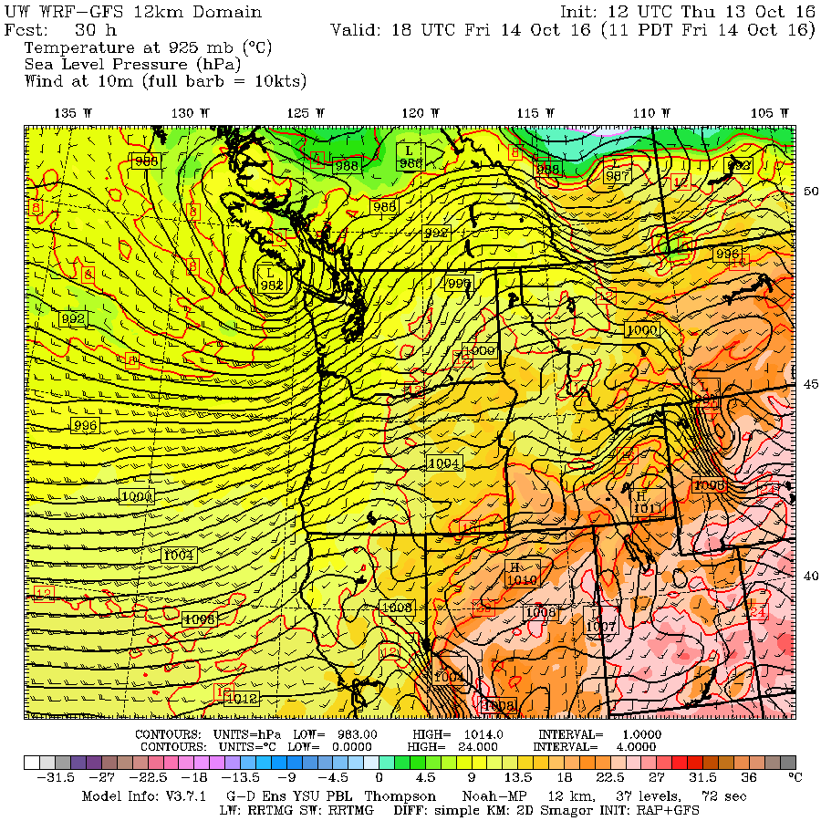
Here is the UW model sea level pressure forecast (driven by the National Weather Service GFS model) for for first storm (valid 11 AM Friday).  982 hPa low crossing the tip of the Olympic Peninsula.  Typical looking winter storm around here.  Yawn.

 And here is the forecast initialized at 5 AM Thursday for Saturday at 5 PM, showing the second (ex-typhoon) storm.  A lot different--much deeper 969 hPa with far larger pressure differences and thus wind.


The forecast started a day later (5 AM Friday) and valid at the exact same time (5 PM). A bit weaker, faster up the coast, and very compact.  Same track (across the NW tip of the Olympics).


Size Matters

Want to see the vast difference in horizontal scale between the Friday and Saturday storms?   Here is a direct comparison.  As shown by the scale of the clouds spiraling into the storm, the low center was enormously bigger on Friday.  Even Trump would be impressed.


The Problem

So on Friday, we knew we had a weaker and smaller storm, but the central pressure was still quite low (anything under roughly 985 hPa can produce strong winds around here).   But there was something else, there was reasonable uncertainty regarding the track...and that was critical for such a small storm.  There was variations of 50-100 miles among the major modeling systems and among the ensembles of specific models, like the GFS.

One way to show this uncertainty is from a graphic that presents the variation of the pressure forecasts for the UW high-resolution ensemble system,  in which the UW WRF model is run many times with different initial conditions from varying Global modeling systems.  Here is the variability of the sea level pressure forecasts for 8 PM Saturday, when the storm was making landfall.  The yellow/orange colors show substantial differences among the forecasts, signifying uncertainty in the location/intensity of the low center.


The public needed to understand that the threat level of the Saturday storm was much less than earlier in the week.  They needed to understand that this was a very compact system, and that if the actual track was only 50 or so miles west of the predicted track of the high-resolution prediction, Seattle and the interior would experience much lesser winds.

I tried to communicate this track uncertainty in my blog and the National Weather Service did as well.  In fact, forecasters at the Seattle NWS forecast office did a masterful job on Thursday morning, a portion of which I will repeat:

The exact track of the low will make a huge difference in how badly this storm impacts western Washington. There is a 1 in 3 chance of the low center directly crossing some part of the central or north coast of western Washington. This would be a worst case scenario leading to a historical windstorm for nearly all of western Washington that would be long remembered. There is a 2 in 3 chance that the low center will pass further offshore... making landfall on Vancouver Island. This outcome would confine the most damaging winds to the coast and to the north interior (areas north of everett). Inland locations such as the Puget Sound region and the I-5 corridor of southwest Washington would experience the type of windstorm that would normally be expected a couple times each storm season. Power outages and tree damage over inland locations would be less widespread in the scenario.

We not only need to provide society of the worst case scenario, but also the most probable and the uncertainties. Unfortunately, we (meteorologists) were not as effective as possible in communicating our current knowledge of the storm and the uncertainties.    How do we know that?   Because some of the media was still hawking a Columbus Day Storm type event, and exaggeration and hype were spreading through social media (see a tweet below that was making the rounds).   Folks were stripping stores bare and organizations were canceling activities even during times when no threat existed (e.g., Friday night/Sat morning).


Reality

In the end the actual storm track was about 60 miles west of the predicted location of most (but not all) of the  forecat models (see graphic).  Such an error is not large for a 24-h lead time.   


Unlike the story presented by some, the storm was not weaker than forecast (in terms of central pressure), but a bit smaller in size.  In fact, when the system passed Tatoosh Island(TTIw1) on the NW tip of the Olympic Peninsula, the pressure fell to 968.5 hPa (see graphic).   Excellent intensity forecast.


There was some false information being spread about the storm, even by local meteorologists.  For example, it was claimed that the storm was weakened by splitting into two storms.  This interpretation was based on faulty understanding of satellite scatterometer data.

Better Technology Would Have Helped

There are two main technological enhancements that would have really helped.
First, we acutely need a radar on the Oregon Coast.  The Langley Hill radar near Hoquiam picked up the storm when it was nearing landfall (see graphic at 5:10 PM Saturday), but that only gave us a few hours warning.


If we had a radar on the Oregon coast, it could have told us on Saturday morning that the storm was tracking farther to the west and greatly improved our short-term forecast.  I am not sure if Senator Maria Cantwell can help us with the Oregon radar (as she did with the Washington one)--we need our friends in Oregon to step up to the plate on this one.

Second, our ability to forecast such events is undermined by the lack of a high-resolution (e.g., 4-km grid spacing) ensemble forecast system over the U.S.   Such a system would help provide high quality probabilistic predictions of such events by making large numbers (e.g., 20-50) of forecasts.  Report after report, committee after committee, user group after user group have pleaded with the National Weather Service to do this and they have dragged their heals.   Even the National Center for Atmospheric Research (NCAR) is experimenting with a small high-resolution ensemble system (see below).  Congress needs to push NWS management to finally build this acutely needed technology and to provide funding for the additional computer resources it requires.

Communication

Finally, my profession needs to work hard to find better approaches for communicating uncertainty in our forecasts.  Methods that will be effective in this age of social media.   On Thursday, some of us will meet at the NWS Seattle Forecast Office to talk about this important topic.  We must  find a way to tell folks about the worst case, the probable scenario, the uncertainties of the forecast, and eventually provide calibrated probabilities of parameters such as wind speed.

______________________________

Please support  I-732, the revenue-neutral carbon tax swap, which will help reduce Washington State's greenhouse gas emissions, make our  tax system less regressive, and potentially serve as a potent bipartisan model for the rest of the nation.  More information here.   Some opponents of I-732 are spreading false information, suggesting that I-732 is not revenue neutral.   This claim can be easily disproven as discussed here.  I strongly support I-732 as do many UW climate scientists.  We have an unprecedented opportunity to lead the nation in reducing carbon emissions and to establish a model that could spread around the country.

Sunday, October 16, 2016

A Short Comment About the Storm

Here are the maximum winds during the last 24 hrs, which gives you a feeling for what occurred.  Gusts to 60s and even 70s mph on the coast, 30s to 40s over the interior, with few locations getting into the 50s.


One of the most interesting aspects of the event was the intense line of thunderstorms/convection that moved through around 6:30 PM (see radar image below)


As I will describe in a future blog, this was not a failure so much of the models, but of communication of uncertainty.    My profession has to stop providing the worst case or most probable weather evolution, but provide society with full probabilistic guidance.  Yesterday was a good example of the failure mode when we do not.   The media, such as the Seattle Times and several TV stations, were happy to hype up the storm because of all the interest in such events.   Many events were unnecessarily cancelled or postponed, some on Friday or Saturday morning when there was no chance of strong winds.

The key facts are this:

1.   By two to three days ago is was clear that there was no chance of a Columbus Day storm event. Prior to that, some model forecasts suggest it.
2.    It was clear that a small-sized, but intense low center was going to pass through our region.
3.    A small track error (say 50-100 km over a day) would radically change the forecast at any particular location.
4.    Such a small error was well within forecast uncertainty as revealed by our ensemble (many forecast) systems.
5.   Local meteorologists warned of the worst case situation, but failed to communicate the uncertainty of the prediction.   I tried to talk about track errors, but it is clear that I needed to do much more.

More later.


Saturday, October 15, 2016

The Storm Reveals Itself

The low center is now within range of the coastal radar and is crossing some of the coastal buoys, so we know a great deal more than a few hours ago.  Here is the visible satellite image at 3:15 PM.   You can see the clouds swirling around the nearly clear "eye" of the storm located southeast of the NW tip of the Olympic Peninsula.


The 4 PM radar shows the swirl of some precipitation bands around the low center.

The latest observations suggest the storm is considerably weaker than forecast, with a low center of 970-972 hPa.  It is also moving faster than predicted, by 1-2 hours, and 50-75 km farther offshore.

These changes will lessen the impacts everywhere, but particularly over Seattle a and southward.   Winds will increase and get gusty, with some scattered power outages.  But this is not going to be a Chanukah Eve or Inauguration Day Storm in the central Puget Sound area.

Stronger winds (gusts to 40-45 mph) have now hit the Olympia region and will spread northward and winds have gusted to 70-80 mph at Destruction Is, off our north/central coast, and 50-60 mph at several coastal locations. 

Max gusts last 24 hours.

Expect the strongest winds in Seattle between 7 and 9 PM, with weakening after that.

Today's Major Storm: A Difficult Forecast

Storm day is here for the Northwest.  A strong midlatitude cyclone is now rapidly developing off the Oregon coast, but the forecast is not an easy one:

  • This storm is relatively small, unlike the huge storm suggested by the models earlier this week.    Thus, a small error in the track, say 25 miles,  can produce a very different wind forecast for locations on the periphery of the storm (like Seattle).  
  • The storm is rapidly intensifying right now, which produces uncertainty on exactly the strength at landfall.

The satellite imagery shows impressive development.  Here is the 8:30AM infrared image.  Nice comma structure and a clearly a single low center with strong sinking behind (denoted by the black notch or slot behind it).


A very wet rain shield leads the low center, as indicated by this morning's radar imagery at the same time.

The storm center nearly went over the NOAA/NWS weather buoy 46002, nearly due west of Coos Bay on the southern Oregon Coast.  The pressure dropped to roughly 983.5 hPa and it is clear that the low passed around 1200 UTC (GMT).  We will use that in a second.  The wind sensor was unfortunately broken on the buoy.


We now have the latest model forecasts.  At the start of the forecast (5 AM, 12 GMT/UTC), it shows a 985 hPa low near 130W off southern Oregon.  From the buoy observations we know that the model is not quite deep enough by a few hPa.


 By 11 AM PDT (18 UTC), the storm has intensified to 972 hPa (13 hPa in 6 hr, which is very rapid), with a huge pressure gradient on the south side.   Very windy along the Oregon coast at that time.


By 2 PM PDT (2100 UTC), the storm deeps to 969 hPa is is right off the Columbia.  Intense winds over the northern Oregon and southern WA coasts.

At 5 PM, the low (967 hPa) is near landfall on the northern WA coast, with very large pressure differences (and powerful winds) along the south/central WA coast.  At this point winds should be accelerating over the Puget Sound interior.

Finally, at 8 PM, the low is over southern Vancouver Island, with a large pressure gradient (and winds) from Seattle northward.  After 9 PM, the low will move out and winds will subside.

I will show you the predicted winds in a second, but the key point is that the large pressure gradients will be over the coast and NW Washington and thus the winds will be more modest south of Seattle over the interior.

And now what you really want to see: the predicted wind gusts.
At 11 AM, some gusts of 50-70 knots along the Oregon coast.

 By 2  PM, the strong winds cover the coastal zone from northern Oregon to central WA.

But now lets zoom in over WA.  At 5 PM (000 UTC), with the low just offshore, crazy winds along the central WA coast (gusts over 70 knots)


8 PM?   Very high winds (60-70 knots) over NW Washington, over the western Strait, and the northern WA coast.  Seattle winds will max out around then to roughly 50 knots (57 mph).   Sustained winds will be much less (perhaps around 30 mph).  Less over Tacoma and Olympia.

 By 11 PM, winds are far less over the entire region.  We are done.

There will be some major wave action with the storm along the coast and localized coastal flooding.   The NOAA/NWS WaveWatch III forecast shows 8-9 meter (about 28 ft) waves on top of an elevated sea surface due to low pressure.


So what the key take aways?  This is going to be bad along the coast and I expect lots of power outages there.  Same for NW Washington, with the San Juans, northern Whidbey, and the Bellingham area to have gusts to 60-70 mph and plenty of power outages.    Much less over the south Sound.

1015 AM Visible Satellite Image of the Storm

Seattle is the difficult forecast...it is at the edge of the stronger winds and a small error in the storm track will make a huge difference.  At this point, gusts to 40-50 mph seem reasonable, roughly 10 mph more than yesterday, with greater winds over the northern side of the side and near the water (where gusts to 50-60 mph could well be observed).  With trees leaves and being early season, power outages over Seattle are expected.

And the most difficult question:  what do we call this storm?  The October Ides Storm?  Sukkot Eve Storm.  Songda Storm.  Someone wanted to call it the Chicken Cacciatore Day Storm (October 15 is Chicken Cacciatore Day).  No.....

_____________________________

Please support  I-732, the revenue-neutral carbon tax swap, which will help reduce Washington State's greenhouse gas emissions, make our  tax system less regressive, and potentially serve as a potent bipartisan model for the rest of the nation.  More information here.   Some opponents of I-732 are spreading false information, suggesting that I-732 is not revenue neutral.   This claim can be easily disproven as discussed here.  I strongly support I-732 as do many UW climate scientists.

__________________________________


New Weather Smartphone App, uWx

At the UW, we have developed a wonderful FREE weather app for Android smartphones that also collects pressure for use in weather forecasting. If you want to try it, please go to the Google PlayStore and download it.


Friday, October 14, 2016

Major Windstorm, Tornadoes, and Much More

Ahead of us we have a major windstorm, a minor windstorm, and heavy precipitation.  And this morning we had a tornado for good measure.

A double low center is moving through today, with a weaker low last night and its stronger sibling during the next few hours.  In fact, the infrared satellite image around 10 AM showed the second low center quite well--you see the swirl east of the Strait of Juan de Fuca?  That's it.


East and southeast of low there was cold, unstable air producing strong convection and thunderstorms.


Some of these thunderstorm were very intense and produced rotation, with at less one tornado that hit Manzanita on the northern Oregon coast (see funnel cloud and damage picture below).


The winds last night and this morning (see below for the max gusts for the 24h ending noon Friday), gusted to 30-40 mph over Seattle, but much stronger of the the coast, where 40-70 mph gusts have been noted.  Some power outages have occurred, showing our vulnerability with leafed trees and untested branches.


Winds are about to pick up around Puget Sound, as the the low center shown above moves north of Puget Sound.   Perhaps 30-40 mph gusts over land, 35-50 mph over and near water.   A few more power outages.

But the big storm will be tomorrow, late afternoon and evening.  The noon infrared satellite picture shows the feature (inside the white oval).


I have looked at the latest forecast model output and they are all on pretty much the same page, which increases forecast confidence substantially.  The bottom line is that we have a  dangerous storm, comparable to the 2006 Chanukah Eve storm or the 1993 Inauguration Day Storm, one that is following nearly a perfect track to produce strong winds over the Puget Sound region.   And the coast is guaranteed to be hit hard.

Let me show you the UW WRF version of this event, with an important note.   This is going to be a relatively small storm.  If the track of storm is shifted only a small amount (50-100 miles) from the forecast track, the winds in Seattle or other locations could be changed substantially.  Thus, there is some uncertainty in the forecast.

At 5 AM Saturday, the low is off southern Oregon
 By 2 PM, it has revved up and found right off the Columbia bars.

 At 8 PM Saturday the low is moving over southern Vancouver Island.
Game time.  This is when the winds would be strongest.
Now lets look at the max winds (gusts) from the UW's ultra-high resolution model domain (1.3 km grid spacing) during the primo wind time.

At 5 PM Saturday, gusts over 70 mph along the southern WA coast, south of the low center.  No big winds over Seattle yet.
 By 7 PM, the low is centered near Port Angeles, with 50-60 mph gusts over the Puget Sound region and much stronger winds of NW Washington and the coast.

 By 9 PM, strong winds still over NW Washington and calming down a bit elsewhere.

If the above solution is correct, several hundred thousand people in western WA will lose power.  The key safety issue is to keep away from trees during the 4-6 hr of greatest threat.  Typically, there are several deaths and injuries associated with falling trees, some of which occur when trees fall on moving cars.

I will be updating during the day tomorrow. Enjoy the storm but keep safe.
_____________________________

Public Service Message:  I-732, the revenue-neutral carbon tax swap, will help reduce Washington State's greenhouse gas emissions, make our  tax system less regressive, and potentially serve as a potent bipartisan model for the rest of the nation.  More information here.   Some opponents of I-732 are spreading false information, suggesting that I-732 is not revenue neutral.   This claim can be easily disproven as discussed here.  I strongly support I-732 as do many UW climate scientists.
__________________________________

_____________________________

New Weather Smartphone App, uWx

At the UW, we have developed a wonderful FREE weather app for Android smartphones that also collects pressure for use in weather forecasting. If you want to try it, please go to the Google PlayStore and download it.


Thursday, October 13, 2016

Storm Update

There are significant changes in the forecast.

Currently, we have an atmospheric river (a relatively narrow current of moisture and precipitation) aimed right for our regio).  This is evident in a recent infrared satellite image (see below)


Or in the forecast for the total moisture in the vertical valid at 11 AM.  Blue is large amounts

Over the past 24 hrs (ending 9 AM), some locationz on the windward slopes of the Olympics have received 2-4 inches, with substantial amounts on the windward slopes of other terrain (like the N. Cascades.)  (the figure below only shows locations with more than 1 inch)


Plenty of rain today, with greatest amounts over Oregon (see 24h precip ending 5 AM Friday).


Most of you are probably more interested in windstorms...so lets consider that now.  Right now it appears that the late Thursday/Friday morning event will not be a severe one.  One problem for that storm is that we are really working with an initially amorphous, almost double system, rather than a consolidated single strong system.  Here is the surface pressure forecast for 11 PM...you can see the stretch out low, with lows of pressure gradient (and strong winds to the south).

 By Friday afternoon, a more consolidated low passes to our north and a large pressure gradient develops over western WA.
 As a result, it will get windy during Friday afternoon, with sustained winds reaching 15-25 mph with gusts of 30-40 mph over Puget Sound, stronger over the coast and NW WA.  Some power outages, but nothing catastrophic.


But now, lets talk about what you REALLY want to know about.  The Saturday storm, which potentially can be much stronger, representing the remnants of Typhoon Songda.   The confidence in earlier forecasts were lessened by the different solutions of the US model (GFS) and the vaunted European (ECMWF) model--a classic situation for forecasts.   The GFS was going for a historic storm with a central pressure in the 950s  mb that hit Vancouver Island, while the ECMWF solution was weaker (960s) and farther south (passing over Seattle!).

Well, the new US runs have now shifted to a compromise solution, halfway to the ECMWF track and weaker, but still a remarkably intense storm for our region.  And the storm is a bit later.  Let me show you.

The surface forecast (sea level pressure) for 5 AM Saturday show a strong low (980 hPa) off southern Oregon.

 By 5 PM Saturday, it has revved up to 968 hPa.  A very intense tight storm.  Such rapid intensification is know as "bombogenesis."  Not kidding

 By 11 PM on Saturday, the storm is just north of the border and a huge gradient is over western WA.  Big winds.

Two things.  This track is the perfect track of strong winds over Puget Sound.  Second, the worst windstorms are rapidly intensifying as the make landfall...like this storm.

The wind forecast map (for sustained winds) at 11 PM Saturday suggest sustained winds of 25-35 mph, with gusts of 35-65 mph over Puget Sound.

The 12 UTC European Center run is in and the forecast is very close to the US GFS.  Here is the 5 PM Saturday prediction... 967 hPa off of SW WA.
 The gust forecast from the European Center for the 6-h ending 11 PM Saturday shows 50-70 knot gusts over western WA.  That is serious.


Bottom line:  the Saturday storm is the big windstorm threat and has the potential to be one of the strongest windstorms we have seen in a few years.   There is still uncertainty in the forecast but it is far less than earlier.  

Keep in mind what we are trying to do...forecast the exact track and intensity of a storm that is now thousands of miles away and currently very weak.  If our track if off by 100 miles, the forecast is radically changed at nearly all locations.  It is amazing we can even attempt to do this.  So we still have to watch this system very carefully and update the forecast as we get close.

____________
I strongly support I-732, the revenue-neutral carbon tax swap, which help reduce Washington State's greenhouse gas emissions, make our  tax system less regressive, and potentially serve as a potent bipartisan model for the rest of the nation.  More information here.  

Popular Posts