The snow forecasts over the Pacific Northwest have not been particularly good this week. Portland got hit hard on Thursday with 3-5 inches, with nearly a foot to the south and southwest, yet the National Weather Service forecast released 4 AM Wednesday morning painted a very different picture:
And the UW high-resolution WRF forecasting system, driven by the National Weather Service's best model (the GFS), was not exactly as skillful as I would like, displacing the snow into southern Oregon (see graphic of the 24h snow ending 4 AM on Friday from a model forecast started on 4 AM on Wednesday).
It would take another 24h for the model to get the forecast right (model started at 4 AM on Thursday). In fact, the poor and erratic model forecasts were the cause of the human forecasters' problems.
Why have these snow forecasts been so poor, when for some snow events we have gotten the snow amounts, the snow distribution, and the snow timing essentially right?
It turns out that this situation plays to all our weaknesses.
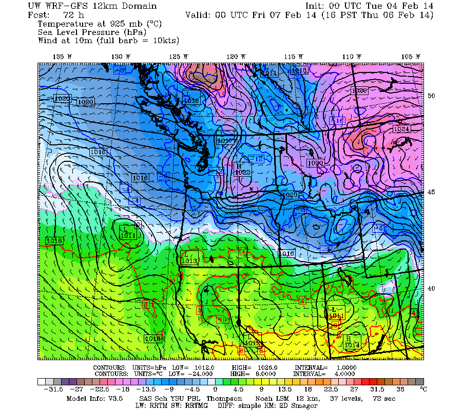
During the past week we have had a situation with cold air over British Columbia and Washington, a zone of large temperature change (a frontal zone) over Oregon, and warmer air over California. To illustrate, the following map shows lower atmosphere temperatures (925 hPa, around 2500 ft up) and sea level pressure at 8 AM on Thursday. Cold (blue) over Washington, warmer (green and orange) over CA, and a big change over Oregon. Cold enough to snow from central Oregon northward.
The official NWS analysis at this time shows the position of the front, and also indicates a frontal wave suggested by the undulation of the front and the low center (see graphic).
Weak disturbances that develop on fronts, or frontal waves, are relatively small scale, are often shallow, and are very difficult to forecast correctly even over land. But in this case, it is even harder because they are forming and evolving over the ocean where our ability to detect and describe small-scale structures are not as good. And the snow events this week have all been associated with such frontal waves and to forecast the snow correctly requires getting their position, size, and motion exactly correct...something current weather prediction technology is still not adequate to deal with.
Let me illustrate the problem. Here is the analysis of sea level pressure and lower atmosphere temperature at 4 PM Thursday during the first Oregon snowstorm. See the low right off the central Oregon coast? This is a good description of the truth.
The 12h forecast for the exact same time has the low, but it is shifted well inland.
The 24h forecast way more.
The 48 hr forecast pushes the low into southern Oregon and is trying to build a new one over the Pacific.
The 72h forecast is hugely different with a low offshore.
And the 96h forecast has no low over Northwest, with cold air spreading down to CA.
Now this is one model. We have many models to look at and until the last day before the Thursday snow they were all over the place with very different solutions. In short, there has been huge uncertainty in the forecasts because the models lacked enough data over the Pacific to tie down the solution. Furthermore, such small scale, fast moving features are inherently hard to forecast.
But why can we forecast snow skillfully in some cases? The reason is that some snow events are associated with different types of evolution, such as when a very large scale warm front approaches cold air over the Northwest. The models can get a handle on such large scale features and we know that with cold air in place, the event will start as snow and turn to rain. You can practically set your clock with such forecasts.
Ah yes....will it snow today or Sunday? Let me tell you what we know for sure. Warmer air and rain will sweep over the region on Monday, ending the cold period for the western lowlands. Guaranteed.
But today/tonight another frontal wave is approaching Oregon and snow is already falling in the Willamette Valley (see radar). But the air mass is warming and rain is being observed over the Oregon coast right now
The lastest WRF model snow forecast for the 24h ending 4 AM Sunday suggests theWillamette Valley snow, lots of snow in the northern Oregon Cascades, snow over SW Washington, with a dusting getting as far north as Seattle. Snow will also spread east of the Cascades as well.
The accumulated snowfall over the next 15 hr from the NOAA HRRR modeling system (for the period ending 10 PM tonight) shows a consistent story:
So if you are in Portland, more snow today for you. Seattle will probably escape from any significant impact, with perhaps a dusting over the southern portions. But as you can imagine, a slight shift northward of the low could change the story a bit for southern Puget Sound.
The European social model is a common vision many European states have for a society that combines economic growth with high living standards and good ...
Subscribe to:
Post Comments (Atom)


No comments:
Post a Comment