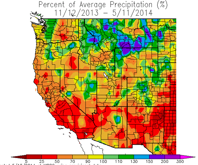
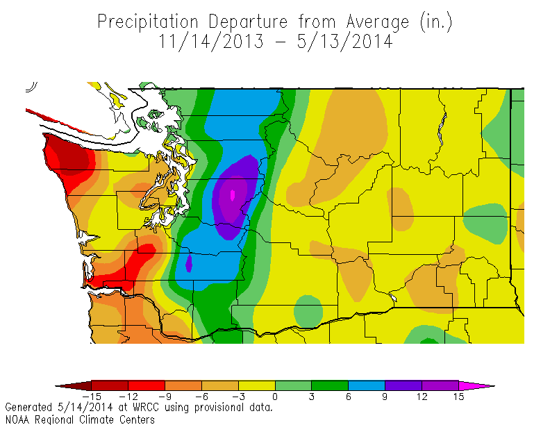
Take a look at this winter's precipitation along the U.S. West Coast from mid-November through mid-May, particularly how much it deviated from normal (the precipitation departure from average). (image below) The most dramatic departure from normal extended from the southern Oregon coast down to central California, with large precipitation deficits (ranging up to 16-20 inches!) also over the Sierra Nevada. You will notice that the Washington Cascades were the wettest place on the map, reaching 12-16 inches above normal. But interestingly, the Washington coast was quite a bit drier than normal, and eastern Washington was a few inches below normal. The northern Rockies were wet.
We can look at the % of normal precipitation for the same period as an alternative (see below). A somewhat similar story but southern California, Arizona, and New Mexico show up as being much drier than normal in terms of percentages: much of region received less than 50% of normal precipitation.
Very strange. What could explain this pattern? If wet storms were more frequent over the Cascades, why was the coast dry?
I suspect I know the answer to this.
The first part of the winter was quite dry over the the entire region and we did not get many strong storms at all. The precipitation turned on during the second half of the winter, starting in early February. And during that period the precipitation was mainly limited to central Oregon northward. The flow was still anomalous with unusual ridging (high pressure) over California and lower than normal pressure over British Columbia. Such a pattern would tend to produce westerly/northwesterly flow over Washington the lower atmosphere, rather than the more typical southwesterly flow.
That is the key.
That is the key.
Westerly flow tends to drop large amounts of precipitation on the windward slopes and crests of north-south oriented high mountain ranges, like the Cascades. But such flow promotes drying east of the Cascade crest as the air is forced to descend and warm. Southwesterly flow produces heavy precipitation along the coast and Olympics, while northwesterly flow is drier. And westerly/northwesterly flow produces descent (and drying) to the east of the Olympics. It all fits. But can we prove it?
I think I know how. Let's examine the flow at around 5000 ft (850 hPa pressure) for the wet period from mid-February though mid-April. Below is the difference from normal of the flow averaged over that period . We call this the height anomaly. As I suspected, the heights were higher than normal (red/orange colors) over CA and southern Oregon and lower than normal to the north. This produced a large north-south gradient in heights (or pressure), which would produce stronger winds than normal over the Northwest from a westerly or northwesterly direction. The black arrows show you the anomalous winds during that period (they are draw parallel to the colored lines). They are from the west to northwest over Washington.
So this explains what happened....with higher heights than normal to our south we had stronger westerly/northwesterly winds than normal, which produce more upslope than normal on the Cascades and more downslope to their lee. Locations to the lee of the Olympics and coastal mountains were also drier.


No comments:
Post a Comment