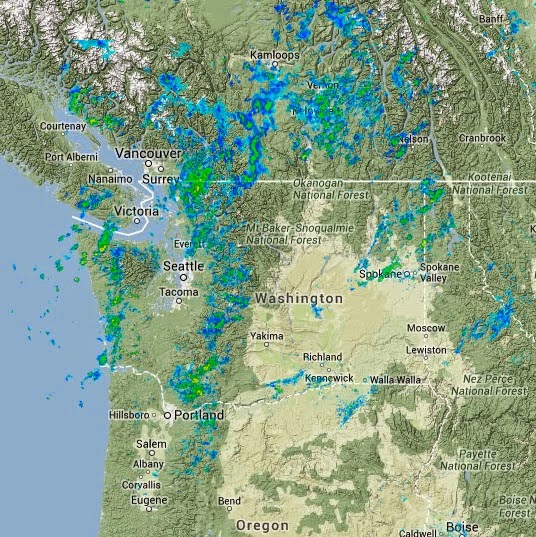
So let me switch into nowcasting...short term prediction....mode. Today looks quite a bit better than expected, particularly if you are in the right places.
Here is the 10 AM radar. Showers are occurring on the windward slopes of the Cascades and coastal mountains as moist, unstable flow is forced to rise. Dry in the Columbia Basin. Some light bands of showers coming in off the ocean and if you look closely there are some showers around Everett...associated with a Puget Sound convergence zone.
A recent visible satellite image shows the shows offshore, enhanced clouds on the windward (western) side of the mountains and a clear indication of the Puget Sound convergence zone north of Seattle. Do you see the enhanced clearing over Seattle and the south Sound? A classic CZ signature.
So you want to decide on your outdoor activity this afternoon? Western slopes of the WA Cascades will be damp and cloudy. Sorry. The convergence zone may strengthen and move southward to Seattle. Here are the 3-h UW WRF forecasts ending 2 PM, 5 PM, and 8 PM today (Monday). Outside of the convergence zone the lowlands look dry...and don't take this forecast as gospel...the phasing and timing of the CZ could be shifted by hours. Watch the radar
A completely independent system is the High Resolution Rapid Refresh run by NOAA. It's one-hour precipitation forecast ending 2 PM and 5 PM are similar to WRF, but a bit drier. Still some convergence zone activity but less near Puget Sound.
So if you are south of Seattle...fire up the grill. If you are in Seattle, watch the weather radar! The convergence zone precipitation is relatively narrow (perhaps 5 miles) and you can time you way to a dry meal.
And the amazing record? Here is a notice released by the Seattle National Weather Service office:
.CLIMATE...THE RAINFALL TOTAL AT SEATTLE-TACOMA AIRPORT WAS 0.22
INCHES SUNDAY. THIS MAKES THE RAINFALL TOTAL SINCE FEBRUARY 1ST
22.87 INCHES. THIS BREAKS THE RECORD FOR THE WETTEST FEBRUARY
THROUGH JULY IN SEATTLE. THE OLD RECORD WAS 22.81 INCHES SET IN
1972.   FELTON/MCDONNAL
You knew this was a wet late winter/spring, particularly mid-February through mid-March. But to beat the Feb-July record in MAY is really notable.


No comments:
Post a Comment