What could be more typical of the Northwest is summer? Low coastal clouds and smoke.
The visible satellite picture this morning says it all, Low clouds along the coast, with some of them pushing inland as far as Shelton and Portland. And smoke...lots of it... spreading as far south as Seattle, with dense smoke over southern Vancouver Island, the Strait of Georgia, Vancouver and vicinity. So if you don't like smoke, go south.
The morning cams from a variety of locations show the murk, particularly in southern BC (see below)
The smoke actually cooled the high temperatures down north of Seattle yesterday by reducing the amount of solar radiation. Here is a plot of the solar radiation measured at the University of Washington yesterday...and Seattle did not get the worst of it. On the left is July 4 and on the right is yesterday. See the difference? One is a smooth curve showing radiation under clear skies, the second has a number of dips and reductions due to the smoke.
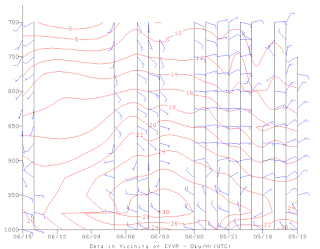
The situation should improve over the lowlands today as the flow has turned more onshore--pushing the smoke eastward. To show this, here is a plot of the winds at Vancouver Airport. Easterly flow yesterday switching to weak southwesterlies today. (red lines are temperature, the y-axis is height in pressure, 700 is around 10,000 ft)
Finally, here is an amazing series of pictures taken by Steve Smith of Orcas Island yesterday...looking north towards Eastsound.
First, a typical summer day.
Followed by a series of pictures starting at 3 PM and ending at 8 PM.
The smoke season has begun over the Northwest and it will continue for a few months.
The European social model is a common vision many European states have for a society that combines economic growth with high living standards and good ...


No comments:
Post a Comment