Let's take a look at a comparison of the temperatures (yellow lines) on both sides of the Cascades (Sea Tac and Yakima) with the normal highs (red lines) and low (blue lines) for the past year. You will see a very similar story at both locations.
Both sites have been much warmer with normal, with high temperatures exceeding the normal highs on most days. It has been crazy warm during the past month, with many days 10-20F above normal. On only a few days did the low temps go below the normal low (with the prime exception occurring early last winter). Although the warmth is most excessive during the last few weeks, we have been in this torrid state for a long time...and last summer was very warm as well.
Here is a thought to keep in mind: the more extreme the weather anomaly, the less likely it is to be caused by human-induced (anthropogenic) global warming. The current situation is mega extreme in terms of our temperatures. The reason this aphorism makes sense is that global warming due to increased greenhouse gases should warm the earth in a progressive, slow way---not in huge jumps. Here in the Northwest, temperature increases have been particularly slow (about 1F over the past century) because of the huge thermal inertia of the Pacific Ocean.
And there is something else: the warming influencing our region is localized and does not have the characteristics of the global warming signal seen in climate models. While the Northwest has been hot and dry, much of the eastern U.S. has been much cooler and wetter than normal. Even the Rockies have been wetter than normal. Global warming would warm them as well. This week I was at a weather conference in Chicago....it was quite chilly there at times.
What is actually going is an amplification of the upper level wave pattern. Now, drop that at a cocktail party and folks will be impressed. The upper level flow, where the jet stream is located, can undulate like a snake, with areas where it slithers northward (a ridge) and others where it projects southward (a trough). During the past year, we have been stuck in a startling persistent pattern with a ridge over the west and a trough over the east.
Here is the height pattern at 500 hPa pressure (about 18,000 ft) at 11 PM Tuesday. Think of it like pressure, with the winds following the lines. Ridge west, trough east.
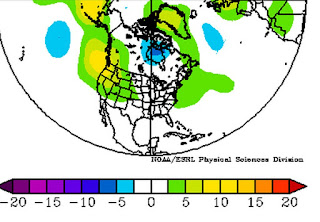
Or we can look at the height anomalies (differences from climatology for the past 30 days). Yellow indicate higher heights than normal (ridging or high pressure). Unusual ridging over the West Coast.
Ridges are associated with sinking motion and warmth. Sunny skies, less precipitation.
And something is amplifying the warmth even more....the Pacific Ocean.
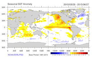
The ridging over the eastern Pacific and West Coast has resulted in warmer than normal waters, something demonstrated in a recent paper by Nick Bond (WA State Climatologist) and others. It seems like high pressure reduces winds and lessens the mixing of cooler water from below the surface. Thus, the eastern Pacific has been 3-6F warmer than normal, which warms the air reaching our region. To demonstrate this, here are the sea surface temperature (SST) anomalies (difference from normal) for the past month...you see the reds and orange colors off our coast? The is warm water. Nick Bond termed a colorful name for it: the BLOB.
The developing El Nino has also contributed to warm water off our coast.
Another way to put this year in perspective is to plot the temperatures over our state for the last 50 years. Here is such a plot of the monthly temperature anomalies (differences from a 30-year normal) for Washington through May 2015. There is overall a weak upward trend over the last 50 years (part of which could be associated with global warming). We are in a temperature spike and June's temperature anomaly would have been larger than May. But a spike is much more suggestive of natural variability, not the progressive warming due to increasing greenhouse gases. The larger the spike, the less likely it is due to greenhouse gas emissions by humans.
The bottom line is that there is no reason to expect that global warming would amplify the upper level wave pattern like this. In fact, the latest research, including some done by one of my graduate students, Matt Brewer, strongly suggests the opposite. Furthermore, a paper by Professor Dennis Hartmann of my department suggests the West Coast ridging can be traced to some warm water in the subtropics, associated with a mode of natural variability over the Pacific.
What we are going through IS very, very unusual. But just because is unusual does not mean humans are behind it.
Will we cool down soon? Probably not, our long-term computer models suggest a warm summer for the Northwest. And a very strong El Nino is developing, which should warm us next winter.
At least your heating bills will be low.


No comments:
Post a Comment