The infrared satellite picture, available 24-h a day, shows that the comma-shaped clouds of the storm are quite high (light shade).
The radar image at 9:48 AM is picking up the offshore circulation, something we could not have seen before the Langley Hill radar was installed near Hoquiam:
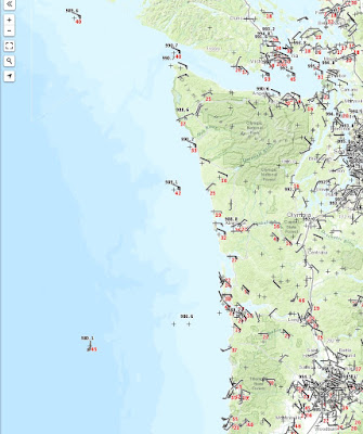
The low center is nearly going over NOAA Buoy 46089, nearly due west of the Columbia bars (see map). The pressure is dropping rapidly there--already down to 980 hPa. This storm is deeper than originally predicted at this time (982-986 hPa). The storm is also moving in faster than forecast by 2-3 hours.
Currently (9AM), winds over the region are not impressive (see plot of winds, wind gusts (red), and pressure). Click to expand. The low is clearly seaward of buoy 46089, where the pressure is 980.1 hPa.
So what about the forecast? The 5 AM WRF prediction for noon shows an elongated, poorly defined low center making landfall on the southern WA coast. Such a distortion works against having the very strongest winds, with the area of large pressure gradient limited to near the Oregon/WA border. But looking at the latest radar loops, I believe this forecast has problems...the storm is staying farther offshore.
The WRF forecast at the time of strongest winds over Puget Sound (about 2 PM PDT) shows sustained winds of 35 knots over Seattle, which would imply 40-55 knot gusts in exposed locations. The low center is just south of Sequim.
But considering the storm's current path, I suspect the winds will be lighter.
There is a modeling system called HRRR that is updated every hour...let see what it shows.
At 11 AM, the low is still offshore...much better.
At 4 PM, the low is over southern Vancouver Island and the pressure gradients are only moderate over Puget Sound. Much more reasonable and implies a much more modest Puget Sound event.
So will it get windy here in Puget Sound? You bet. But I suspect most will only see sustained winds of 20-25 mph with gusts to 35-45 mph. You won't have to wait long to know.
10:50 Addition...the lowest scan angle from the Langley Radar...stunning. Only Langley Hill has this angle (.26 degrees), due to the intervention of Senator Maria Cantwell. You can see the elongated circulation clearly and the fact that this low center is still offshore.
Announcement: Public Talk: Weather Forecasting: From Superstition to Supercomputers
I will be giving a talk on March 16th at 7:30 PM in Kane Hall on the UW campus on the history, science, and technology of weather forecasting as a fundraiser for KPLU. I will give you an insider's view of the amazing story of of weather forecasting's evolution from folk wisdom to a quantitative science using supercomputers. General admission tickets are $25.00, with higher priced reserved seating and VIP tickets (including dinner) available. If you are interested in purchasing tickets, you can sign up here
I will be giving a talk on March 16th at 7:30 PM in Kane Hall on the UW campus on the history, science, and technology of weather forecasting as a fundraiser for KPLU. I will give you an insider's view of the amazing story of of weather forecasting's evolution from folk wisdom to a quantitative science using supercomputers. General admission tickets are $25.00, with higher priced reserved seating and VIP tickets (including dinner) available. If you are interested in purchasing tickets, you can sign up here


No comments:
Post a Comment