
As typical in spring, the passage of a front and the veering of winds towards the west along the coast, resulted in the development of a strong Puget Sound convergence zone, with intense precipitation over central and northern Puget Sound (see image). In contrast, there is bright sun and clear skies to the lee of the mountains of Vancouver Island and the Olympics. The advantage of the Northwest...you can choose your weather.

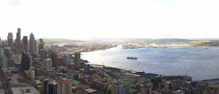
Here are shots from the Space Needle Cam at 9:20 AM. Heavy rain to the north and sun to the south. (North, West, South). Classic. Pick your weather.


But the big weather story this week is the development of a huge ridge of high pressure over the eastern Pacific. Let me show you the upper level (500 hPa) forecasts of the UW WRF modeling system.
First on Tuesday at 5 AM. Wow. Mega ridge with troughs on its flank. This is called an omega block and is very stable.

Thursday at 4AM, the ridge is still strong and has moved towards the coast.

Friday morning, still there.

Now, this is one model run...can we trust it? The way to tell is to look at ensembles of many forecast runs. One application of ensembles is to look at the ensemble mean, which typically is more skillful than any individual member. The average height anomaly at 500 hPa (the average difference of the ensemble members from normal) for Wednesday afternoon shows a huge positive anomaly...much higher than normal, over the eastern Pacific.

Another way is look at spaghetti maps, in which height lines from all the ensemble members are plotted. Here is such map for Wednesday at 5 PM. Virtually all the members are going for the ridge. This prediction looks solid.

The implications of this predicted eastern Pacific ridge is profound, with warm temperatures and sunny skies. Here is the latest forecasts from weather.com. Mid to upper 60s for much of the upcoming week. Enjoy.


.gif)

No comments:
Post a Comment