So with cool temperatures aloft and strong warming at the surface, a large vertical temperature gradient (or lapse rate) developed, one that allows the lower atmosphere to destabilize and convect.
Yes, just like in your hot cereal, when you rev up the heat, the cereal starts to convect--some cereal moving up, some moving down. Convection results when temperature in a fluid decreases rapidly in height. In the case of a dry atmosphere, the temperature must decrease by at least 9.8C per kilometer.

In the atmosphere today, instead of upward and downward convection currents in the oatmeal, we have convecting air parcels, with clouds (cumulus) forming with the upward motion. Today's satellite picture documented the convecting action. At 7:40 AM, there was a lot of layered (stratiform) low clouds over our region (see satellite picture). These are generally stable clouds without much vertical development.

The the strong late-April sun did its magic over land during the morning and that warming, coupled with cool temperatures above, caused instability and convection over land. The satellite image at 12:15 PM shows this clearly in the puff-ball looking clouds. Over our coastal waters it was virtually clear....same with the Strait of Juan de Fuca. The water surface did not heat up.

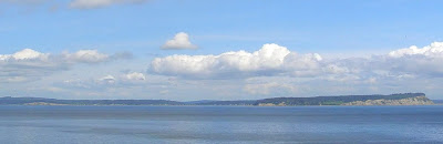
The shallow nature of the convection was evident in local weather cams, such as my favorite SkunkBay Weather cam on the north side of the Kitsap Peninsula (see below)
And for those of you who like to have plenty of water during the summer, there is very good news. The Yakima River reservoir system, so critical for agriculture in the Yakima Valley, has now reached the typical full level, but nearly two months earlier than normal (see image)

The same thing is true for the City of Seattle reservoirs (red line below).

There is still plenty of snow to melt int the mountains, unlike last year, so things look very good regarding water for this summer.


No comments:
Post a Comment