Sunday, December 8, 2013

Snow and Freezing Rain Tomorrow?

 6:30 AM Update

The coastal radar shows a weak area of snow showers moving over Hoquiam and the SW WA coast and moving inland over SW WA (see echo).  Very light stuff.   NOTHING ELSE OUT THERE. So some light snow showers over SW WA is all that we will see this morning.  Update for the evening commute and overnight at noon.  Could be snow showers this evening.


The forecast for Monday is a very difficult one.  

We will have air that is quite cold enough to support snow tomorrow morning.  A very weak weather disturbance will approach during the mid afternoon and will bring some light precipitation to the area.  As the disturbance moves through temperatures will begin to warm as increased onshore flow occurs.  By Tuesday morning commute time it will probably be warm enough for rain over Seattle, with snow holding a bit longer over NW WA.

So for those of your worried about driving to work tomorrow, the morning commute will be fine.  No problems at all.  Enjoy.

South Seattle should be substantially rain shadowed (or snow shadowed in this case). So if snow falls, it probably will be heavier in the north part of the city--but still not more than an inch.  Could easily be much less.  As the temperatures warm up aloft, we might see a few hours of freezing rain.

To illustrate, here is the 24 hr precipitation and snowfall ending 4 AM on Tuesday AM. The mountains will get snow ...guaranteed and NEEDED.  NW Washington including Everett to Bellingham to the San Juans will get perhaps an inch. Between the rain shadowing in NW flow and warming, Seattle to the Kitsap will not get much...perhaps 1/4-1/2 inch at most.  Or virtually nothing.


 Not a big event...but any snow in our area can cause problems.  And we could get a few hours of freezing rain.  God knows what the TV stations will make of it!   We will have a much better handle on this tomorrow..I will do a NOWCAST around noon. 

Temperatures are already warming quickly aloft.  Take a look at the wind and temperature above Seattle Tacoma Airport. At around 5000 ft (850 hPa on chart)  the temperatures have warmed from -12 to -6C (that is a warming of around 11F). 

Watch the radar tomorrow...you will see in real time what is happening.  Precipitation amounts will be everything.  No precipitation...no worries.  If you see it coming in when you need to be driving or biking...you might get an early start.  No big blizzard, but roads can get slick with a little snow.  Sea-Tac Airport is 4 F warmer than the same time yesterday--that is true for many local stations.   Changes are beginning....

Finally, for those in my ATMS 101 class taking their final exam tomorrow at 8:30 AM....there are no snow excuses.  Be there!

Which has Worse Air? A Hazy Airport Smoking Lounge or a Major Chinese City?

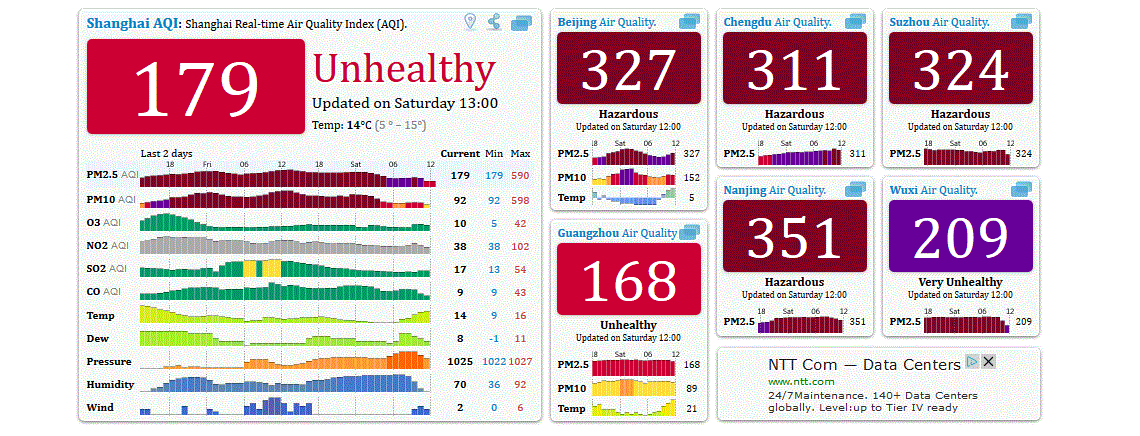
Sometimes you learn a fact that is just stunning.   The poor air quality of Chinese cities is well known, but here is an amazing piece of informaton.  The amount of small particulates in the air in major Chinese cities last week was WORSE and sometimes MUCH WORSE than smoking lounges in airports.

You know those smoking lounges.  Laden with smoke--you start coughing if you enter one. Hazy.


Recently, the U.S. Center for Disease Control (CDC) did a study of the particulate levels in major airport smoking lounges.  They reported the amount of small particles of less than 2.5 microns (millionth of a meter) in size.  These kinds of particles are particularly dangerous because they are small enough to move deep into the lungs.  The result is lessened lung function, asthma, and even death for vulnerable groups exposed long enough.  Nasty stuff.

The study found that the average airport  lounge had a particulate level of 188.7 micrograms per cubic meter. The average small particle level in the four smoking-permitted bars and restaurants was 276.9 micrograms per cubic meter.   Contrast that to the average level in smoke-free airports: 8 micrograms per cubic meter.   Or our air right now in the Northwest, say Queen Anne Hill in Seattle (graphic below).   You can see that this month that the small particle levels there ranged by from around 2 to 14 micrograms per cubic meter.  EPA regulations say that U.S. cities are out of attainment for air quality if the small particulate level is above 12 micrograms per cubic meter averaged over a year.

Now prepare to be shocked.  Here is a snapshot of the small particulate levels at some Chinese cities yesterday.  Many were over 300 micrograms per cubic meter at that time....WORST than the smoking lounges or the smoky bars.  And it is worse than that.  Earlier this week Shanghai got over 600 micrograms per cubic meter.


Think about that...more than twice as polluted as a horrible airport smoking lounge.  No wonder Ambassadar Locke wants to get his family out of there.  Can't blame him.


To get some intuition about the problem, here are pictures of Shanghai during a clean period and this week.  You can guess which one is which.


There are many reasons to try to reduce the use of fossil fuels, but certainly the air quality implications of burning oil and coal are some of them.  China can do a great deal to clean up their atmosphere (including burning cleaner fuels and insisting on more pollution controls).  But they need energy to support their growing economy and improvement of the living standards of their people, and non-carbon energy sources (e.g., hydro, nuclear, wind, solar) will have to take on a larger role.  This air pollution is taking a horrible toll on the health of the Chinese people.

Thanks to Professor Joel Thornton for noting to me the smoker's lounge vs. China air pollution equivalence.

Friday, December 6, 2013

Snow Hits Southwest Washington and Oregon and a Reverse Convergence Zone

As predicted by the models for several days, a low moved southward along the Northwest coast, bringing light snow to the coast and SW Washington and much heavier amounts to the western interior of Oregon.   A light dusting spread last night into the Kitsap Peninsula from Olympia southward. 

Here is the visible satellite around noon on Friday.  You can see the swirl of clouds associated with the low off of northern Oregon.

The amount of snow that has fallen across the region has varied substantially as of 12:30 PM.  Four inches were on the ground in Salem, Oregon at that time (6 inches at 4 PM) and I have an unofficial report of 9 inches near Corvallis, Oregon.   Take a look what Oregon State in Covallis looked like today:

 Here are a few cam shots on I5 near Eugene--this does not look like pleasant travel.

 The Washington Coast got around 1/2 inch as did some locations around SW Washington.

As the low moved south of Washington, easterly flow has increased over Washington State--thus air is approaching the Olympics through depth from an unusual direction...from the east.  A plot of the winds over Seattle shows this change clearly (time increases to the left, the y axis is pressure, red lines are temperature).  The atmosphere is cooling and the winds are easterly to 700 hPa (roughly 10,000 ft)

With easterly winds approaching the Olympics we are getting an interesting phenomenon...a convergence zone on the WESTERN side of the mountains, with an accompanying band of clouds and even some precipitation.  Many are familiar with the Puget Sound convergence zone, in which westerly winds approach the Olympics, move around the Olympics at low levels, and converge over Puget Sound producing a band of clouds and precipitation (see graphic).

Now reverse the winds and you get a convergence zone to the west of the Olympics.  

Let me prove it to you.  Here is a MODIS visible satellite picture at 12:10 PM Friday.  You see the band of clouds extending southwestward from the Olympics?...that's it.  There are also clouds north of the Olympics, produced by the NE flow coming out of the Fraser River gap and passing over Bellingham and the San Juans  before being forced to rise by the Olympics.  Perhaps some snow over south Port Angeles!

 We can get an even better view of the offshore convergence zone by viewing an image from the Langley Hill radar in Hoquiam (see below).  An amazing image...you can see a narrow plume of precipitation in the coastal convergence zone.

Today, our models are good enough to forecast such features. Here is an 8 hour forecast of clouds by the UW WRF (1.3 km resolution).   Both the coastal convergence zone and the upslope clouds south of Port Angeles is in there.  We have come a long way.

A model forecast of the winds  at 1 PM show the converging winds west of the Cascades.


The coldest temperatures are coming the next two nights...here is the forecast temperature at 7AM Saturday AM.  16-20F over many locations on the eastside of Puget Sound.  Single digits and negative temps in eastern WA.  Wind chills in the mountains will be brutal...below -20F will not be uncommon.  Be prepared if you go up there.


Question
Are you in venture capital/private equity and have an office in the Bay Area, or knows someone who does?
If so, I have a question for you. Please send me an email (cmass at uw.edu) ....thanks, cliff


Thursday, December 5, 2013

2014 Magazine Beauty Pageant Model Talent Search


This is the official 2014 Ripping Runways Magazine Model Search Auditions that will be running until December 16th  2014 for each hot online issue this year, featuring the most beautiful and hottest female models and female talent worldwide that are ready to shine among some real up and coming top female models and female talent that are already making their names well known in the fashion and entertainment industry.


Wouldn't it be amazing if you were a top female model or famous female entertainer making millions of dollars and everybody knew from magazine covers and TV appearances?


But you are not a top female model or famous female entertainer, you are a person that needs some exposure to become a top female model or famous female entertainer, and we can help you if you are serious about pursuing a career in the fashion or entertainment industry.


Imagine what it would be like if you were a professional female model or female entertainer getting paid for a job that you love doing, just think how exciting your life would be and all the attention you would receive from fans, the media, and from everybody that knows your face.


If you are a hot aspiring model and you have professional photos of creatively posing, you are serious about pursuing a career in modeling, entertainment, or acting, and you feel that you are prepared and ready for Ripping Runways Magazine to give you some great added exposure that could further your career in the fashion, TV and entertainment industry, then this audition is what you are looking for.


You probably know that it takes a lot of hard work and persistence to be a professional model or entertainer, but nothing is impossible if you are ready to put in the effort it takes to see your dreams of becoming a professional female model or female entertainer become a reality.


Ripping Runways Magazine would like to help you experience the excitement of being featured in this Internationally known online magazine, that could possibly
further your career in TV castings, Movie castings, Video Castings, Paid Photo
Shoots, and features in other magazines, just to name a few possibilities.


Imagine what you could do if you were a professional top model or famous female entertainer, just think about it, are you beginning to see all the potential and possibilities?


So now you have to choose between sitting there and not following your dreams of becoming a professional female model or female entertainer, or you can take the necessary actions to start the process of achieving your dreams to become a professional female model or female entertainer, by auditioning for the next issue of Ripping Runways Magazine online.


The fact that you are still reading is a sign that you are obviously very interested in becoming a professional female model or female entertainer that would enjoy some worldwide exposure, this is the reason why you should take advantage of this audition and submit as many recent professional photos of yourself as you like, The more photos you submit the better chance you have of being selected to be feature in the 2013 Ripping Runways Magazine Christmas Issue,

 but you must submit no less than 4 of your hottest professional high quality headshot photos with no logos and 6 of your hottest professional high quality full body shot photos in dress clothing, casual clothing, and swimwear or lingerie with no logos. (Do not submit camera phone photos, do not submit photos with photographer signatures or logos, do not submit low quality photos, or photos that are older than 9 months.) please visit website for details and audition form at: http://rippingrunways.wix.com/rippingrunways


Ripping Runways Magazine is accepting professional promo kits, photos, bios, and videos, from female aspiring models, professional models, female singers, dancers, Deejays, designers, female rappers, female fashion bloggers, photographers, hairstylists, and makeup artists, interested in being featured in our next issue of our internationally known Ripping Runways Magazine online, please visit website for details and audition form at: http://rippingrunways.wix.com/rippingrunways


If you are a photographer, hairstylist, makeup artist, actor, or designer, please submit your promotional kit with 10 photos of your work, your bio with contact information, and any video or video links. Please visit website for details and audition form at: http://rippingrunways.wix.com/rippingrunways


2014 Ripping Runways Magazine Model Talent Search


2014 Ripping Runways Magazine Model Talent Search


A new year is just around the corner and that means all new opportunities for up and coming male and female models to make their break in the world of international modeling. The Ripping Runways Model Search is gearing up to kick off again and aspiring modeling talents can submit themselves today for consideration for several exciting projects.


Ripping Runways is the world’s premiere online fashion magazine and it is responsible for discovering some of the biggest talents in the industry year after year.


The talent scouts for The Ripping Runways Magazine Model and Fashion Talent Search are on the lookout for the most fabulous female models from across the globe to featured in their outstanding publications that are seen by millions each day and have become one of the strongest voices in not only fashion and modeling but all aspects of the entertainment industry.


If you are an aspiring print, catalog, campaign, fitness, tradeshow, public relations or showroom model, this could be your shot at gaining worldwide exposure and taking your career to the next level. This is one of the truly incredible modeling events of the year and one that you absolutely have to be a part of.


Submissions for the latest Ripping Runways Magazine Model and Fashion Talent Search are happening very shortly and interested female models and female talent can submit themselves today by sending no less than 10 of your best professional modeling photos with no logos from the past nine months and your information to them by email on their website at: http://rippingrunways.wix.com/rippingrunways


Audition forms for upcoming casting calls can be filled out here http://rippingrunways.wix.com/rippingrunways


More Ripping Runways Magazine news and updates will be posted here as they become available so stay tuned for more details on this fantastic opportunity and leave a comment below and tell us why you are ready to be the next all-star talent found in The Ripping Runways Magazine Model and Fashion Talent Search.

Wednesday, December 4, 2013

Cold Facts and Coastal/Oregon Snow


We are now experiencing our coldest weather since January, with temperatures falling below zero in "favored" spots of eastern Washington and Oregon.  Snow is coming to the Northwest during the next two days, but unfortunately will miss most of Washington.

But first, this morning there was an unusual sight:  a line of clouds down the center of Puget Sound (see picture from the UW web cam facing the Olympics).  The cause?  The cold air!


Last night we had a land breeze on both sides of the Sound.  A land breeze occurs when the land is colder than the water, generally by at least 5-10F.   Last night that happened:  the water temperature is roughly 50F while the land temperatures dropped into the 20s.  Air from the cold land moves towards the water.   The land breezes on both sides of the Sound converged over the central Sound and rose, producing a line of clouds. You can see a hint of this from the winds taken over Puget Sound this morning by the Washington State ferry traveling between Edmonds and Kingston around 8:30 AM (see below)

The next map shows you the low temperatures across the region last night.  Some of the coldest temperatures were at Pullman (-3F) and in the nearby Blue Mountains.  Why was it so much colder at Pullman than say Moses Lake?   The answer is found in a satellite image taken this morning:  Pullman had snow on the ground (see picture below).


Snow covered NW Oregon and SE Washington.  Snow is associated with cold temperatures:  it reflects the sun during the day and is a very effective emitter in the infrared.   And it can insulate the lower atmosphere from warm ground.


Now let's talk forecast.  An upper level trough is moving southward around the high, causing upward motion, clouds, and precipitation (see map at 10 PM Thursday at 500 hPa).  Associated with the

upper trough is a low center at and near the surface (see surface map).  
 The frustrating thing for snow lovers is that the low is passing too far offshore to bring snow to most of Washington, perhaps light snow on the WA coast and moderate snow over central and southern Oregon as the low swings eastward south of us.  If the low was one hundred miles to the east and Seattle would be white.  Here is the projected 48h snowfall ending Saturday at 4 AM.  Oregon is nearly COMPLETELY covered with snow, with the  exception of Portland and Columbia Gorge.  Northern CA gets snow.   Just not fair.

 Then you expect dry and cold conditions through the weekend.   One notable weather feature:  very strong winds are expected on Friday and Saturday downstream of the Fraser River Gap--we are talking Bellingham, San Juans, and the neighborhood.  Here are the gusts at 4 PM Friday.  50 kts over the Strait of Georgia from the NE and strong easterlies over the Pacific and Strait.

And expect windy conditions along the western slopes of the Cascades, particular in Enumclaw, Black Diamond, the Issaquah Highlands, and North Bend.

Announcement

Are you in venture capital/private equity and have an office in the Bay Area, or knows someone who does?
If so, I have a question for you. Please send me an email (cmass at uw.edu) ....thanks, cliff


Monday, December 2, 2013

Nowcast: No Snow Problems for Evening Commute or Seahawks Game

I have gotten a number of emails from folks worrying about snow during the commute and after the Seahawk's game in Seattle tonight.

There will be no problems during the commute tonight and I don't think driving home from the game will be much of an issue.  But don't be surprised if some snow flurries/dusting occurs around 9-10 PM or so.

Right now (4:45 PM), the SnowWatch web site shows that air temps around 40 and the road temps are in the mid-40s (see graphic)

Cold air has just started to push out of the Fraser Gap into Bellingham, where snow began at 4:42 PM.  It is very light and will take 4-5 hrs to reach Seattle.  The latest radar shows two major local bands of precipitation over the lowlands: a convergence zone band over Snohomish County and northern King County and a band south of Bellingham associated with the Fraser River outflow.  The latter band will move south in time.  It may rev up when it interacts with the convergence zone band, which should weaken in time.    Anyway, there should be a line of weak convective showers leading the northerlies that pushes southward into Puget Sound during the middle evening.


According to the Snowwatch temperature information, the freezing level was at around 2000 ft at 4 PM.   The snow level is about 1000 ft below that.  The air is cooling, so the snow level will probably get to around 500 ft by 10 PM.   So near sea level I would expect the precipitation to start as rain as the band comes through.  Over time, melting and evaporation could help bring some flakes to near sea level, but road surfaces will be warm.   And the snow will move through quickly.

Bottom line:  no real threat at sea level even if the worst scenario occurs.  So enjoy shopping or going to the Seahawks game...the weather won't stop you....


PS:  There are more chances of snow in our future!


Announcement

Are you in venture capital/private equity and have an office in the Bay Area, or knows someone who does?
If so, I have a question for you. Please send me an email (cmass at uw.edu) ....thanks, cliff

Popular Posts