Monday, February 9, 2015

Why is the Northwest Warm and California Dry? Part 1.

Many Northwest residents are asking the same questions:

Why is it so warm this winter?
Why so little snowfall in the mountains?
Is the warmth and snow drought connected with human-caused global warming?
Is there a connection with the cold and snow over the eastern U.S. and our anomalous weather?
Or with the drought in California?
What is the role of blob (the region of warm water off our coast the last year)?

Today the Seattle Times front page headline called out the poor Cascade snowpack and showed a picture of the Snoqualmie Summit ski area that would bring depression to any ski enthusiast. And media all over the country are asking similar questions.

Picture courtesy of the Seattle Times

Fortunately, there are some solid answers to these questions.  Combining some basic meteorology, logic, and the results from a number of new research studies, this and my next blog will attempt to provide a coherent picture of what we know.

But for the impatient and the lovers of executive summaries here is the gist of it:

Yes, they are all interconnected.
Natural variability is the probable cause.
There is no reason to expect that anthropogenic (human-caused) global warming has much to do with it.

So what is going on this winter?

It is quite easy to explain the proximate cause of the warmth over the Northwest, the drought over California, and the cold/snow over the eastern U.S.    They are all caused by the same basic phenomenon:  a high amplitude upper level pattern with a persistent ridge over the West Coast and a trough over the eastern U.S.

You can see this in a map of the difference from normal (the anomaly) for the last 90 days for 500 hPa heights (think of is like pressure at around 18,000 ft).  Above-normal heights (ridging or high pressure) are indicated by red colors and below normal heights (troughing) by blue colors.  You can see how disturbed the atmosphere is over and near North America.

Want to see what this pattern looks like on a specific day?...here is the forecast for this Thursday, a day that will probably hit 60F in Seattle and bring another snowstorm to the Northeast!  Big ridge over the western U.S. and trough in the east.  I am tired of this pattern.


In general, ridges bring dry conditions and warmth, while troughs are associated with cooler, wetter situations.  Here is the surface air temperature anomaly (again difference from normal) for the last 90 days across the U.S>.  Warm in the west under the influence of the ridge and cool in the east with the trough.

Why do ridges and troughs influence weather?  Because ridges have sinking air, which kills clouds and air warms as it sinks.  Also, the southwesterly flow on the west side of ridges brings up warm air from the south.   Troughs have rising motion, which cools the air and causes clouds and precipitation, and the northwesterly flow on the west side of troughs bring cooler air from the north.

Here in the Northwest we have gone between dry, warm periods and wet, warm periods.  And it all has to do with the position of the persistent western  ridge.  Look at this schematic based on the upper level map I showed earlier. Nice ridge along the west coast.  The arrows indicate the flow direction at this level and note the winds are parallel to the lines.  West of the ridge axis there is moist southwesterly flow.   If the ridge shifts a bit to the east or if its amplitude weakens a bit, the Northwest gets into the moist southwesterly flow--putting us into a wet, atmospheric river situation. Stronger ridge or positioned as shown below, we are warm and dry.   California, located farther south, is far less likely to be hit by the moist, southwesterly flow and thus they are in a big drought.


You can see this effect on the precipitation at Seattle-Tacoma Airport the past 4 weeks (see below).  Long period of no rain (big ridge) interrupted by shorter period of intense rain (atmospheric rivers on the western side of the ridge). The blue line is the average situation.
Could this contrasting pattern be caused by global warming?  

Averaged over the U.S., the temperature departures from normal are about zero (warmer west, cooler east).  There is no uniform warming going on--so it doesn't appear to be associated with a large scale global warming signal.  Folks on the East Coast might be complaining about global cooling with record-breaking snow hitting the Northeast, particularly around Boston.

Some investigators have claimed this pattern of enhanced ridging in the west and stronger troughing in east is the result of global warming, but such causality is very unlikely.  First, the papers claiming such a connection have been pretty much disproven, with serious faults in their methodology being shown.  (Many of these papers were cited in newspapers and by politicians last year when the polar vortex was in vogue).  Second, their is no long-term trend in such wave patterns, which one would expect if global warming was the culprit.  Third, global warming simulations of the future climate under global warming do not indicate higher amplitudes of atmospheric waves.  There are other reasons, but you get the picture.  It is unlikely that global warming caused by increases in CO2 are causing this pattern.

But what is the origin of this bizarre pattern of ridging in the west and troughing in the east?  I will take that up in the next blog!


The Pacific Northwest Weather Workshop

Interested in attending the big local weather workshop of the region?  The Pacific Northwest Weather Workshop will be held in Seattle at the NOAA facility on February 27-28th.   Everyone is invited and the majority of talks are accessible to laypeople.  To attend you have to register or they won't let you in the gate.  There will be a major session on the Oso landslide.  There is a registration fee that covers refreshments and food, and special student pricing.  If interested, check out this website.


Climate Change and the Pacific Northwest

I will be giving a provocative talk on this subject on March 11th at 7:30 PM Kane Hall on the UW campus in Seattle.  Sponsored by local public radio station KPLU, tickets for this event can be secured at this web site.

Saturday, February 7, 2015

Is Winter Over?

Bulbs have been pushing out of the ground for weeks, cherry blossoms are bursting open at some locations on the UW campus, forsythia are starting to flower, weeds are beginning to grow, and the temperatures are at least 1-1.5 months ahead of normal.  Skiing is reminiscent of late April conditions.

Is winter over?

In one sense, the answer is yes.  Meteorological winter ends roughly the third week of February in western Washington.   After that it is difficult to get the really big winter weather events:  record floods, historic windstorm, big lowland snow storms.

We are now close enough to that period to know that it is unlikely that we will get a major event before the typical transition to spring.  The persistent ridging that has been the hallmark of this winter is not going anywhere.  To illustrate, here is the forecast upper level (500 hPa) weather chart for next Tuesday at 4 PM.  Big ridge.  Again.


But anyone who has forecast around here for a while, knows that there have been many warm/dry early winters that have been followed by wet/cool late winters/early springs.

Last year was a good example, with the atmospheric tap turning on the second week of February, resulting in a huge increase in snowpack and a near-record wet period---which may have contributed to the Oso landslide.

And never forget that the Cascade snowpack typically increases until roughly April 1st, as illustrated by the following example at Stevens Pass.  The green line is the average snowpack there and the black line is this year. As shown by the red line, it has been worse.


But let me be clear, I am not optimistic for the remainder of this year and virtually every tool at my disposal suggests that the preternatural warmth will continue.

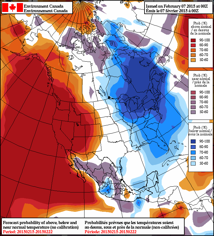
Every long-range forecasting model suggests warmth will continue, as will the associated ridging. To illustrate, here is the forecast temperatures from the North American Ensemble Forecasting System (NAEFS), that combines the long-range model output from the U.S. and Canadian Centers for Feb 15-22nd showing the percentage chance of being above or below normal for that period.   They are 90-100% sure it will be warmer than normal.  They don't get any more certain than that.


And lets take a look at the National Weather Service's Climate Forecast System predictions for the next three months for surface air temperature (actually the difference from normal--the anomalies).  Amazing. A HUGE WARM ANOMALY over our region.  And these anomalies are very statistically significant.    My confidence in this forecast is strengthened by the fact that is probably the result of a relatively slowly changing atmospheric circulation variation that is connected with slowly varying sea surface temperatures in the Pacific (more on that in a future blog).  Note that eastern U.S. is colder than normal.  This is not some kind of global warming where everyone experiences higher temperatures.
Finally, let me note that there is an intimate connection between persistent  West Coast ridging (high pressure) and the heavy rains (associated with atmospheric rivers).  There is a reason we have gone between extended dry periods interrupted by heavy rain.

When the ridge is over us, we are dry.  But if it slips to our east a bit, we move into warm, wet southwesterly flow.   The example below for Friday night at 7 PM (weather map at 300 hPa) illustrates this situation. The colors are wind speed and the winds are parallel to the height lines.


The Pacific Northwest Weather Workshop

Interested in attending the big local weather workshop of the region?  The Pacific Northwest Weather Workshop will be held in Seattle at the NOAA facility on February 27-28th.   Everyone is invited and the majority of talks are accessible to laypeople.  To attend you have to register or they won't let you in the gate.  There will be a major session on the Oso landslide.  There is a registration fee that covers refreshments and food, and special student pricing.  If interested, check out this website.


Climate Change and the Pacific Northwest

I will be giving a provocative talk on this subject on March 11th at 7:30 PM Kane Hall on the UW campus in Seattle.  Sponsored by local public radio station KPLU, tickets for this event can be secured at this web site.


                         Perhaps groundhogs are not very skillful in predicting Northwest weather

Friday, February 6, 2015

Magazine Casting Calls 2015 - Out Next Magazine Model Casting Calls 2015


Out Next Fashion Magazine Model Casting Calls 2015

For Clothing Designers, Fashion Stylists, Female and Male Creative Trendy Dressing Teens and Young Adults Ages 17-30, That Could Possibly Set a New and Unique Stylish Fashion Trend Just By The Way You Currently Dress or Style Your Hair.


The International Beauty Movement is currently casting aspiring trendy dressing male and female models, Clothing Designers, and Fashion Stylists with unique looks that also dress unique but stylish for “Out Next Fashion Magazine” to feature in each 2015 issue of this highly anticipated fashion setting magazine that will debut its first issue online in April 2015.


Konscious Money Entertainment Group Creator of the International Beauty Movement has created a strong presence in both the entertainment and fashion industry with it’s internationally known Ripping Runways Magazine publication, Salon Savvy Magazine For Hair Stylists and Makeup Artists, and Girl 9 Magazine For Men, and as a result, Konscious Money Entertainment and Ripping Runways Magazine is responsible for featuring some of the hottest and most beautiful female models and beauty pageant winners worldwide since 2012.


Out Next Magazine will be dedicated to trendy dressing male and female aspiring models Clothing Designers, Fashion Stylists and professional models worldwide

ages 17-30 that have a unique look and a unique style of dressing with an attitude that matches their dress unique code.


So everyone submitting to this casting call will have to be very creative, very serious, committed to unique fashion, and have a unique look that is worth featuring in an international trend setting fashion magazine.


Fashion Photographers, Clothing Designers, and Fashion Stylists we look forward to seeing your best work.


If you are selected, your unique style of dressing will win you a pictorial feature in this hot and highly anticipated International fashion magazine that will be seen by thousands of people daily online, including fashion and entertainment insiders that are always looking for the next hot trend or hot aspiring model.


Being selected to be a featured trend setting model in Out Next Magazine will be one big step in building a great modeling portfolio, and the perfect opportunity to take your career to the next level, showcase your unique talent for creating fashion trends on a global stage, which will also expand your career, as you gain worldwide exposure for your unique look, expand your professional portfolio in the fashion and entertainment industry, and increase your opportunity of  having your talent of unique style of dressing recognized and seen by thousands of people daily including fashion industry and entertainment industry insiders worldwide.


To apply for consideration as a female or male trend setting fashion model ages 17-30, fashion photographer, clothing designer, or fashion stylist you will need to submit a professionally written bio with your contact information and 8 or more recent professional high resolution photos, please remember you must submit at least 8 or more of your hottest and most recent professional high resolution photos (that are no older than 12 months) with no writing on them, no logos, or photo signatures to qualify for this amazing print magazine contest.


Submit professional photos and bio to: outnextmagazine@aol.com


All photos submitted will be evaluated on creative posing, unique trendy style of dressing, photo shoot location, and unique look.


PLEASE DO NOT SUBMIT THE FOLLOWING TYPES OF PHOTOS BELOW:


We do not accept photos that are older than 12 months, we do not accept camera phone photos, we do not accept photos with more than one model in it, we do not accept photos posted on other websites, we do not accept low resolution photos, we do not accept photos with writing on them, logos, or photographer signatures, and we do not accept personal photos that are taken in your home, we do not accept photos that are collages or have effects, or have borders added to them, so please do not submit none of the above or your photos will not be considered.


You can visit one of our websites below

to fill out an audition form:


International Beauty Movement:


Salon Savvy Magazine:


Ripping Runways Magazine:


Girl 9 Magazine:


Konscious Money Entertainment Group:


You can read our hot fashion magazines at:


Ripping Runways Online Magazine:


Girl 9 Online Magazine:


http://issuu.com/rippingrunways/docs/2014_girl_9_magazine_christmas_issu/1


Salon Savvy Online Magazine:


Please visit our casting call link to view all of our current casting calls for female models and stylists at: http://rippingrunways.blogspot.com/


Magazine Casting Calls 2015 For Girl 9 Lingerie Magazine


The International Beauty Movement

Present its Magazine Casting Calls 2015

and Model Search 2015 For Girl 9 Magazine


Who Wants To Be a Female Lingerie/Bikini Print Model Featured In An International Online Magazine That’s Read By Thousands of People Daily?


Magazine Casting Calls 2015 For Girl 9 Magazine For Men

The Internationally Known Lingerie and Bikini Magazine For Men with over a million readers online is brought to you by the International Beauty Movement, who also publishes Ripping Runways Magazine, Salon Savvy Magazine, Project Couture Magazine, and Out Next Magazine, is now casting beautiful eye catching aspiring female lingerie and bikini print models worldwide for the next issue of Girl 9 Magazine For Men.


If you are a beautiful female with a beautiful body that  deserves to be in a Mens Magazine that’s read by thousands of people each day and you are looking for the perfect opportunity to take your modeling career to the next level, expand your modeling career as a print model, gain worldwide exposure, expand your modeling portfolio by being published in a popular internationally known online magazine, and increase your opportunity of  being seen by fashion industry insiders and entertainment industry insiders worldwide, then you will want to submit your professional lingerie/bikini photo portfolio to this casting call for the opportunity of the year and an opportunity that could create high paying jobs for you in the fashion or entertainment industry.


If you are a beautiful female aspiring bikini print model, lingerie print model, eye candy print model, fitness print model, or vixen print model age 18-35 that has been searching all over the Internet for modeling opportunities that can take your modeling career to the next, then you have come to the right place.

We are seeking Asian models, Indonesian models, Ethnic models, African models, European models, Latina models, Indian models, Polynesian models, Russian Models, African American models, White models, Italian models, and Mixed Race models.

 If you are  interested in being featured in an Internationally known Magazine for men that features the  hottest lingerie and bikini models worldwide and also give you the opportunity to  take your modeling career to the next level that not only builds a great professional modeling portfolio for you, but also give you worldwide exposure that you will need to build a reputable modeling portfolio that increases your chances of gaining high paying job opportunities in the fashion and entertainment industry.


To qualify for this amazing modeling opportunity of the year, you must submit a bio or introduction letter with your contact information and you must have 12 or more recent full body hi resolution professional photos in lingerie or bikini wear, photos must be no older than 12 months and photos must not have any writing or photographer watermarks on them, because that photographer does not work for our organization.


There are no height requirements, the only requirement is that you be beautiful and look great in lingerie or a bikini.


The time to take your modeling career to amazing new levels is here!


Submit yourself today for your shot to be featured in the next issue of Girl 9 Magazine For Men.


Submit photos and bio to: girl9magazine@aol.com


All photos submitted by models will be evaluated on style of lingerie or bikini wear, makeup and hair styling, photo shoot location, and unique look.


The more photos you submit, the better chance you will have of being selected to be a featured model in one of the next issues of Girl 9 Magazine, so you will want to submit a lot of hot lingerie or bikini photos like most models worldwide are doing, which will gives us more of a variety to choose from when reviewing your photos.


PLEASE READ PHOTO SUBMISSION GUIDELINES BELOW CAREFULLY:


We do not accept photos that are older than 12 months, we do not accept camera phone photos, we do not accept photos with more than one model in it, we do not accept photos posted on other websites, we do not accept low resolution photos, we do not accept photos with writing on them, logos, or photographer signatures, and we do not accept personal photos that are taken in your home, we do not accept photos that are collages or have effects, or have borders added to them, so please do not submit none of the above or your photos will not be considered.


You May Visit Our Website Link Below To Fill Out an Audition Form:


Girl 9 Magazine:


You can read our hot fashion magazines at:


Ripping Runways Online Magazine:


Girl 9 Online Magazine:


http://issuu.com/rippingrunways/docs/2014_girl_9_magazine_christmas_issu/1


Salon Savvy Online Magazine:


Thursday, February 5, 2015

Atmospheric River Update

 Here is the 24-h precipitation ending at 9 PM today (Thursday).  Almost 5 inches of rain on the upper western slopes of the Olympics and up to 3 inches over the western side of the North Cascades.  But Mama Mia!   What a rainshadow!  Less than one-tenth of an inch over northern Whidbey Island and the southern San Juan islands.


The freezing level has risen to about 8,000 feet and it is raining in the passes.   Sorry skiers!

It has started to rain in northern California, but the big action there is yet to come.   Here is the 24-h rainfall ending 9 PM today.  Some of the coastal mountains have already received more than 4 inches, with 1 inch+ spreading inland. The models are predicting over TEN INCHES in the northern CA terrain during the next 72 hours.


I don't know about you, but I am getting very bored with the warmth and rain.   We need some more variety.  How about a big windstorm?   No problem....the models have been suggesting one for a while and here is a forecast map for 7 PM Sunday.   Impressive system off the Oregon coast....will have to watch this carefully.


Wednesday, February 4, 2015

Triple Atmospheric River Event to Hit the West Coast

Probably the most significant West Coast heavy rain event of the winter will occur during the next few days, with Northern California being the hardest hit.  Three "atmospheric rivers" will strike the coast between now and Sunday, with the middle one possibly being the strongest in years.

A microwave satellite image taken around noon today shows the first (and weakest) atmospheric river of the three.  This graphic shows the total amount of water vapor in the column, or more exactly what depth of precipitation it could form.  Atmospheric rivers are narrow but long currents of moisture and warmth, with roots in the tropics and subtropics.


The forecast for 1 AM tonight shows this moisture plume reaching the Northwest coast.


The second, and far stronger atmospheric river, is apparent on Friday at 10 AM. The blue values are very large.  This system will bring very heavy rain to northern California.  Why does the moisture plume end quickly at the coast?   Because much of the moisture is forced to condense out by regional mountains.


And then a third atmospheric river, and a very broad one at that, is seen early Sunday.


The model forecasts are quite stable for the heavy rain;  here is the WRF forecast the next 72 hours.   Amazing totals over California, reaching over 10 inches. The Washington mountains get nearly as much!


But the rain does not stop there.  Below is the next 72 hour. A bit less, still heavy 
 
over Northern California.  This is enough water to bring flooding, and the CA/Nevada river forecast center  is going for significant flooding (see graph, red dots indicate flooding conditions)

The Pacific Northwest Weather Workshop

Interested in attending the big local weather workshop of the region?  The Pacific Northwest Weather Workshop will be held in Seattle at the NOAA facility on February 27-28th.   Everyone is invited and the majority of talks are accessible to laypeople.  To attend you have to register or they won't let you in the gate.  There will be a major session on the Oso landslide.  There is a registration fee that covers refreshments and food, and special student pricing.  If interested, check out this website.


Climate Change and the Pacific Northwest

I will be giving a provocative talk on this subject on March 11th at 7:30 PM Kane Hall on the UW campus in Seattle.  Sponsored by local public radio station KPLU, tickets for this event can be secured at this web site.

Wednesday, February 4, 2015

Triple Atmospheric River Event to Hit the West Coast

Probably the most significant West Coast heavy rain event of the winter will occur during the next few days, with Northern California being the hardest hit.  Three "atmospheric rivers" will strike the coast between now and Sunday, with the middle one possibly being the strongest in years.

A microwave satellite image taken around noon today shows the first (and weakest) atmospheric river of the three.  This graphic shows the total amount of water vapor in the column, or more exactly what depth of precipitation it could form.  Atmospheric rivers are narrow but long currents of moisture and warmth, with roots in the tropics and subtropics.


The forecast for 1 AM tonight shows this moisture plume reaching the Northwest coast.


The second, and far stronger atmospheric river, is apparent on Friday at 10 AM. The blue values are very large.  This system will bring very heavy rain to northern California.  Why does the moisture plume end quickly at the coast?   Because much of the moisture is forced to condense out by regional mountains.


And then a third atmospheric river, and a very broad one at that, is seen early Sunday.


The model forecasts are quite stable for the heavy rain;  here is the WRF forecast the next 72 hours.   Amazing totals over California, reaching over 10 inches. The Washington mountains get nearly as much!


But the rain does not stop there.  Below is the next 72 hour. A bit less, still heavy 
 
over Northern California.  This is enough water to bring flooding, and the CA/Nevada river forecast center  is going for significant flooding (see graph, red dots indicate flooding conditions)

The Pacific Northwest Weather Workshop

Interested in attending the big local weather workshop of the region?  The Pacific Northwest Weather Workshop will be held in Seattle at the NOAA facility on February 27-28th.   Everyone is invited and the majority of talks are accessible to laypeople.  To attend you have to register or they won't let you in the gate.  There will be a major session on the Oso landslide.  There is a registration fee that covers refreshments and food, and special student pricing.  If interested, check out this website.


Climate Change and the Pacific Northwest

I will be giving a provocative talk on this subject on March 11th at 7:30 PM Kane Hall on the UW campus in Seattle.  Sponsored by local public radio station KPLU, tickets for this event can be secured at this web site.

Monday, February 2, 2015

The West Coast Atmospheric Faucet Turns On: Will it Save California?

During the past month, precipitation has been near normal over Washington, but substantially drier than normal over Oregon and California (see graphic).   Last month, San Francisco had their driest January on record: NO PRECIPITATION.  One major storm brought some water to California's reservoirs in December: helpful, but a literal "drop in the bucket" for what they need.   In addition, the subsurface water content is very low, with agriculture drawing heavily from critical aquifers.


Things may be looking up for Oregon and California: a very, very wet weather event is about to happen.

Let's look at the WRF model forecast for precipitation  over the next 72h (starting 4 PM this afternoon).   Fairly wet from the Bay Area to British Columbia, with a number of western slopes getting 2-5 inches.  This is the warm up, or better described as the pre-soaking. Enough to get the river levels up, but with little or no flooding.


And then it gets serious, particularly in northern Californi, when a very strong atmospheric river hits the region.  You see the white colors--that is 10-20 inches of rain.  Expect flooding in northern California and a massive refilling of the critical...and large...northern reservoirs.  This is the storm that may prevent water disaster this year.


For stage 1 of this event, a weak atmospheric river will aim for the Pacific Northwest (the color shading shows the water vapor content of the atmosphere).


but then the main course arrives and the most dramatic atmospheric river in over a year will strike northern California.  Serious stuff.  These atmospheric rivers are going to be warm, so very little snow south of the central Cascades.  Sorry Oregon.  The Sierra Nevada will get snow at higher elevations.


The origin of all this water fun is from a strong, warm, southwesterly wind current that will develop in the eastern Pacific.  Here is the forecast map for 500 hPa (about 18,000 ft) on Friday at 8 AM.  The winds are parallel to the height lines and winds are stronger when they are closer together.  Trust me, this is a very wet pattern for the West Coast.

And did I mention the several strong Pacific cyclones that will  approach are region during the period (like the one below, showing isobars--pressure--and wind speed--shaded)?   I better not...


The Pacific Northwest Weather Workshop

Interested in attending the big local weather workshop of the region?  The Pacific Northwest Weather Workshop will be held in Seattle at the NOAA facility on February 27-28th.   Everyone is invited and the majority of talks are accessible to laypeople.  To attend you have to register or they won't let you in the gate.  There will be a major session on the Oso landslide.  There is a registration fee that covers refreshments and food, and special student pricing.  If interested, check out this website.


Climate Change and the Pacific Northwest

I will be giving a provocative talk on this subject on March 11th at 7:30 PM Kane Hall on the UW campus in Seattle.  Sponsored by local public radio station KPLU, tickets for this event can be secured at this web site.

Popular Posts