Low clouds and fog are a problem for meteorologists. They are very important for aviation and for temperature forecasts. Our models are, quick frankly, terrible in simulating and forecasting them.
This morning we awoke to low clouds over the eastern Pacific and across western Washington/Oregon to the Cascade crest (see visible satellite picture at 8 AM) as a result of a weak push of marine air.
But when did these clouds move in? At night low clouds are invisible in most satellite pictures. Obviously there is no sunlight. So visible satellite imagery, like the above, shows nothing.
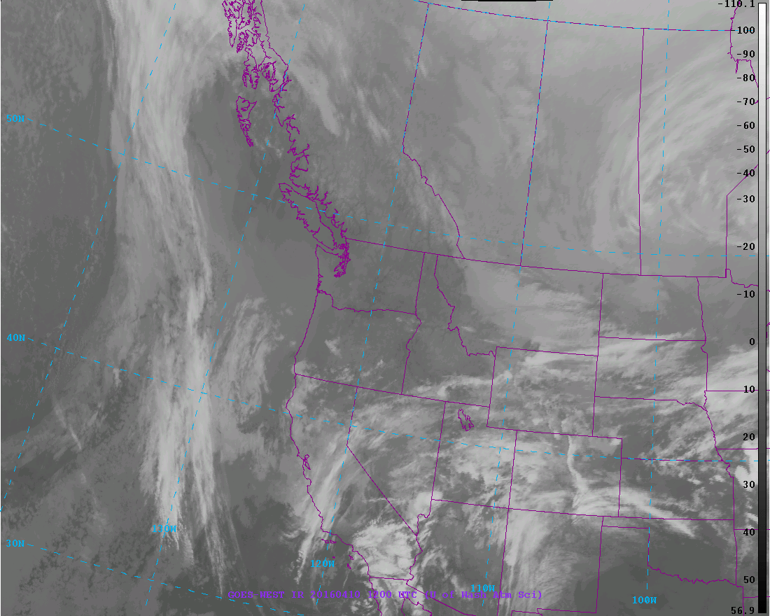
Then there is infrared satellite imagery, which is what you generally see on TV. Infrared imagery is based on the temperature of the clouds and surface (they use the emission of infrared radiation, which depends on temperature). In an infrared image, cold (generally high) features are shown by light colors, warm (generally low) by dark colors.
Here is the infrared image at 5 AM. You really can't see any low clouds over us. This makes sense, because low clouds are...low.... and thus their temperatures are very similar to the surrounding ground (dark or warm). So they are nearly invisible in the infrared.
But wily satellite meteorologists have found a way to deal with this problem: fog imagery! The National Weather Service geostationary satellites have imagers that observe the planet in a five wavelengths. One is visible and two are classic infrared. There is a water vapor channel for observing the distribution of water vapor in the atmosphere, and a short wave infrared channel, with an intermediate wavelength (around 4 microns, millionths of a meter for you tech-oriented folks).
It turns out that by looking at the difference in emission between the infrared and short wave infrared channels one can determine the location of fog and low clouds. More specifically, there is a significant difference in the emission of infrared radiation by water droplets between the infrared and short-wave infrared wavelengths; thus, the difference can be used to determine where water clouds are found (and low clouds are inevitably water clouds in most areas).
Let me show you the fog imagery at 5 AM this morning. Can you see that whiter shading over western WA and Oregon as well as the eastern Pacific. That is fog and low clouds.
Better get used to clouds. These week will be cooler with occasional showers. I will regretfully be putting my summer clothes away for a while.
The European social model is a common vision many European states have for a society that combines economic growth with high living standards and good ...
Sunday, April 10, 2016
Friday, April 8, 2016
Thursday High Temperatures and Today's Situation
The high temperatures yesterday ranged from near 90F in favored areas (away from marine influence, at the bottom of west-facing slopes) to fifties near the water. Here is a map of the highs on Thursday. Amazing contrasts. Mid to upper 80s southwest of the Olympics and similar temperatures on the western slopes of the Cascades east of Seattle. But 58F at the buoy positioned in the eastern side of the Strait of Juan de Fuca. 90F north of Portland.
What about today? An interesting situation.
The temperatures aloft, say at 5000 ft, are nearly identical to those of yesterday. But the offshore (easterly) flow is weaker. The north-south pressure difference is also weaker, so the cooling northerly flow that moderated Seattle yesterday will decline today. The figure below shows the temperatures and winds above Sea Tac for the past 24h. At 850 hPa (about 5000 ft) the temperature line (red) is almost horizontal. No change. But the strong low-level easterlies are gone.
So in this situation, one might expect that the eastern suburbs of Seattle will cool a bit (say to around 80F), while Seattle and the lower elevations will be similar or cool slightly.
Another summer-like day. Enjoy.
In the Seattle area, there were 60s near the water but low 80s over northeast Seattle away from the water. Mid 80s over the eastern suburbs.
What about today? An interesting situation.
The temperatures aloft, say at 5000 ft, are nearly identical to those of yesterday. But the offshore (easterly) flow is weaker. The north-south pressure difference is also weaker, so the cooling northerly flow that moderated Seattle yesterday will decline today. The figure below shows the temperatures and winds above Sea Tac for the past 24h. At 850 hPa (about 5000 ft) the temperature line (red) is almost horizontal. No change. But the strong low-level easterlies are gone.
So in this situation, one might expect that the eastern suburbs of Seattle will cool a bit (say to around 80F), while Seattle and the lower elevations will be similar or cool slightly.
Another summer-like day. Enjoy.
Thursday, April 7, 2016
Crazy Warm
Once in a while, I see something that is truly amazing. It's happened today. Here is a plot of the climatology of temperatures at the Quillayute, Washington radiosonde site, specifically, the temperature at 850 hPa, around 5000 ft. Today's temperature is shown by the silver dot. The red line shows the daily records, the black line is the average. The temperature observed today (16.5C) is the warmest ever observed for ANY DATE between January 1 and April 24th.
So the air over us is amazingly warm. And to add to it, the flow aloft is now easterly and thus offshore, which isolates us from the marine influence and produces downslope warming. Here is a plot of the temperatures and winds above Seattle-Tacoma Airport for the past 24 h. (time in UTC on x axis, pressure on y axis, 700 is about 10,000 ft). At 850 hPa, the temperatures have warmed from 4 to 18C, a 14C (25F) jump. Extraordinary.
It is going to burn today. UW Probcast (www.probcast.com) is going for 85F in Seattle. What could modify this warmth is if cooler northerly flow modifies the temperatures at lower elevations...which is possible if the easterly flow is not strong enough. Then we would end up in the upper 70s. Current models tend to mix air in the vertical too much, so they tend to overpredict temperatures in this situation.
So far, temperatures are moderate at low levels because the warm air is above us (see plot), but when that air mixes down, expect temperatures to rocket up. I am looking for my shorts.
So the air over us is amazingly warm. And to add to it, the flow aloft is now easterly and thus offshore, which isolates us from the marine influence and produces downslope warming. Here is a plot of the temperatures and winds above Seattle-Tacoma Airport for the past 24 h. (time in UTC on x axis, pressure on y axis, 700 is about 10,000 ft). At 850 hPa, the temperatures have warmed from 4 to 18C, a 14C (25F) jump. Extraordinary.
It is going to burn today. UW Probcast (www.probcast.com) is going for 85F in Seattle. What could modify this warmth is if cooler northerly flow modifies the temperatures at lower elevations...which is possible if the easterly flow is not strong enough. Then we would end up in the upper 70s. Current models tend to mix air in the vertical too much, so they tend to overpredict temperatures in this situation.
So far, temperatures are moderate at low levels because the warm air is above us (see plot), but when that air mixes down, expect temperatures to rocket up. I am looking for my shorts.
Wednesday, April 6, 2016
Heat Storm Hits the Northwest
You heard of heat waves, an extended period of much above normal temperatures.
But tomorrow we will have something else, what I will call a HEAT STORM, a short pulse of torrid temperatures.
The average high right now at Seattle Tacoma Airport is 57F. Tomorrow might well get into the lower 80s...and perhaps higher. Roughly 25F above normal, with daily records falling all over the place.
But there is a range of forecasts--let's look at them.
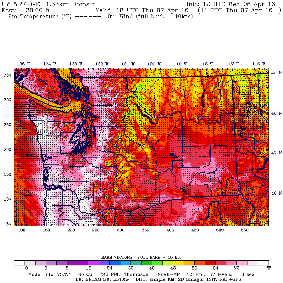
The UW highest resolution forecast model--the raw prediction--is very warm.
At 8 AM tomorrow (Thursday). The warmest temperatures are on the western slopes of the Cascades and coastal mountains, consistent with easterly (offshore) flow.
By 11 AM, temperatures in those areas are ABOVE 80F (white)
Much above 80F temperatures are widespread over western WA at 5 PM.
We can plot the temperatures and winds at Seattle Tacoma Airport produced by the model,which is called meteogram, with time in UTC (GMT).
Unbelievably warm, withtemperatures surge to around 90F! The winds show this heat storm is associated with a pulse of easterly flow.
Possibly the best predictor of local temperatures in such situations is probcast (www.probcast.com), a UW project that does sophisticated statistical post-processing of an ensemble of many local weather forecasts. It is going for 84F.
The Weather Channel has excellent forecasts, but does not have the advantage of the uber-high resolution predictions available locally. There forecast is more conservative (79F):
The National Weather Service? 82F
How about the National Weather Service short-range ensemble (SREF)? Lots of higher resolution forecasts (see below). Looks like roughly 81F.
The bottom line is that many locations will see temperatures climbing into the low 80s tomorrow...which is really quite extraordinary for early April. We should surpass some daily records.
The cause of all this warmth? A high amplitude ridge or area of high pressure over the West Coast (see upper level map at 5 AM Thursday).
This configuration brings in warm air aloft, as well as low-level easterly flow with reduces cool marine influences and forces downslope warming.
As I have discussed several times, there is no reason to expect that this ridge or high pressure has anything to do with global warming, or that anthropogenic (human-caused) warming will cause more ridges like this. In fact, climate models suggest just the opposite: increasing greenhouse gases will lessen the amplitude of such waves. Perhaps global warming is contributing 1-2F of a temperature anomaly of 20-30F.
But tomorrow we will have something else, what I will call a HEAT STORM, a short pulse of torrid temperatures.
The average high right now at Seattle Tacoma Airport is 57F. Tomorrow might well get into the lower 80s...and perhaps higher. Roughly 25F above normal, with daily records falling all over the place.
But there is a range of forecasts--let's look at them.
The UW highest resolution forecast model--the raw prediction--is very warm.
At 8 AM tomorrow (Thursday). The warmest temperatures are on the western slopes of the Cascades and coastal mountains, consistent with easterly (offshore) flow.
By 11 AM, temperatures in those areas are ABOVE 80F (white)
Much above 80F temperatures are widespread over western WA at 5 PM.
We can plot the temperatures and winds at Seattle Tacoma Airport produced by the model,which is called meteogram, with time in UTC (GMT).
Unbelievably warm, withtemperatures surge to around 90F! The winds show this heat storm is associated with a pulse of easterly flow.
Possibly the best predictor of local temperatures in such situations is probcast (www.probcast.com), a UW project that does sophisticated statistical post-processing of an ensemble of many local weather forecasts. It is going for 84F.
The Weather Channel has excellent forecasts, but does not have the advantage of the uber-high resolution predictions available locally. There forecast is more conservative (79F):
The National Weather Service? 82F
How about the National Weather Service short-range ensemble (SREF)? Lots of higher resolution forecasts (see below). Looks like roughly 81F.
The bottom line is that many locations will see temperatures climbing into the low 80s tomorrow...which is really quite extraordinary for early April. We should surpass some daily records.
The cause of all this warmth? A high amplitude ridge or area of high pressure over the West Coast (see upper level map at 5 AM Thursday).
This configuration brings in warm air aloft, as well as low-level easterly flow with reduces cool marine influences and forces downslope warming.
As I have discussed several times, there is no reason to expect that this ridge or high pressure has anything to do with global warming, or that anthropogenic (human-caused) warming will cause more ridges like this. In fact, climate models suggest just the opposite: increasing greenhouse gases will lessen the amplitude of such waves. Perhaps global warming is contributing 1-2F of a temperature anomaly of 20-30F.
Tuesday, April 5, 2016
Ethnic Queen Magazine Ethnic Model Casting Calls 2017 Model Search
Ethnic Queen Magazine Official International Model Casting Calls 2017 For Female Ethnic Models, Female Indian Models, Female Asian Models, Female Latina Models, Female African Models, Female Native American Models, Female Mixed Race Models, Female African American Models, Female Desi Models, Female Middle Eastern Models, and Female East Indian Models ages 18-35 that are proud of their ethnic beauty and culture.
Ethnic Queen Magazine is published by the International Beauty Movement who also publishes the internationally known and very popular Ripping Runways Magazine, Girl 9 Bikini Magazine, Project Couture Magazine, and Salon Savvy Magazine.
Ethnic Queen Magazine is the newest magazine to the International Beauty Movement publishing family that over 200 models worldwide are submitting their photo portfolios to be a possible feature model in this very new and popular magazine..
Ethnic Beauty Magazine is an online magazine that celebrates the amazing beauty of ethnic women, the vibrant culture, and the unique diversity that beautiful aspiring ethnic models worldwide bring to the fashion, beauty, and entertainment industry.
If you are a beautiful aspiring ethnic model age 18-35 that is interested in an incredible print modeling opportunity that could take your modeling career to the next level and open up modeling opportunities in the professional print modeling industry, commercial modeling industry and entertainment industry, as well as help you build an impressive modeling portfolio that could increase your modeling job opportunities, and gain worldwide exposure as a print model or commercial model, then you will want to respond to this International Magazine Casting Call For “Ethnic Queen Magazine” if you are a beautiful aspiring Female Indian Model, Female Asian Model, Female Latina Model, Female African Model, Female Native American Model, Female Mixed Race Model, Female African American Model, Female Desi Model, Female Middle Eastern Model, or a Female East Indian Model.
We are giving you the amazing opportunity to be a possible feature model in the next issue of Ethnic Queen Magazine, which could be the high profile modeling opportunity that takes your aspiring modeling career to the next level and opens doors to so many great paying jobs and opportunities in the fashion and entertainment industry.
Are you ready to take your aspiring modeling career to the next level as an ethnic model?
To apply for consideration as a feature ethnic model For Ethnic Queen Magazine, you will need to submit a professionally written bio with your age, your city, state, or country, your height, weight, measurements, your email address, and phone number and 12 -20 recent professional full body high resolution photos in formal dress clothing or your native country clothing, casual clothing, and lingerie or bikini, pleasesubmit no less than 12-20 of your most recent and most impressive full body professional high resolution photos (that are no older than 12 months) with no writing on them, no logos, or photographer watermarks or signatures.
Submit 12 -20 recent full body professional photos of you posing and bio with complete contact information and measurements to: internationalbeautymovement@aol.com
THESE PHOTO SUBMISSION GUIDELINES APPLY
International Beauty Movement Web Site:
PLEASE CLICK LINKS BELOW TO VIEW OUR MAGAZINES ONLINE:
Please Click One Of the Links Below To Read Ethnic Queen Magazine: http://internationalbeaut.wix.com/internationalbeauty#!online-magazine
http://issuu.com/rippingrunways/docs/2016_ethnic_queen_magazine_debut_is?e=6108760/37587277
Please visit our casting call link to view all of our current casting calls for aspiring female models worldwide at: http://rippingrunways.blogspot.com/
TO THE ABOVE CASTING CALL.
We do not accept photos that are older than 12 months, we do not accept camera phone photos, we do not accept photos with more than one model in it, we do not accept photos posted on other websites, we do not accept low resolution photos, we do not accept photos with writing on them, logos, or photographer signatures, and we do not accept personal photos that are taken in your home, we do not accept photos that are collages or have effects, or have borders added to them, so please do not submit none of the above or your photos will not be considered as a possible feature in Ripping Runways Magazine.
Please Feel Free To Visit Our Websites
and Read Our Magazines At The Links Below:
International Beauty Movement Web Site:
Click Link Below To Become A Member of the International Beauty Movement:
Please Click One Of the Links Below To Read Ethnic Queen Magazine: http://internationalbeaut.wix.com/internationalbeauty#!online-magazine
http://issuu.com/rippingrunways/docs/2016_ethnic_queen_magazine_debut_is?e=6108760/37587277
Please visit our casting call link to view all of our current casting calls for aspiring female models worldwide at: http://rippingrunways.blogspot.com/
Monday, April 4, 2016
60F at one's head and 32F at one's toes
Yesterday, I skied up to Stampede Pass with a group of weather-oriented folks to visit the repaired National Weather Service observing site. It was amazingly warm, with yesterdays air temperature at that location reaching 61F between 3 and 4 PM (see plot). At the same time, the snow was melting at the surface, so we know the temperature of the snow surface: 32F. So roughly a 30F difference between my head and toes!
But the contrasts don't end there. The temperature dropped to the mid-30s by 3 AM today--12 hours later. And that was accompanied by snow! So sunny and hot to cold/windy/snow a few hours later....you got to love our weather here.
Here is the National Weather Service ASOS observing site, high on a platform above the snow.
On the right, a precipitation type identifier, a temperature/humidity sensor, and a visibility sensor.
Stampede Pass is the home of many power line swaths, which afford some wonderful views, although the snap, crackle, and pops of the power lines can be disconcerting.
The sky yesterday was full of high cirrus/cirrostratus associated with an approaching front. But there were also many lenticular (lens-shaped) mountain wave clouds. Here is a sample.
Lenticular clouds often form downstream of our mountains when a weather system approaches. First, the approaching system is associated with increasing relative humidity, so that the additional lift forced by the mountains produces clouds. Second, wind perpendicular to the mountains increasse, which is good for business of the waves produced by the mountains.
We were very fortunate to be accompanied by Randy Cryer, a long-term observer (and resident) at Stampede Pass, who told us about the history, geology, and meteorology of the pass, and particularly the large impact of the early trains. I told him that he should write a book about Stampede Pass.
Virgil G. Bogue discovered the pass on March 19, 1881. The northern Pacific railroad would go through the pass, and as work on the project proceeded, Mr. Bogue sent out a new foreman to speed-up the work. The men had enough and quit. The response: "No work, no eat," and the men stampeded for the valley and therein came the name.
While we were at the pass we noticed a number of general aviation aircraft flying across the area. Randy told us that the weather station was established in 1943, when several aircraft crashed as they crossed the Cascades. Some of you may remember that when the weather station was closed for a year in 1990, several planes crashed with some fatalities. It is good that the weather station, with its excellent observing equipment, is back online.
But the contrasts don't end there. The temperature dropped to the mid-30s by 3 AM today--12 hours later. And that was accompanied by snow! So sunny and hot to cold/windy/snow a few hours later....you got to love our weather here.
Here is the National Weather Service ASOS observing site, high on a platform above the snow.
On the left is a rain gauge, a freezing rain sensor, and a laser ceilometer.
On the right, a precipitation type identifier, a temperature/humidity sensor, and a visibility sensor.
Stampede Pass is the home of many power line swaths, which afford some wonderful views, although the snap, crackle, and pops of the power lines can be disconcerting.
The sky yesterday was full of high cirrus/cirrostratus associated with an approaching front. But there were also many lenticular (lens-shaped) mountain wave clouds. Here is a sample.
Lenticular clouds often form downstream of our mountains when a weather system approaches. First, the approaching system is associated with increasing relative humidity, so that the additional lift forced by the mountains produces clouds. Second, wind perpendicular to the mountains increasse, which is good for business of the waves produced by the mountains.
We were very fortunate to be accompanied by Randy Cryer, a long-term observer (and resident) at Stampede Pass, who told us about the history, geology, and meteorology of the pass, and particularly the large impact of the early trains. I told him that he should write a book about Stampede Pass.
Virgil G. Bogue discovered the pass on March 19, 1881. The northern Pacific railroad would go through the pass, and as work on the project proceeded, Mr. Bogue sent out a new foreman to speed-up the work. The men had enough and quit. The response: "No work, no eat," and the men stampeded for the valley and therein came the name.
While we were at the pass we noticed a number of general aviation aircraft flying across the area. Randy told us that the weather station was established in 1943, when several aircraft crashed as they crossed the Cascades. Some of you may remember that when the weather station was closed for a year in 1990, several planes crashed with some fatalities. It is good that the weather station, with its excellent observing equipment, is back online.
Saturday, April 2, 2016
Taste of Summer in Early Spring
The last few days have been the warmest since October, with Seattle Tacoma Airport reaching 70F twice (see image below). We are talking about being 15F above normal!
Let's compare this to the same 4 week period last year. Generally similar, although last year had more days above normal.
And during the last few days we have been seeing the classic summertime low clouds on the coast, with a minor marine push this morning. Enough to bring some light drizzle to the early visitors to the new 520 bridge. Friday morning was the first try for the marine air, as shown by the image at 9:30 AM, with tendrils through the Strait and the Chehalis Gap south of the Olympics.
By 2 PM, the shallow low clouds had retreated to the the coast. Still plenty of snow in the mountains.
At 2:30 PM most of the low clouds had burned off, with a remnant left to the NE of the Olympics. No wonder folks on the 520 bridge got a sunburn.
The dry conditions will end tomorrow night as a modest front moves to the coast during the late afternoon and into the interior around midnight (see forecast precipitation for the three hours ending 8 PM).
But don't be too depressed. ANOTHER strong ridge will develop midweek with more temperatures near 70F.
Let's compare this to the same 4 week period last year. Generally similar, although last year had more days above normal.
And during the last few days we have been seeing the classic summertime low clouds on the coast, with a minor marine push this morning. Enough to bring some light drizzle to the early visitors to the new 520 bridge. Friday morning was the first try for the marine air, as shown by the image at 9:30 AM, with tendrils through the Strait and the Chehalis Gap south of the Olympics.
By 2 PM, the shallow low clouds had retreated to the the coast. Still plenty of snow in the mountains.
Last night and this morning, an upper level trough moved towards the coast (see 500 hPa, roughly 18,000 ft at 11 PM Friday).
This weak trough, and its associate upward motion, deepened the low level marine layer and enhanced the onshore pressure gradient. The result: more persistent clouds and some very light drizzle. Here is the visible satellite picture at 9:15 AM Saturday--Puget Sound was covered.
The dry conditions will end tomorrow night as a modest front moves to the coast during the late afternoon and into the interior around midnight (see forecast precipitation for the three hours ending 8 PM).
But don't be too depressed. ANOTHER strong ridge will develop midweek with more temperatures near 70F.
Subscribe to:
Posts (Atom)
Popular Posts
-
Superstorm Sandy struck the NY metropolitan area during the last week of October 2012, result in 233 deaths and 75 billion dollars in damage...
-
An atmospheric river, a warm current of large amounts of water vapor, will be approaching our region starting later tomorrow (Tuesday), but ...
-
An extreme weather or seasonal climate event occurs and one question is often asked: to what degree was human-forced global warming the ca...
-
During the past several days I have enjoyed a wonderful treat, as folks around western Washington have sent me some spectacular cloud photos...
-
Mother nature must be watching her seasonal clock very carefully, because as we officially transition to fall today, a major storm has moved...
-
For Northwest snow lovers, this is turning out to be a good year, with FAR more snow than during the snow-drought winter of 2014-2015. Let...