Thursday, May 19, 2016

Cherry Weather Worries

Eastern Washington State is one of the premier growing regions for sweet cherries in the world, possessing both good soils and climate.  But cherries have weather vulnerabilities that can cause severe loss of fruit.    One of them is frost during the budding season, but that has not been much of a problem during the past few years due to our unusually warm weather.


But there is another: rain just before harvest that can cause fruit to split.  Recently, unusually heavy rain hit California, halving their harvest.  Very bad.


Typically, the Washington State cherry harvest starts around June 1st.   But with unusually warm weather, the date will probably move up to May 23rd, according to what I have been reading in the Ag magazines.  Very soon.  


The problem is that with a trough of low pressure moving over us, significant rain is forecast during the next several days (see the WRF model 24h total ending 5 PM Saturday)... .5-1 inches over some of the cherry growing region over the eastern slopes of the Cascades.  Heavier amounts in some location.  This is very good for general moisture over eastern WA and  to keep the fire threat down.


According to the agricultural experts at WSU,  when cherries are close to harvest the pressure inside increases.  Rain, particularly when the weather is warm, can be absorbed through the outer surface of the cherry (called the cuticle),  sometimes leading to the bursting of the cherry.  Heavy thunderstorms during warm weather are particularly problematic.  Burst cherries may not look great, but are certainly valuable for many uses (juice, jam, etc.).  They are less valuable.


Growers have a number of approaches to deal with rain on cherries, including blowers and running helicopters over orchards.


The main rain threat is on Friday/Saturday as the upper low passes south of Washington and precipitation swings northward over eastern Washington, accompanied by easterly (upslope flow)--see upper level (500 hPa) map for Friday at 11 PM.

 Since we are very early in the cherry season, only a limited amount of the crop is vulnerable.   But orchardists and meteorologists will be watching the situation closely.   I certainly will--I love cherries and limited supply can cause the price to rise.

Tuesday, May 17, 2016

Troughzilla

Well, we had Ridgezilla, the intense area of high pressure that brought low snowpack and warm temperatures last year.  Or the persistent and powerful Godzilla El Nino.  But during the next week we will experience something different:  Troughzilla, an area of intense low pressure over the west coast that will make it cooler and wetter than normal at least through next week.


Let me show some upper level  (500 hPa, around 18,000 ft) forecast maps that document the  development of this beast.   Today was a fine day, with a modest ridge over us (see map for 5 PM today-Tuesday).   This is the last day of warmth for a while.

 By 5 PM Wednesday, a trough of low heights (or pressures) has developed over the eastern Gulf of Alaska.
 One day later (Thursday 5 PM), a very strong low center is centered over western Washington and a huge, powerful ridge over the central NE Pacific.

Friday afternoon?  Now it has grown and extended into California.


 On Saturday at 5 PM, the infernal beast is now over the entire West Coast.

As you can imagine, this pattern is not going to result in any heat waves, as illustrated by the latest forecast for Seattle from the Weather Channel. No more 70s or 80s for a while.   Temperatures at or even below normal.

Precipitation?   You bet.   For the next 72 hours, wet offshore and modest rain over our local terrain.


 The next 72 h (ending 5 AM Monday) is far wetter, with several inches over the mountains, lots of moisture over eastern Washington, and substantial rains over northern CA.

The atmosphere has shifted to a very different configuration, one we have not seen for a while.  Find a sweater and protect you tomatoes.

Sunday, May 15, 2016

Heavy Rain and Potential Flooding (And a Warning about Parking)

I knew it was dangerous to do a blog on arid conditions on Friday the 13th.

Yesterday, a low pressure center to our southeast rotated moist, easterly flow into our region with substantial upslope precipitation leading to National Weather Service flood watches along the eastern slopes of the southern WA Cascades and over the Blue Mountains of NW Oregon (see figure below).

Here are the 24 h precipitation totals for southern WA.  Some locations near the Cascade crest received more than an inch, with many locations along the eastern slopes wetted by a half-inch.


With the system centered to the south, Oregon got even more rain, with some locations in the coastal mountains getting more than an inch.

Eastern slope rivers are surging from the combination of rainfall and snowmelt.  The critical Yakima river reservoirs are near capacity and still rising (blue line below).  Yakima agriculture should have plenty of water this summer.


As noted earlier, the cause of this wet bounty on the Cascade eastern slopes and Oregon has been a  low center positioned ever southern Idaho.  The 850 hPa (5000 ft) map below shows this feature clearly (wind barbs and temperatures at the level are also shown).


The slow-moving low will continue precipitation over eastern WA and Oregon for the next 24-h, as shown by the latest WRF model forecast below.  Go north, if you want drier weather.


This week is going to be interesting.   First, a weak ridge will develop over us, providing temporary improvement.  But then  a HUGEridge develops over the Pacific and a very deep low forms over our region (see upper level map for Friday at 8 AM).  WOW.


This a cool, wet pattern for us.  To show this, here is the 72h precipitation total ending 5AM Saturday.   Even California gets a piece of this.   You can expect the wildfire danger to be greatly reduced and all current fires should be controlled.   

One negative about rain--it is not good for maturing cherry crops.  California's harvest was radically reduced by recent, unseasonable rain.  I hope the same doesn't happen with WA cherries, which I love.
__________________________________________
Public Service Announcement: WARNING TO HIKERS ON CHUCKANUT DRIVE south of Bellingham.

If you are hiking near the trailhead of the wonderful Oyster Dome hike on Chuckanut Drive (SR 11), be VERY careful.  The State Patrol and their towing company buddies are towing lots of cars.  So be very careful if you park there.


Friday, May 13, 2016

Arid Spring

I have been doing a lot of gardening the past week, and I am startled by how dry the soil is.


What is particularly surprising is the aridity of the soil following the wettest winter in Northwest history.  The lack of rain was accompanied by very warm temperatures (April was the warmest on record at several western WA location, which has led to an earlier start of the fire season, with several wildfires west of the Cascades.  The picture below shows a fire in Snohomish County.


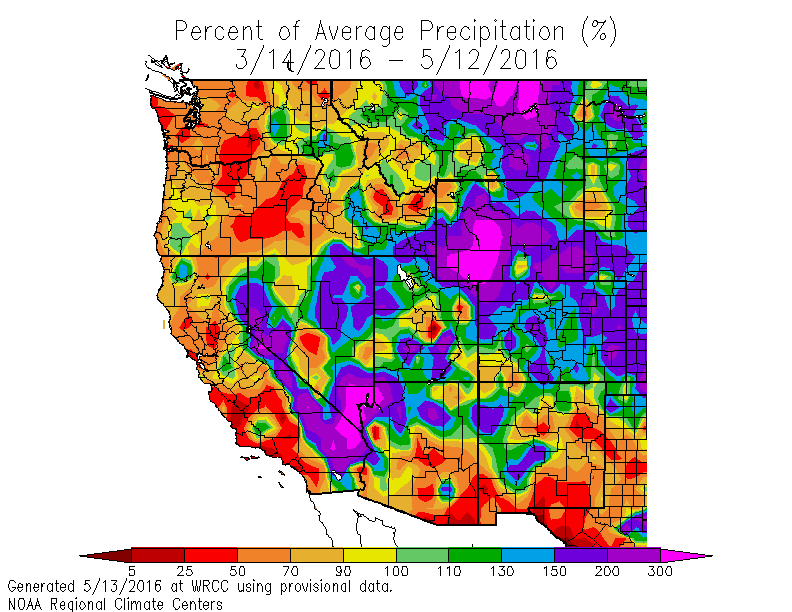
So what happened?  Let's start by looking at the percentage of normal precipitation for the past two weeks (below). Western WA and Oregon are very dry, with some locations at less than 5% of normal.

But percentages can be deceiving--here is the departure of observed precipitation from normal for the same period.  Less scary....but you will notice that some areas of western Washington are down a bit over two inches.  Much better situation east of the Cascades and over California/Nevada.

What about the entire spring?  Here are similar figures for the last 60 days.   For the percent of normal precipitation, much of the Northwest is well below normal--some locations 25-50% of normal.

Departure of accumulated precipitation?  2-6 inches in western Washington, 0-2 inches in eastern WA.  

So why have we been so dry and warm here in western Washington?   The key cause is persistent high pressure (ridging ) aloft.    Here is the difference from normal (anomaly) over the past 30 days for upper level  (500 hPa) heights (like pressure).  Above normal heights (yellow colors) over SW Canada and the northern portions of the Northwest).    Such ridging brings sinking air and dry/warm conditions.


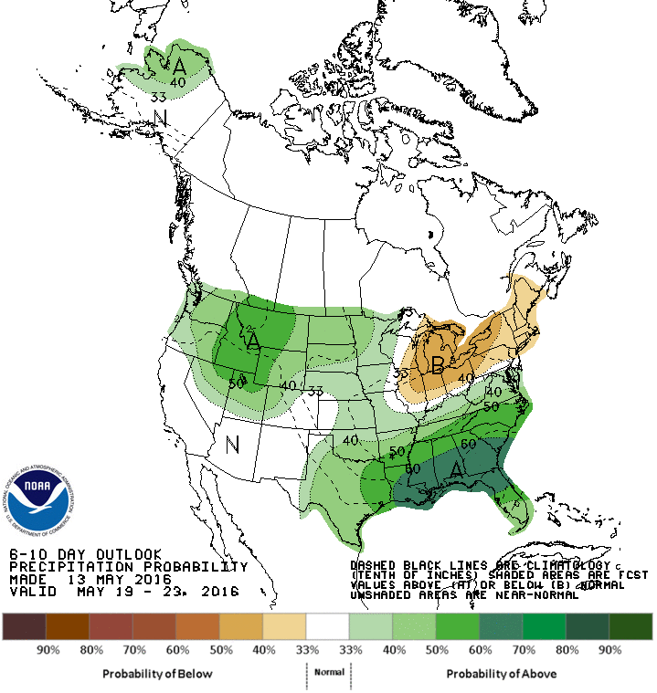
This persistent pattern is rapidly evolving and next week an area of low pressure will move towards our coast.  The result will be clouds and rain.     Take a look at the latest 6-10 day precipitation forecast by the Climate Prediction Center.  Above normal precipitation over our region.  I suspect this will end the fire threat for a while.
______________________

KPLU Event!

Meet an astronaut (and me) tomorrow (Saturday, May 14) at the Museum of Flight for a KPLU fundraiser (music at 6 PM) and presentation (7PM).  Information here:

Wednesday, May 11, 2016

Major Cooling Ahead

We have all gotten used to the warm, sunny weather, which followed the warmest April on record for many Northwest cities.

But it is all going to end this weekend, with cool, showery weather settling in for an extended period.  

Real meteorologists prefer to look at the output of ensemble forecast systems that present the results of many predictions.  Here is the graphic from the North American Ensemble Forecasting System.   Warming through Friday...and then bang... an extended cool off, with increased chances of precipitation and clouds (the yellow boxes show the range of the middle 50% of the ensembles, the "whiskers" indicating the range of the predictions.


The latest 6-10 day predictions of the National Weather Service Climate Prediction Center?  Cool and wet over the region.


The precipitation total for the 72h ending 5 PM on Tuesday?  Wet!

Why the change?   The high pressure area over the West Coast is going to ridge heaven.  For example, at 5 PM Saturday, an area of low pressure is over us, with the ridge pushed inland (at 500 hPa, about 18,000 ft).  Cool.

 But look at Wed. at 11 AM!  Wow.  A strong low off of our coast, with moist southwesterly flow invading the Northwest.

So if you want to enjoy a sun-bathed walk in the park, do it during the next few days.   Thinking about planting some grass or a plant in your garden.  Do it NOW!  You won't have to water much.

Monday, May 9, 2016

Cooler West, Windy East

During the last day, winds have surged to amazingly levels in eastern Washington with gusty easterly winds reaching  60 mph.   Strong enough that it blew down a power line and started the first significant fire of the season (now about 50 acres) near Entiat, Washington (near the Columbia River).
 Here are the max gusts for the 24h ending 7 PM Monday for a domain stretching from southern Puget Sound to Walla Qalla.   The red numbers are winds over 50 mph.


In the spring, the winds increase rapidly when cool, Pacific air floods western Washington and Oregon as it did on late Saturday night.     Cool air is denser than warm air and is associated with higher pressure.  With the Cascades blocking much of cooler air on the west side, a large pressure difference (or gradient) develops across the Cascades.  In addition, the flux of cool air is often forced by an upper trough, which results in pressure declines east of the Cascades as it passes through.

Let me illustrate the development of a large pressure gradient across the Cascades with the sea level pressure forecasts for 8 AM Sunday.   The shading shows low-level temperatures, with green temperatures being cooler and orange/red warmer.   You can see the contrast in air temperature across the Cascades.  The solid lines are isobars (lines of constant pressure).  You note a lot of lines (strong pressure gradient) across the Cascades.    Such large pressure gradients produce strong winds as air accelerates from high to low pressure, particularly within the lower areas of the central Cascades.

There is a weakness in the Cascades north of Mt. Rainier called the Stampede Gap, so some of the strongest winds are around Ellensburg.  There is a reason there are a lot of wind turbines around there.  

Modern numerical models run at high resolution can forecast the strong winds along the eastern slopes of the Cascades fairly well.   Here is the sustained wind speed prediction for 8 AM on Sunday from the UW high resolution WRF model.  You see the strong winds along the lower Cascade slopes?

And here is a blow-up from our uber-resolution (4/3 km grid spacing) WRF model forecasts for gusts at the same time.  The model had isolated locations reaching 60 knots--not bad.


This is the windy season on the eastern Cascade slopes--with cool marine air on the west side and the eastern side warming rapidly (producing low pressure).  Wind power season.
_____________________

Major news:  the proposed coal terminal near Cherry Point (near Bellingham) has been stopped by the US Army Corps of Engineers.   Their reason:  to honor the treaty rights of the Lummi tribe to use those waters.  This is a huge victory for those concerned about coal dust, traffic backups near rail crossings, and the climatic effects of sending huge amounts of coal to Asia.

Saturday, May 7, 2016

Vigorous Onshore Marine Push and Good News for Mothers

Tonight, the passage of a weak front is resulting in a strong inland surge of marine air.  What we call a northerly onshore push.

The visible satellite image at 7 PM Saturday shows a narrow, but weak, front moving into western Washington.  There is virtually no precipitation with this feature.  But it is strong enough to cause cool marine air to push inland, particularly in the Strait of Juan de Fuca, where it is REALLY blowing right now.


For example, take a look at the maximum hourly gusts at Smith Island, located over the eastern side of the Strait.  WOW...gusts to 47 knots (54 mph)!


The UW WRF model has been forecasting the marine surge--here is the predicted gusts for 8 PM Saturday.   Red area is strongest winds--50 knot gusts over the eastern Strait.


And now the good news for all mothers.  Sunday really won't be bad at all.  A few sprinklers in the AM at most--particularly over central Puget Sound (where a weak convergence zone will be).  Low clouds in the morning, but plenty of breaks in the afternoon, particularly away from the central Sound.  Highs around 63-65F.    Plenty good enough to enjoy a nice walk with Mom at some park to admire the flowers.  Mom's like that kind of thing.  Plus flowers, cards, and chocolates.

Popular Posts