A massive smoke cloud from the eastern Washington fires has now pushed over Puget Sound and the imagery is amazing. Let's start with this morning's visible satellite imagery (around 8 AM). Over land there is a large amount of smoke, with the edge of the smoke cloud reaching central Whidbey Island at this time. The winds aloft have reversed so smoke is blowing from the northeast, with eastern Washington engulfed in the Okanagan fires and the Wolverine fire smoke heading towards Puget Sound.
But the most amazing imagery is from the Space Needle cam around 6 AM...you can see the edge of the smoke plume moving west of Seattle. Two views are shown (west and north)
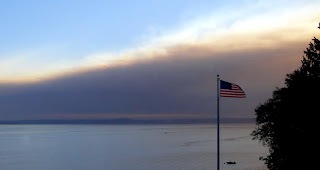
There is an extraordinary view of the smoke coming in from the wonderful skunk bay website, here are some samples. The cam is located on the northern Kitsap Peninsula, No clouds, just smoke.
The video from Skunk Bay is really impressive.
315" src="https://www.youtube.com/embed/VN6S78wKZYM" frameborder="0" allowfullscreen>
Skunk Bay Weather even has signature weather gear that helps support their site.
To show you the turn of the winds aloft to easterly, here are the winds and temperatures above Sea-Tac airport for the last day. If you can read the wind barbs, you will see easterly and northeasterly flow aloft (700 means 10,000 ft, 850 about 5000 ft). Time increases to the left and y axis is height.
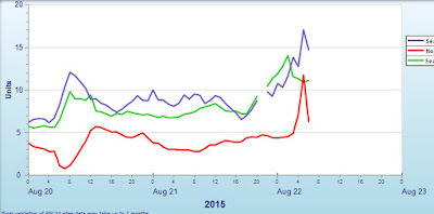
As a result of the smoke, the air quality has started to decline over Puget Sound at low levels: take a look at plots of the concentrations of small particles (less the 2.5 microns) at a few local measuring sites....not dangerous, but rising.
In contrast, air quality has been terrible in eastern Washington, with several locations getting to Beijing levels. Omak had gotten to 500 which is VERY,VERY high. But even Spokane got to 300. In contrast, Seattle has just reached around 15. When the concentrations get above 100 it can be dangerous for vulnerable populations.
We can use our weather forecast model output to create air trajectories, telling us where the air is going. Here is one starting over the Wolverine Fire at 7000 ft at 11 PM last night. Heading right for us! Confirmation of where our smoke is coming from.
Finally, expect today to be cooler than expected, the amount of solar radiation reaching the surface is much less than normal.
Smoke approach Coupeville (courtesy Randy Lundeen)


No comments:
Post a Comment