For the fires in the Olympics and the Cascades it should be the turning point.
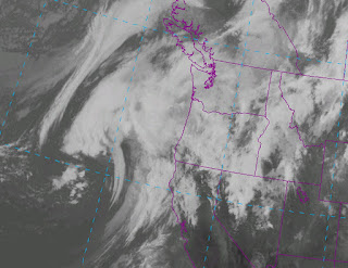
The satellite imagery Friday evening was impressive (see below). Lots of clouds, and a potent low center is developing in the swirl of clouds west of the northern CA.
Today was just a very slight taste of tomorrow. Here is the total rain as of 8 PM Friday. 3/4 inch in the Olympics and North Cascades. Only light rain over the Sound...that will change.
The models are forecasting a deep low pressure center (for this time of the year, for sure) to be poised to approach our coast a 5 AM tomorrow morning (see plot). This map shows the pressure and temperature pattern...with a very large pressure gradient south of the low.
The time shown is in UTC (GMT), so the peak winds will be between 11 AM and 2 PM. I was going to go fishing tomorrow with Greg Johnson of Skunk Bay fame, but put it off based on this forecast. The latest UW WRF model gust forecast for 11 AM Saturday is very windy, with crazy strong gusts along the coast and over northern Puget Sound. If you were thinking of going out there in a boat, think again.
With lots of growth over the summer and some branches weakened by drought, I suspect there will some power outages tomorrow. My friends at Seattle City Light are prepared...they will even have some extra crews ready to go!
Precipitation? Here is a plot of cumulative precipitation this weekend at Seattle for the various ensemble members. 1-1.5 inches at Seattle over the weekend is a good bet.
The 24h precipitation ending 5 PM is shown below: 1-2 inches in the Olympics and north Cascades....and this is not the end of it.
To be amazed, examine the 72hr rainfall totals starting 5 PM Friday--some locations in the N. Cascades and Olympics are predicted to get over 5 inches of rain! 2-5 over a lot territory. The Paradise fire is a goner...as are the fires around Nehalem.
Enjoy the weather...I certainly will.


No comments:
Post a Comment