The atmosphere has been shifting into a different configuration the past week, and during the next few days a major transition will occur, with persistent strong troughing (low pressure) over the Northwest. It will bring large amounts of rain to our mountains, knock back and end some of the fires, and allow firefighters to gain control of the situation for Cascade Mountain fires. It will bring substantial water to reservoirs that have dropped to extremely low levels.
Want to be impressed? Here is the forecast precipitation over the next 72h, 1-2 inches over that period for much of western Washington and the north Cascades.
The next 72h? As much or more over Washington's mountains. The BC Cascades get hammered with 2-5 inches.
Want to see a close-in view of WA precipitation for the 72h ending 5 AM Sunday? The north Cascades and western slopes of the Cascades get hit very hard. This will have a HUGE impact on the fires along the eastern slopes of the Cascades. Much of the Okanogan region will enjoy several tenths of an inch.
These storms should have a profoundly positive impact for the Cascade fires. There will be less rain over the Okanogan area and winds will pick up there (which is not good). On the other hand, temperature will fall and humidity will rise over NE Washington.
So what is going on? The persistent ridge that has given us warm temperatures and little precipitation has been shifting far out into the Pacific, leaving a series of troughs over the Pacific Northwest. To illustrate, let me show you the upper level (500-hPa) maps for several times for this weekend and next week.
Saturday morning: trough over the eastern Pacific and big ridge to the west.
Monday at 5 PM: same general pattern.
Wednesday afternoon, the trough has strengthened.
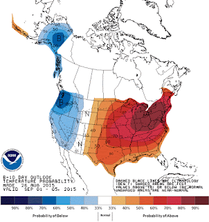
This change is not a one-day affair. That is why it is so important. It will end a chapter in this summer's fire season. The latest NWS Climate Prediction Center's 6-10 day forecasts? Much cooler than normal over the western U.S., with above-normal precipitation over the Northwest.
Fall is not here and eventually warmer conditions will return, but this will be the big break that many were waiting for--and expecting. The strengthening El Nino is disturbing the atmospheric circulation in a way that is weakening the crazy-persistent West Coast ridge. As I will explain in a future blog: Godzilla El Nino will kill the BLOB.
Finally, I should note that the requests for water conservation have had a big impact here in Seattle, as shown by the accompanying graphs, folks are using less water and the reservoir levels have stabilized. There will be some refilling during the next week.


No comments:
Post a Comment