As a result, the probabilities of of winds getting to 58 mph (shown below) are only high offshore. But even here in Washington State there will be some minor impacts (see below).
A visible satellite image from NASA MODIS satellite on Wednesday afternoon shows that Oho no longer possesses a distinct eye and does not have the symmetric look of a strong hurricane.
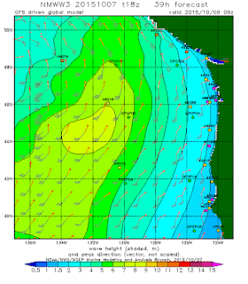
One impact from Oho will be waves that will propagate to our coast as long period swell. Here is a prediction from the NOAA Wavewatch III model for early Saturday morning. The yellows are 8 meter waves...around 25 ft. This swell will reach the WA coast on Saturday possibly causing beach erosion and dangerous breaking waves.
By tomorrow (Thursda) at 2 PM, the storm moves northeastward, roughly due west of the OR/CA border. The structure has changed, with the low turning into a trough and cooler air approaching the storm. Oho is undergoing what is called extratropical transition, transforming from a tropical to midlatitude storm.
Twelve hours late (2 AM Saturday), the storm had reach the waters of the central WA Coast. Cooler air is getting entrained into the system, which is looking very asymmetric--like most midlatitude cyclones. During extratropical transition the energy source of the storm changes, from the warmth of the ocean and the latent heat of water vapor, to the energy inherent in horizontal temperature contrasts.
A key reason why Hurricanes such as Oho undergo weakening and extratropical transition is that fact they pass over cooler water as they move northward. Generally, hurricanes need water of at least 27C to maintain themselves as a tropical storm. Take a look at the sea surface temperature distribution in the Pacific, with the route of Oho overlaid. Oho is now over far too cold water (08/1800 is 11 AM Thursday) to remain a tropical storm....in fact, it is now officially a POST-TROPICAL CYCLONE.
How strong might the winds get offshore? Here is the forecast for the surface wind gusts at 2 AM Saturday. Lots of gusts above 60 knots over north Vancouver Is and the offshore waters. It is good this storm is taking an offshore track!
Locally, it could get windy along the coast and over NW Washington, but nothing serious. If you were thinking of taking a Friday departure for an Alaska cruise, you might rethink your plans.
Carbon Tax Initiative: I 732
I-732 is now on the final stretch in getting signatures to put a revenue-neutral carbon tax in front of the state legislature. I strongly support the initiative and I hope you will as well. CarbonWashington need signatures and financial support. Places you can go to sign are found here.


No comments:
Post a Comment