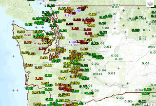
The rainfall totals for the 24-h ending 6 AM this morning (Sunday) were impressive (see regional and close in maps below). 1-1.5 inches over Puget Sound and 2-4 inches over the western slopes of the Olympics and the Cascades.
We can look at the storm-total precipitation graphics from the local weather radars. At the coastal Langley Hill radar, there is profound orographic (terrain ) enhancement with roughly .5 to 1 inch offshore and 1-3 inches over the southwest slope of the Olympics. As I have discussed before, the rising motions forced by terrain result in substantially increased precipitation on the windward slopes.
The Camano Is. radar shows similar enhancement over the western slopes of the Cascades where precipitation is greatly increased (as much as 3-4 inches)
Not surprisingly, this intense precipitation has caused western Cascade and Olympic Mt rivers to rise rapidly above normal levels, as illustrated by the Snoqualmie River at Carnation, WA:
Temperatures have been mild the last few days, with minimum temperatures about 5F above normal (see below). Dew points (a good measure of water in the atmosphere) were also unusually high, reaching the mid to upper 50s in many locations.
So why the intense rain and why have been so tropical lately?
The reason is a very large scale area of low pressure pressure that developed over the North Pacific just south of the Aleutians, with a ridge of high pressure over the Rockies. As shown by a forecast of the flow at 850 hPa (about 5000 ft ) for 5 PM Thursday (colors are temperatures, winds shown by wind barbs, heights (like pressure) shown by solid lines) this configuration produces strong southerly/southwesterly flow over the eastern Pacific, bringing warm and moist air northward over our region.
There are satellites that can measure the amount of water vapor from space and can clearly delineate the plumes of moisture from the tropics--also known as atmospheric rivers. Here is such moisture imagery for Friday and Saturday. You can see the conduits of moist, warm air into our region. Hawaiian air has come to you!
A weak front will come through tomorrow bring clouds and light rain, followed by a dry period into Saturday. Then rain returns. A very typical weather sequence for October.


No comments:
Post a Comment