There is a point in time each year that you can turn off your sprinklers, roll up the hoses, and enjoy the pleasure of natural irrigation and low water bills.
Today is that day. Admittedly, we are several weeks late with this, since mid to late September is more traditional for this important transition.
As you can see from the water usage graphic from Seattle Public Utilities, most folks have already gotten the message, with water consumption nearly down to winter levels.
The ground is moistening up now driven by cooler temperatures and the return of rain, although the temperatures have been slightly above normal west of the Cascade crest and precipitation drier than normal the last month.
But Saturday will bring some significant rain as a strong front moves through, enough rain to satisfy even the most finicky plants. Here is the forecast precipitation through Sunday at 5 AM. Pluvius looks favorably on us, with as much as 2-5 inches in the mountains and about a half inch over the lowlands.. This is the beginning of the reservoir refill period.
Only some places in the immediate rain shadow of the Cascades will not get rain. So if you want to stay dry, head for Vantage for a hike around the Columbia River and hit some wineries.
Looking at the 7 day totals from the NWS, the Northwest and BC have substantial totals. BC rain is good for us in Washington, because it provides water to the Columbia.
The latest seasonal model forecasts from the US Climate Forecast System (CFSv2) predicts wetter than normal conditions for November through January.
These results and other model predictions I am not showing suggest that we should have at least normal rainfall through the new year. This is good new for a number of reasons, including allowing water managers to build water storage of our reservoirs and for our ground water to recharge. Rivers should return to near normal levels. It also provides hope for a start of the ski season, particularly at higher elevation facilities.
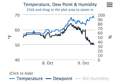
Finally, you may have noticed that temperatures have been relatively warm at night---mainly because of cloud cover and moist, subtropical air over the region. But there were spectacularly warm temperatures this (Friday) morning on hilltops east of Seattle. Peter Benda, whose home is at about 1000 ft in Bellevue, awoke to 68F this morning. He was not alone. Just to prove this to you, here is the temperature and dew point plot from his weather station for the period ending 7 AM. And
something else of interest...the dew points plummeted at the temperatures surged. A coincidence?
No way! The offshore passage of ex-hurricane Oho created an offshore pressure difference (lower offshore, higher inland), which produced easterly winds from eastern WA. As the air descended the western slopes of the Cascades they were compreseed and warmed. This warm air generally did not reach sea level, producing an inversion--temperature warming with height in the lower atmosphere---with temps near sea level in the 50s but near 70F a 1000 ft (see map with temps at 7AM)
Want to see the inversion? Here are the temperature plots last night over North Seattle from 2 AM to 8 AM. Temperatures increased by about 6C (11F) between sea level and 300 meters (about 1000 ft)
The European social model is a common vision many European states have for a society that combines economic growth with high living standards and good ...
Subscribe to:
Post Comments (Atom)


No comments:
Post a Comment