September is usually sunny and mild, with a few rainy periods that aren't too much of a nuisance.
Then, the first part of October brings cooling, but is often quite mild and not that wet.
But then something happens. The Northwest rain switch is flipped, and sometime in late October or early November we transition to our wettest, windiest weather.

The worst week of the year? Amazingly, the last week of November.
It is truly remarkable how quickly our region's weather degrades; almost like going off the proverbial weather cliff.
And folks, if the weather models are correct, it is going to happen in about a week.
But before I tell you about your sodden fate, let's look at climatology, in this case at Seattle Tacoma Airport. Here is the probability of getting .01 inch in a day. Very low during the summer, rising to about 40% in early October, but there there is the major ramp up to roughly 65% during the first week of November. From then on into March we are doomed to moisture almost every day.

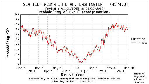
But that is light rain. What about the change of getting say, .5 inches, over a week? (see below) A huge ramp up between mid-October and the first week of November to about 75%. Ouch. And we stay up there for a while.
So, after softening you up with climatology, let me show you some precipitaton forecasts from the National Weather Service GFS model. During the next few days (through Sunday early AM), we will get virtually nothing, as shown by the cumulative rain during that period. So enjoy your Saturday!

But prepare yourself. Here is the forecast for the next 360 h (15 days). Orange is over 5 inches...and that is what is forecast over western Oregon and Washington. Even northern CA gets rain.

Now this is just one model and one forecast. What about the forecast from the many-model NAEFS North American ensemble system? (see below) The second panel is precipitation. The "whisker" shows you the range of precipitation amount for all the models and horizontal bar gives the median amount. Rain turns on around Oct 28th. The bottom panel shows cloud coverage greatly increases at the same and the panel above that is wind, which also increases. Rainy, windy, and cloudy. Sounds like typical Seattle winter weather.

So enjoy the last week of pleasant, mild, perfect fall weather. Take your last major hike on Saturday. The models don't think it will last, El Nino or not. During the next two week we should be making the transition to Northwest winter, first with light rain and then the heavier stuff in early November.
Our weather reckoning is coming. And the switch is about to be flipped.


No comments:
Post a Comment