During the last few days of heavy rain, our reservoirs have filled with enough water to supply the Puget Sound region's needs for the next three months or more. Furthermore, our mountain snowpack has gotten a good start for the season. And the next few weeks will bring a great deal of precipitation.
Water refill time is here.

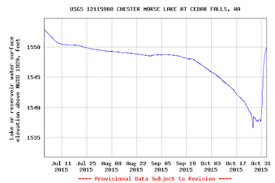
Let me begin by showing you two stunning figures: the water storage for Seattle's two reservoirs: Chester Morse and Tolt. At Chester Morse, the reservoir level has jumped nearly 13 feet, returning to the levels of late-July (more than 3 months ago, including periods of heavy water usage). This time of the year that much water could supply the region for an even longer period. Translation: the water worries of Puget Sound country this year are over.
The Tolt reservoir also had a big jump, back to the levels of mid-August.

Or we could look at one of the key reservoirs supplying water for the Yakima Basin, Keechelus, which is now approaching normal levels after being well below normal.

The impact of this major wet event was profound.
It is not always appreciated that although we have many days with precipitation during our winter season, most bring light rain that only add marginally to our water resources. The real business is done by roughly a half-dozen big wet storms, generally associated with atmospheric rivers. And this weekend, we had one of them.
Let me demonstrate this to you by looking at the cumulative precipitation over the best year at Seattle Tacoma Airport with the red line being the observed precipitation and the blue showing the average amounts. The last year had just below normal precipitation (not a precipitation drought). Note how the observed precipitation is staircased, with most of the precipitation occurring in 5-10 big events. This is very typical. Most of the refill of our reservoirs occur over roughly a half dozen events. Light rain events are not that productive, with a lot of the water evaporating from plants and the ground.
 Plenty more is coming. Here is the cumulative precipitation forecast through next Wednesday evening. Plenty of water over the Northwest. Even California gets some of the wet bounty.

Water refill time is here.
Let me begin by showing you two stunning figures: the water storage for Seattle's two reservoirs: Chester Morse and Tolt. At Chester Morse, the reservoir level has jumped nearly 13 feet, returning to the levels of late-July (more than 3 months ago, including periods of heavy water usage). This time of the year that much water could supply the region for an even longer period. Translation: the water worries of Puget Sound country this year are over.

The Tolt reservoir also had a big jump, back to the levels of mid-August.

Or we could look at one of the key reservoirs supplying water for the Yakima Basin, Keechelus, which is now approaching normal levels after being well below normal.

The impact of this major wet event was profound.
It is not always appreciated that although we have many days with precipitation during our winter season, most bring light rain that only add marginally to our water resources. The real business is done by roughly a half-dozen big wet storms, generally associated with atmospheric rivers. And this weekend, we had one of them.
Let me demonstrate this to you by looking at the cumulative precipitation over the best year at Seattle Tacoma Airport with the red line being the observed precipitation and the blue showing the average amounts. The last year had just below normal precipitation (not a precipitation drought). Note how the observed precipitation is staircased, with most of the precipitation occurring in 5-10 big events. This is very typical. Most of the refill of our reservoirs occur over roughly a half dozen events. Light rain events are not that productive, with a lot of the water evaporating from plants and the ground.


And now for something really amazing. You like snow in the mountains? Who doesn't? Here are the NOAA snowdepth plots for October 29 and November 1 (10 PM PST). We went from virtually nothing in the Cascades to several inches to roughly a foot in the higher elevations of the north Cascades,


The snow water equivalent of the snowpack (below) shows a similarly impressive change.


___________________________________
The Northwest Snow and Avalanche Workshop is this weekend (November 8th). Lots of great talks and a big crowd of snow lovers. For more information on the meeting and how you can attend, go here.


The snow water equivalent of the snowpack (below) shows a similarly impressive change.


Our region is now filling up from the water service station in the sky and it looks like the next few weeks will be typically wet.
The Northwest Snow and Avalanche Workshop is this weekend (November 8th). Lots of great talks and a big crowd of snow lovers. For more information on the meeting and how you can attend, go here.


No comments:
Post a Comment