THE NATIONAL WEATHER SERVICE IN SEATTLE HAS ISSUED A HIGH WIND
WARNING...WHICH IS IN EFFECT FROM 5 AM TO 6 PM PST TUESDAY. THE
HIGH WIND WATCH IS NO LONGER IN EFFECT.

* WIND...SOUTH OR SOUTHWEST 25 TO 40 MPH WITH GUSTS NEAR 60 MPH
  ARE POSSIBLE BEGINNING TUESDAY MORNING AND CONTINUING INTO THE
  AFTERNOON HOURS.
The forecasts for Northwest Washington are even stronger.
* WIND...WINDS MAY REACH 30 TO 45 MPH WITH GUSTS AS HIGH AS 65
  MPH ON TUESDAY.
I suspect that this event will cause some power outages but will not cause major damage. One reason for optimism is that we already have had lots of wind and the leaves are substantially off the trees now. On the other hand, the ground is saturated and that will foster the failure of tree root systems.
My latest examination of the model forecasts suggest that at the height of the storm, somewhere between 10 AM and 2 PM Tuesday, the winds will reach sustained values of 22-30 mph over land and 25-37 mph over water, with gusts reaching 30-50 mph over land and 50-65 mph over water.
Looking at the latest infrared satellite picture you would hardly think a windstorm is brewing, with no low center obvious off our coast.
8 PM Monday infrared satellite image
A modest low center will move into southern B.C. tomorrow (Tuesday) AM, while much higher pressure exists to its south (see image). The result is a large pressure differences north to south. Air tends to accelerate from high to low pressure near terrain and in this case it will produce strong southerly winds.
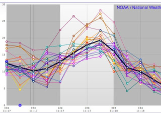
The updated NOAA SREF ensemble (many forecasts) is going for sustained winds of roughly 20 knots (23 mph) at Seattle Tacoma Airport.
Looking at the latest UW WRF sustained wind forecast near the height of the storm (noon) shows sustained 25 knots over Seattle, with stronger winds over the water. Increase by roughly 50% for max gusts. Much stronger winds along the coastal and near shore waters. And expect strong winds in the Strait and on volcanic peaks.
This is a major blow but NOT like the Chanukah Eve (2006) or Inauguration Day (1993) mega events.
And did I mentioned the rain? LOTS of it. Here is the rain prediction over the next 24h. 5-10 inches in the mountains, while locations to the east of the terrain will enjoy substantial rain shadowing.
There have been large snowfalls in the mountains above 4000 ft today and several ski areas are planning on opening this week (e.g., Baker, Whistler). With the passage of a warm front tonight, the freezing level will zoom upward and rain will fall on the some of that snow. But don't worry--the rain will only be around for roughly 12-18h and lots of snow is in the forecast this week. And believe it or not, it looks like a major break in the weather will occur this weekend and early next week.
I know what I will be doing...


No comments:
Post a Comment