Tuesday is going to be a particularly wild day. On Tuesday, the combination of a low passing through British Columbia and an approaching front will create a very large pressure difference across Washington State (see pressure forecast for 1 PM Tuesday below).
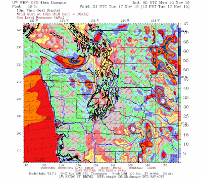
Such a large pressure gradient will produce powerful southerly winds, as illustrated by the forecast wind gusts over western WA shown below. Gusts will exceed 50 knots along the coast and in the Strait of Juan de Fuca. 30-50 kt gusts over Puget Sound country, with the higher winds over and near the water. Even higher winds at and immediately downstream of the higher Cascade peaks.
And heavy rain... On Tuesday a strong westerly atmospheric river will be making landfall on our area, as shown by the figure below at 7 AM that day (red colors indicate large moisture values).
Lots of moisture, plus strong winds, mean big precipitation totals in our mountains and the 48-h total ending 4 PM Tuesday will not disappoint: 5-10 inches in the Olympics and north Cascades.
And for those interested in our snowpack, here are two maps, one this morning and the other two days ago....a major increase in snow! And it is not over....


No comments:
Post a Comment