

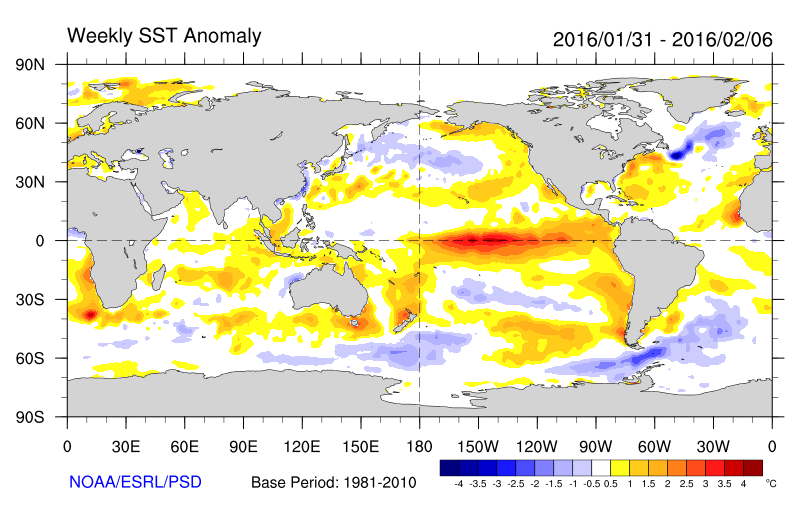
Want a map perspective? Here are the sea surface temperature anomalies (again, differences from normal) for the first week of February and June. Major changes in the tropical Pacific, where we went from a huge warming (red area near the equator) to cold water, surrounded by some slightly above normal water.

Another measure of El Ninos is the heat content of the upper 300 meter of the tropical Pacific. Warm El Ninos have above normal heat content. As the figure shows below, the heat content has one from well above normal to below normal--a sign of El Nino death and replacement by La Nina.

A recent forecast of Nino3.4 temperatures shows a rapid movement to an official La Nina (cool anomalies of at least .5C). (see graphic) I suspect we are crossing that threshold as you read this blog.

The warm sea surface temperatures in the tropical Pacific with El Nino has a profound impact on global atmospheric circulations. Thus, the collapse of El Nino would be expected to cause global circulations to change.
A key "teleconnection" of El Nino is a deep trough (low pressure) in the northern Pacific. This low pressure area is clearly evident in the flow pattern for April, shown by the two top panels below (which show the height (equivalent to pressure) in the mid-troposphere (500 hPa) . The blue area over the Pacific signifies the low pressure. Low pressure over the Pacific tends to cause higher pressure (ridging) over our region. But as El Nino weakened, the flow rapidly changed, with the Pacific low attenuating greatly During the lat panel (May 20-June 3), the Pacific trough was gone and the ridge had moved westward.

The latest forecasts suggest a trough of low pressure will develop and remain over our region this week.
The bottom line is that the strong forcing of El Nino is gone and the atmospheric is evolving quite differently this summer than last. So don't expect a repeat of last summer.
Announcement
My graduate student, Connor McNicholas has developed a wonderful weather app that collects pressures on Android smartphones and gives you all kinds of valuable weather information. We believe we can revolutionize weather prediction using dense collections of pressures from smartphones. We need folks to try this app (and it already has been evaluated by dozens of folks) to ensure it works well. If you are willing to help, you can get more information and download it here: https://www.cmetwx.com/
Thanks...cliff


No comments:
Post a Comment