The key transition is a profound change in the upper level flow pattern. For the past week, the circulation aloft has been dominated by a ridge of high pressure over the western U.S., something documented in the upper level (500 hPa) height anomaly map (difference from normal) shown below. A large positive anomaly (yellow/orange colors) is evient over the western states. The means high pressure (or heights)

But the situation is rapidly changing right now. Let me show you the 500 hPa height anomalies predicted by the U.S. GEFS ensemble system for Friday afternoon (5 PM) and for the following Thursday: substantial negative anomalies over the western U.S. coastal zone, which means troughing or low pressure.


Reflecting this upper level pattern, the latest NOAA Climate Prediction Center 6-10 day forecast is for cooler than normal and wetter than normal conditions over the Northwest (see below).


Tonight (Tuesday), an upper level trough is approaching the West Coast, with the ridge retreating to the east (see graphic)

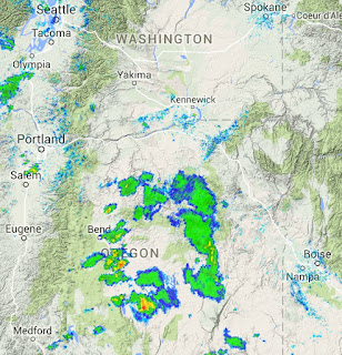
An approaching trough produces upward motion, which helps force thunderstorms, and many were observed over eastern Oregon during the afternoon and early evening (see radar for 5 PM). This trough will also force more marine air inland.
Tomorrow will be a transition day and after that we will be in the upper 60s for at least a week. This cool/wet period will reduce wildfire potential east of the Cascade crest and reduce evaporative loss for agriculture.


No comments:
Post a Comment