

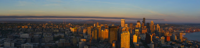
By 8:00 PM the plume was evident on the horizon.

At 8:30 PM it had reached northern Seattle

And by 8:50 PM it had moved past the city.
Now you might ask, why did the plume of smoke not spread in the vertical? What made it stop at one elevation in the low-level northerly flow as a VERY well-defined plume with little vertical depth?
Good question. As shown in the picture above, the smoke plume initially rose upward from the fire. This makes sense because the fire-heated air was warmer than the environmental air at the same level and thus was buoyant. But as many of you know, rising air parcels cools as they ascend to regions of lower pressure aloft, where they expand (called adiabatic cooling). But Saturday evening there was something that blocked the upward motion of the warm air plume from the fire: a strong inversion, in which temperature increases with height.
On Saturday, there was a shallow layer of cooler, northerly flow over the Puget Sound region that was topped by easterly flow aloft, which was quite warm due to its origin over warm eastern Washington and adiabatic compression as it sank down the western slopes of the Cascades. A time-height cross section of winds and temperatures over Seattle on Saturday shows this (the y axis is height in pressure--850 is about 5000 ft, red lines are temperature in C, time increases to the left--in GMT)

As shown in the vertical sounding over Seattle on Saturday, there was a strong inversion between roughly 400 and 600 meters above the surface. Such warmth aloft kills the buoyancy of air rising from below and blocked the upward motion of the smoke plume.

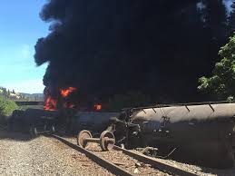
In contrast, to the Everett Fire, the oil train fire in the Columbia Gorge had a smoke plume that rose and mixed through substantial elevation (see pictures)


The reason for the difference? No inversion blocking the plume rise.
Let me end, with an editorial comment. Moving large amounts of oil by train is crazy stuff. Oil trains move through densely populated regions (like Seattle) and next to environmentally sensitive areas (such as right next to Puget Sound and the Columbia River). Trains derail all the time. There are frequent slope failures next to train tracks. Why is our region is taking such a large risk for our population and environment to help move Bakun and other oil to market? And all these oil (and coal) trains make our traffic significantly worse.
Finally, today (Sunday) will be very warm (hitting 90F around Seattle), but changes are already in place that will bring substantial cooling on Monday. And a MAJOR cooling is going to occur mid to late week.
If you were worried that this year is going to be a repeat of last year, don't. The atmospheric circulation is very different this year and high pressure should not hold in place like 2015.


No comments:
Post a Comment