Thursday, December 11, 2014

Storm Nowcast

8:30 PM  I don't know how long I will have connectivity:  my power is flickering, strong gusts are periodically buffeting the house, and I can hear large branches snapping close by.   Some flashes are visible on the horizon:  a sure sign of blowing transformer fuses.

The gusts are amazing....you can hear them several seconds before they hit-- a roaring sound that grows closer and then arrives with my house groaning and the swish of air passing buildings and trees.   Gusts are associated with the turbulent mixing of strong winds aloft down to the surface.

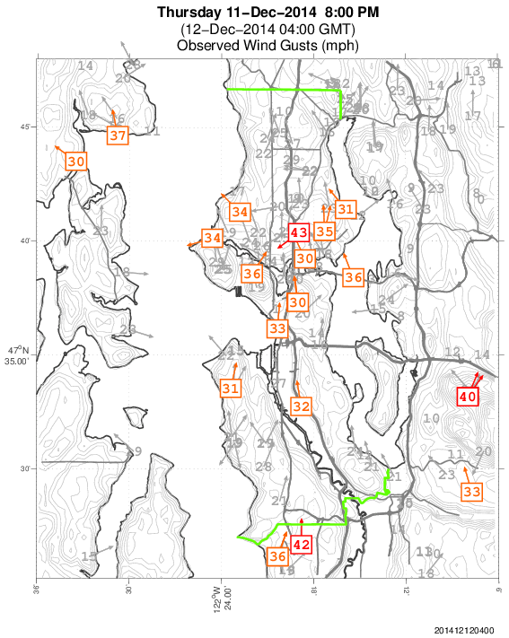
The latest Seattle City Light Windwatch wind map shows plenty of winds between 30 and 45 mph, and stronger winds have hit Sea-Tac, Olympia, and other locations.

6300 CityLight and 63000 Puget Sound Energy customers are out of power at this time...and folks we have not hit the peak of this yet.   The north-south pressure gradient in the Sound is still increasing.

One hour later (9:38 PM, 14,500  City Light customers and 79,000 Puget Sound Energy customers had lost power
...................
The winds are going to hit suddenly and hard during the next few hours if you are in Puget Sound country.

Strong winds reached Olympia and now Tacoma (6:30 PM), with gusts to 48 knots in Olympia last hour.

Strong winds are descending to the surface rapidly.  Here are the winds above Seattle-Tacoma, with the left most reports at 6 PM.  30 knot wind were only a few hundred meters above the surface at this point in time.

Puget Sound Energy outage maps tell the story...lights started going out very rapidly when the winds surged in.

The latest forecast from the NOAA/NWS High Resolution Rapid Refresh System suggests Seattle will feel the winds during the next hour (by 8 PM) and they will be strongest around 10 PM (here is the forecast gust map from HRRR).  50-60 knots over the water, and 30-40 knots over land.
 So get ready for an exciting few hours...it will hit like a wall of wind.  Cook your dinners now!

Feel free to leave comments about the winds if you want to share your observations.

Big Wind Tonight

The models are basically in agreement now on the track and intensity of the cyclone that is moving up our coast and the model evolution compares well with observations, so there is substantial confidence in the forecast I will describe.

The storm...I have seen better defined low centers.  The low center is in the middle of the swirl off of Oregon.

There will be a major blow tonight over western Washington that will certainly cause power outages for some of you.  This event should bring the strongest winds we have seen during the last year, but damage will be mitigated by our leafless trees and the fact that earlier windstorms have done considerable pruning of new growth and weak limbs.

Let me show you the latest sustained wind (not gusts) forecast every 3 hours of surface (10-m) winds and sea level pressure from the UW WRF run starting at 1 PM (2100 UTC).  The Oregon coast gets hit hard...something we have been saying for while.  The storm slowly weakens during the day, but there is plenty of punch left in it as it crosses the NE tip of the Olympic Peninsula

1 PM
4 PM
7 PM
10 PM

At Point Oxford (near Pt. Blanco) on the southern Oregon coast the winds are increasing rapidly, gusting to 60 knots (69 mph)--see below.  Pressure is rising, suggesting that the storm is moving away--which agrees with the models.

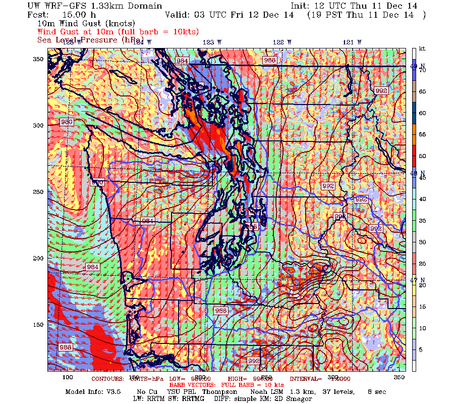
Now, let's turn to the UW Super-Hi resolution forecasts...1.33 km grid spacing--some of the best model resolution of any numerical weather prediction in the country (sponsored by the NW modeling consortium by the way).  Let me show you the gusts (in knots, remember 1 knot=1.15 mph).  Click on images to expand

At 4 PM, very strong winds along the Washington coast (gusting to 60-75 mph).  Long Beach Peninsula is hit hard.  Gust to 30-40 knots over Seattle.

 By 7 PM, coastal winds back off a bit as the low weakens and is about the cross Tatoosh Is.  Strengthening winds over Puget Sound and real bad from Whidbey to Victoria. 
 At 10 PM, a bit stronger over the north Coast and bad news north of the San Juans.  Very strong winds over northern Puget Sound as air surges northward  towards the retreating low.

Bottom Line:  Nearly everyone will experience gusts to 40-50 mph tonight and some more (coast, near the Sound, NW Washington)

I would not plan any ferry trips tonight and if you need to cross the Sound do it before dinner.  I suspect a few hundred thousand folks will lose power in our region, so be ready.

San Francisco Weather Wimpology

The "terrible" and "huge" storm has passed through San Francisco.  Here are the max winds during the past 24 h after the worst has occurred.  Away from the water their gusts hit 13 to 28 mph.  In the forties (mph) near the water and exposed peaks.  We had a lot worse around here yesterday, without a big storm!

 A very strong front went through San Francisco bringing heavy rain for a few hours, with a few tenths to a few inches depending on location.  Northwesteners would yawn at such amounts.

Some San Franciscans have gotten defensive about their weather wimpology:  check out their newspaper coverage.

Wednesday, December 10, 2014

Northwesteners Take Major Storm in Stride while San Francisco Panics

Will Update at noon (Thursday).  Big blow is on for tonight

Heavy rain, winds, flooding:  hardy Pacific Northwest residents take it in stride.

In San Francisco, they panic.


A strong storm is now bearing down on the Northwest, which I will describe in a second.  San Francisco will NOT be hit by this strong low center but will get a bit of a trailing front.  These poor golden-state folks will experience a few inches of rain tomorrow and some gusty winds, reaching perhaps 40-50 mph in the city.  And they are in panic mode, closing down the city's schools, shuttering churches and synagogues.  Canceling meetings and gathering of all types.

In contrast, we have had winds gusting to 70 mph on the coast and 40-60 mph around western Washington today (see graphic).  Our rivers are flooding and heavy rain is striking our region.  We take it in stride.  No problem.  I don't like to call anyone a weather wimp, but....


Today was an extraordinary day, the warmest December day in the history of our region at MANY locations.   You will tell your grandchildren about it one day.  The 24h maximum temps are shown below. Mid to upper 60s in many locations of western Oregon and Washington and 70F in Walla Walla.


And yes, there is thesmall matter of the upcoming storm.

This system is finally starting to develop.  Here are the latest infrared and water vapor images, with my yellow marker indicating the storm.  Not very impressive yet.  One of the signs of a developing storm is a darkening in the water vapor imagery (associated with sinking behind the storm).  I have indicated the darkening with an arrow.


Here is the latest UW WRF runs driven by the GFS model.  In general, the low is slightly weaker than last night and a bit further offshore.   The result will be more modest winds over Puget Sound.  At 1 PM the low is off the central Oregon coast with strong winds (sustained at 50 kts) reaching the coast. Gust could reach 70-80 mph in some exposed locations.


By 10 PM, the low has reached Tatoosh Island, with strong winds along the coast, and winds starting to rev in Puget Sound (perhaps gusts to 30-50 mph).  The low will be weakening rapidly tomorrow night.

Here is a close-up view of the sustained winds over western Washington at this time.  Lots of sustained 30-40 mph over the water.  Half that over the land.  Gusts would be 30-50 mph over Seattle, 40-70 mph on the coast.  A few higher gusts are possible.


A significant event but not the equal of one of our great windstorms (like the Chanukah Eve Storm in 2006).   There will surely be some power outages.

The European Center model is now on the same page as the U.S. GFS.  With both giving essentially the same forecast, our confidence in the prediction is much higher.

 If this thing approached San Francisco, they would probably abandon the city.  But we are made of sterner stuff.


Tuesday, December 9, 2014

Too much weather?


Update tonight (Wed) at 10:30 PM on new blog


BIG NEWS UPDATE at 10:15 AM Wednesday:  At 10 AM, Seattle-Tacoma Airport reported 65F, the WARMEST TEMPERATURE EVER OBSERVED AT SEA-TAC FOR THE MONTH OF DECEMBER.  I repeat this is the warmest temperature every reported for any day in December in the entire climatological record.  Amazing.  Undoubtedly true of other Northwest sites as well.

I had to laugh today when I saw the front page of  the National Weather Service's Seattle forecast office web site.
They had FOURTEEN watches, warnings, and advisories.

I have never seen so many.   Something out of a disaster movie or reminiscent of the plagues that hit Egypt before the Exodus.   High Winds!  Floods! Small Craft Advisory!  High Surf!  Gales! Storms! Rough Bars!  All that was missing were tornadoes, hurricanes, lice, and darkness.  Oh, I forgot, we have darkness living in Seattle during the winter.


But the extremes did not end there!   Many locations got above 60F today...some into the mid-60s (see below).  In western WA and OR in December!  Subtropical air was over us.


We have some major winds coming and ground zero should be the Oregon coast.  If you live there, get ready.  Secure supplies, flashlights, and keep away from potentially falling trees.  But it will be glorious for storm chasing. (I tried to convince some folks along the Washington coast (including the Mayor  of Westport) to start a storm museum and have storm gatherings there during the winter.  It could be a huge tourism magnet.  Filling the hotels, B & Bs and restaurants. They laughed at me.)

A trough will come through Wednesday AM, with wind gusts reaching 60-70 mph (see graphic for 10 AM Wednesday).  The whites and purples along the coast will be the danger zones. There is substantial confidence this is going to happen.

But what you are really interested in is the major coastal cyclone that has been advertised for Thursday.    This is a really interesting event for me.  Rarely do you see the major forecast models in such disagreement this close it to an event.

On one hand, there is the U.S. GFS model, which has been going for a big event for a few days.  The latest run tonight still has a powerful storm, but farther offshore, so a bit less threatening for Washington and particularly Puget Sound.

Here are the latest pressure forecasts from the  UW WRF model.  A 974 hPa low off of northern Oregon at 1 PM (21 UTC) Thursday.   LARGE PRESSURE GRADIENTS along the Oregon coast.

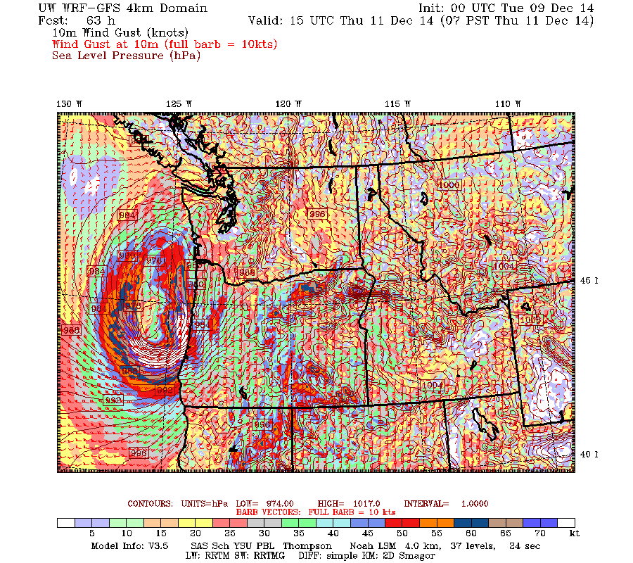
 Here are the associated winds gusts at that time.  BIG WINDS along the Oregon coast, gusting to 60-80 mph.  Seriously, the Oregon coast is going to get hit very hard if this is true.


By 7 PM, this fast-moving low reaches Vancouver Island, but has weakened to 981 hPa.  Very strong winds along the coast (gusting to 60-70 mph), but far less over Puget Sound.   Perhaps gusts to 40-50 mph here.


What about the nemesis of the National Weather Service GFS, the super-duper European Center Model driven by big computers and better data assimilation than used in the U.S.?  It has had much more benign solutions. BUT, it has now come much more into alignment with the U.S. model, although a bit weaker (see forecast for sea level pressure and relative humidity for 4 PM Thursday). Large pressure difference along the Oregon Coast.


Perhaps this is going to be a big win for the American team!  We will see soon enough.

This is a very difficult forecast.  Small storm, which has not even formed yet.  Substantial uncertainty. Amazing we can even attempt to make such forecasts.

But it is getting very clear that the Oregon coast is going to be ground zero for a major onslaught of wind.  Hurricane-force gusts.

And there are so many weather stories that I don't have time to discuss, like the extraordinarily heavy rain that is about to hit northern California.  A drought buster.

Monday, December 8, 2014

Is a Major Windstorm Headed for the Northwest?

For the last few forecast cycles, the U.S. global model, the GFS, has been predicting that a very strong Pacific storm will develop off of northern California and then slam into the Pacific Northwest on Thursday.

But there were reasons to be wary about this forecast.  The European Center model, which is usually superior to the U.S. GFS, had no such strong cyclone.  Other modeling centers have found different solutions from the GFS (weaker storm) Furthermore, the U.S. model had the position and intensity of the system varying substantially.

But tonight's forecast is highly consistent with those made earlier today, and the forecast solution of other major centers, such as the UKMET office are now doing something similar.

Finally, we are now only 48h out and it is unusual to have major forecast failures at that time range. But it is also unusual for there to be such major discrepancies between major models this close in.

Let's start by looking at the latest sequence of 12-km UW WRF runs, driven by the National Weather Service GFS model. These are surface charts with the lines being pressure lines (isobars).

10 PM Wed. you see a 982 hPa (mb) low off of northern CA

 By 4 AM Thursday it had deepened (975 hPa).  That is a very deep low center for our neighborhood.
Intense pressure difference (gradient) to the south and east of the low.  Big winds.

 By 10 AM Thursday the low had weakened a bit (976 hPa) and hurricane-force winds are hitting the northern Oregon coast.   This is very serious stuff.

 And then the system weakens substantially as it crosses Vancouver Island Thursday afternoon (4 PM is shown). Strong winds over Puget Sound (30-50 mph gusts perhaps)

Just a small shift in the storm or how it revs up could greatly change the details of this forecast, so PLEASE keep this uncertainty in mind.

Take a look at the model wind gust forecast for 8 AM on Thursday.  How many ways can you say amazing?  75 knot gusts and more.  We are talking about power outages and damage on the Oregon coast.


The UK MET office model, which is the second best in the world, is now going for a storm, but a weaker one.  Here is the forecast for 4 PM Thursday.  A 983 hPa low on the WA coast.   A bit different solution and not as strong.


The Canadian Meteorological Center (CMC) GEM model, the fourth best in the world is NOT producing a storm:

At the same time, the European Center model, normally the most skillful, has weaker low center  (988 hPa) over SW Washington (shading is relative humidity, solid lines are pressure)


This is a small storm, with substantial uncertainty remaining, but we need to watch it carefully.  But tomorrow night we should have much more confidence about what will happen.

And we should not forget the HUGE amount of rainfall that will fall in the next 72 hr ( see forecast). 5-10 inches in the Olympics, on Vancouver Island, and the southern Coast Mountains.  Huge amounts in norther CA.


As a result, the NWS River Forecast Center is going for flooding on several western WA rivers, some reaching moderate flood levels.  And there is the potential for some landslides.


Sunday, December 7, 2014

When is normal not normal? And the coming heavy rains.

The official November temperatures are now available for Seattle-Tacoma Airport from the National Weather Service.  Here are the numbers:


The average maximum, minimum, and daily monthly-mean temperatures are all within 1F of normal (the average values for the month for 1981-2010).

So does that mean we experienced normal temperatures most of the month?  The answer is NO!

To illustrate this, here is a plot of the temperatures each hour for November, plus the average daily highs (red) and lows (blue).
The temperatures on any particular day have been ANYTHING but average. The first ten days or so were MUCH warmer than normal, with most days having maxima and minima far greater than average.  Then we had a 8-9 days of far colder than normal temperatures, followed by another period of much warmer than normal temperatures, followed by a much colder than normal end to the month.

Very few days were anything like normal with a high on the red line and a minimum on the blue line.  Yet, when you average these substantial swings you get normal conditions.

Folks..this is not unusual.  Very few days are normal and averaging conditions for a month, a year or whatever can be very deceptive.

This is going to be a very wet week for the Northwest and northern California, with a deep trough over the eastern Pacific that will bring very moist, warm air and the jet stream right into us.

To illustrate, here is the flow pattern near jet stream level (300 hPa, 30,000 ft) for Wednesday morning.  Colors are wind speed (yellows and oranges are strongest), wind barbs, and heights (like pressure).   A trough over the Gulf of Alaska and a strong jet heading towards the West Coast.  This is a very "juicy" pattern for us.


Let me show you the for the precipitation forecast for the next 72-h (ending 4 PM Wednesday) and be prepared to be impressed.  10-20 inches over the Olympics and mountains of Vancouver Island.   Up to 5 inches in the north Cascades

What about snow?  Not much except for the BC Cascades.  The reason?  This is going to be warm air.  Very bad for ski prospects in the Cascades.


During the next 72 h, the heaviest precipitation moves down into California, and boy do they need it.  Large amounts (5-10 inches) over northern CA and the Sierra that will help immensely.  If you like eating CA vegetables, you should be glad.


What about snow during that period?  With the jet going south, temps will cool a bit over the Northwest, allowing snow at higher elevations (up to a foot perhaps about 4000 ft).  But the real snow story is in California where the high Sierra will get several feet.   Really good.


There is much I don't have time to go into now.  Strong winds, particularly along the coast.   Potential windstorm over Oregon later in the week.   And, of course, the potential/near certainty for flooding.

Rake your leaves today, clear your gutters, and make sure the street drains are open!

Friday, December 5, 2014

International Beauty Movement Membership Available Now Online


Fashion and Entertainment Membership Available Worldwide With The International Beauty Movement


The International Beauty Movement Membership Program is now accepting member applications.


The International Beauty Movement is designed to further the career goals and give international exposure to hair stylists, makeup artists, aspiring models, publicists, photographers, fashion and entertainment bloggers, social media bloggers, broadcasting students, fashion journalists, entertainment journalist, fashion and entertainment social networkers, event directors, casting agents, casting directors, videographers, fashion columnist, beauty columnist, film producers, online promotion team volunteers, online social media promoters, event promoters, clothing designers, fashion stylists, promotion assistants, social media assistants, fashion graphic artists, and fashion entrepreneurs.


If you are looking for the perfect opportunity to take your career to the next level, showcase your talent or work on a global scale, expand your career, gain worldwide exposure for your talent, expand your professional portfolio in the fashion and entertainment industry, and increase your opportunity of  having your talent or work recognized or being seen by fashion industry and entertainment industry insiders worldwide, then you will want to apply for a membership with the International Beauty Movement for an opportunity that could create high paying jobs for you in the fashion or entertainment industry.


The International Beauty Movement will be releasing a new industry online magazine in 2015 entitled “Project Couture” and this magazine will be dedicated to featuring and promoting only the members of the International Beauty Movement and their extraordinary talent or work, so in order to have your talent or work possibly showcased in “Project Couture Magazine” you must apply for a membership at this website link: http://internationalbeaut.wix.com/internationalbeauty


The International Beauty Movement aka I.B.M. is a fashion and entertainment member network that is designed to open doors for the most creative and unique people in the fields of fashion, beauty, and entertainment, that are seeking an excellent way to promote their talents while working with a great international team of fashion and entertainment professionals, and receive recognition for your unique skills or talent.


The I.B.M. Membership Program is dedicated to worldwide promoting of aspiring models, professional models, hair stylists, makeup artists, salons, fashion and beauty columnist, fashion and beauty bloggers, fashion photographers, entertainers, aspiring and professional actresses, and pageant winners worldwide that have that special beauty or creative talent that should be recognized by industry insiders.


Konscious Money Entertainment Group Creator of the International Beauty Movement has created a strong presence in both the entertainment and fashion industry with it’s internationally known Ripping Runways Magazine publication and Girl 9 Magazine For Men, and as a result, Konscious Money Entertainment and Ripping Runways Magazine is responsible for featuring some of the hottest and most beautiful female models and beauty pageant winners worldwide since 2012, and some of the most talented singing and acting talent in the entertainment industry.


The International Beauty Movement aka I.B.M. is a fashion and entertainment member network that is designed to open doors for the most creative and unique women in the fields of fashion, beauty, and entertainment, that need assistance in being promoted or recognized for their unique beauty or talent, and The I.B.M. is dedicated to worldwide promoting of aspiring models, professional models, hair stylists, makeup artists, salons, fashion and beauty columnist, fashion and beauty bloggers, fashion photographers, entertainers, aspiring and professional actresses, and pageant winners worldwide that have that special beauty or creative talent that should be recognized by industry insiders.


The International Beauty Movement is now accepting membership applications, so if you are looking for an excellent opportunity to network with like minded people and possibly have your talent or work featured in our online magazine and other sites that we promote talent, also by joining the I.B.M. it will allow you to use your creative skills and talent, as well as offer you greater opportunities in the fashion and entertainment industry, you should join the International Beauty Movement Organization and request information on our International Internship Program if you are interested in lending your skills to help other members in this global beauty movement, or you would like to increase your skills.


To apply for a membership with the International Beauty Movement, you must currently be a hair stylists, makeup artists, aspiring model, publicist, photographer, fashion and entertainment blogger, social media blogger, broadcasting student, film student, fashion journalist, entertainment journalist, fashion and entertainment social networker, event director, casting agent, casting director, videographer, fashion columnist, beauty columnist, film producer, online promotion team volunteer, online social media promoter, event promoter, clothing designer, fashion stylist, promotion assistant, social media assistant, fashion graphic artist, and fashion entrepreneurs.


If you fit any of the above positions, please fill out our membership form and state that you are looking for internship opportunities if you are interested in an internship with the International Beauty Movement.


So if you really serious and think you are ready to take your career to the next level and you are confident and have a competitive spirit, please submit yourself to our Internship program and we will contact you if you meet the qualifications that we are looking for. A website link or portfolio link of your work will also be apart of the application process.


Please Feel Free to Contact us using the contact form

if you need more information


You must visit our website below

to fill out a membership form:


International Beauty Movement:


These are links to our other websites you may want to also visit:


Salon Savvy Magazine:


Ripping Runways Magazine:


Girl 9 Magazine:


Konscious Money Entertainment Group:


You can read our magazines at links below:


Ripping Runways Online Magazine:


Girl 9 Online Magazine:


Salon Savvy Magazine:


Please visit our casting call link to view all of our current casting calls for female models and stylists at: http://rippingrunways.blogspot.com/